Weather
Dangerous SoCal Heat Wave Nears Its Peak: Here's When Relief Is Coming
The most dangerous stretch of Southern California's prolonged heat wave hasn't hit yet, according to forecasters.


The most dangerous stretch of Southern California’s prolonged heat wave is expected to end by Saturday, but residents will likely have to wait until next week for the biggest relief.
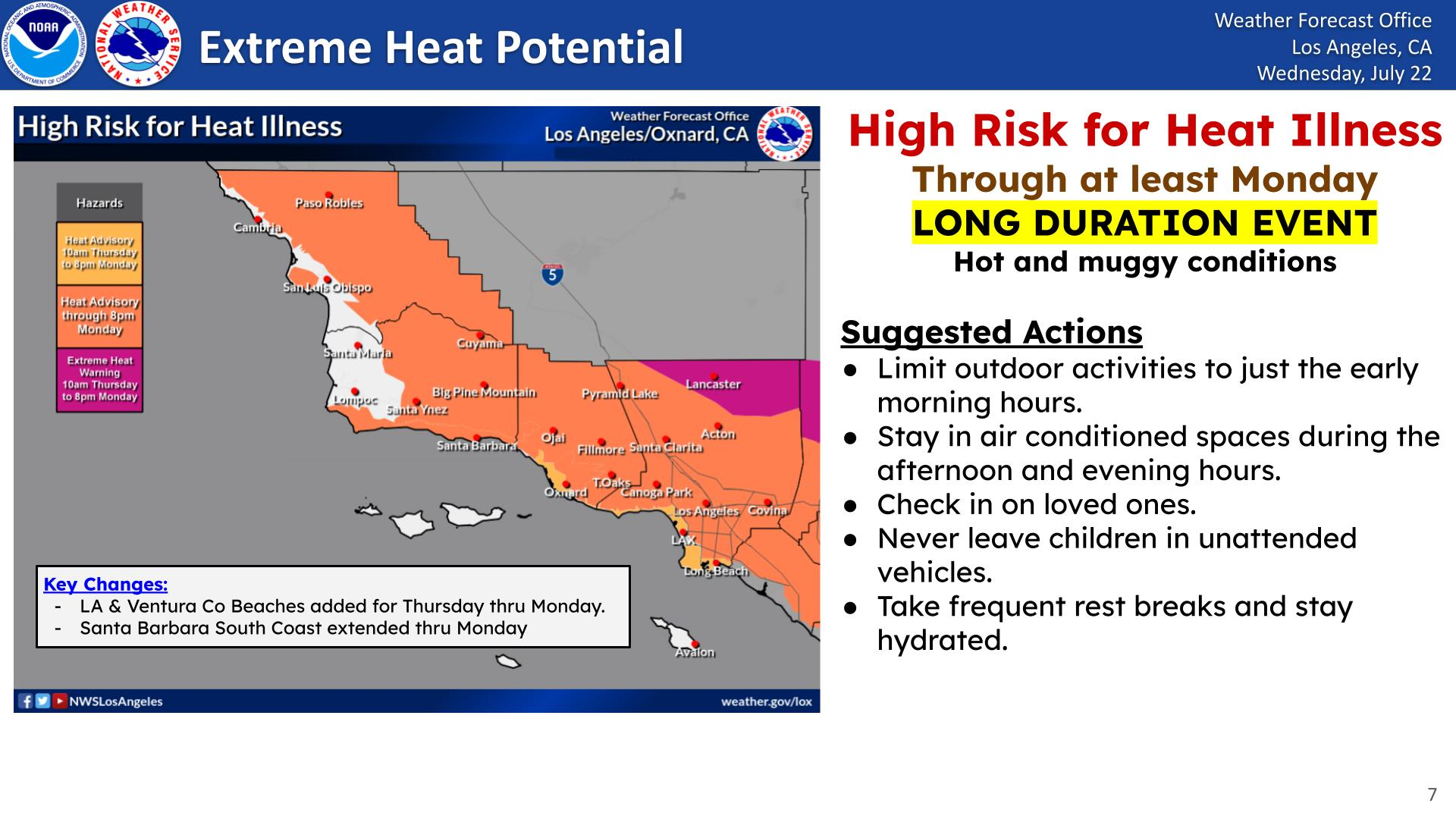
Heat advisories and extreme heat warnings are scheduled to remain in effect until 8 p.m. Monday across much of Los Angeles, Orange, Riverside, San Bernardino and San Diego counties.
A gradual cooldown should begin Sunday as the high-pressure system responsible for the heat starts moving east and cooler ocean air pushes farther inland. Temperatures will fall a few more degrees Monday before the heat threat largely subsides Tuesday, according to the National Weather Service.
Find out what's happening in Los Angelesfor free with the latest updates from Patch.
The change will not immediately bring seasonable weather everywhere. Inland communities could remain about 5 degrees hotter than average through Wednesday, and the deserts will continue to see triple-digit temperatures, according to the NWS.
Forecasters are also monitoring the possibility that high pressure will rebuild late next week, potentially bringing yet another round of intense heat.
Find out what's happening in Los Angelesfor free with the latest updates from Patch.
Where The Heat Will Be Worst
Friday and Saturday are expected to bring the region’s highest overall heat risk, particularly across the Inland Empire, Coachella Valley and other desert and mountain communities.
In Los Angeles County, highs in the western San Fernando Valley are forecast to reach 100 to 107 degrees through Saturday. The San Gabriel Valley could see temperatures from the mid-90s to about 102 degrees.
Downtown Los Angeles and nearby areas in the basin will generally reach the mid-80s to mid-90s. Beach communities will be cooler, with temperatures mostly in the upper 70s and 80s, though locations farther from the water could approach 90 degrees, according to the NWS.
A heat advisory covers much of Los Angeles County, while an extreme heat warning is in effect for the Antelope Valley floor.
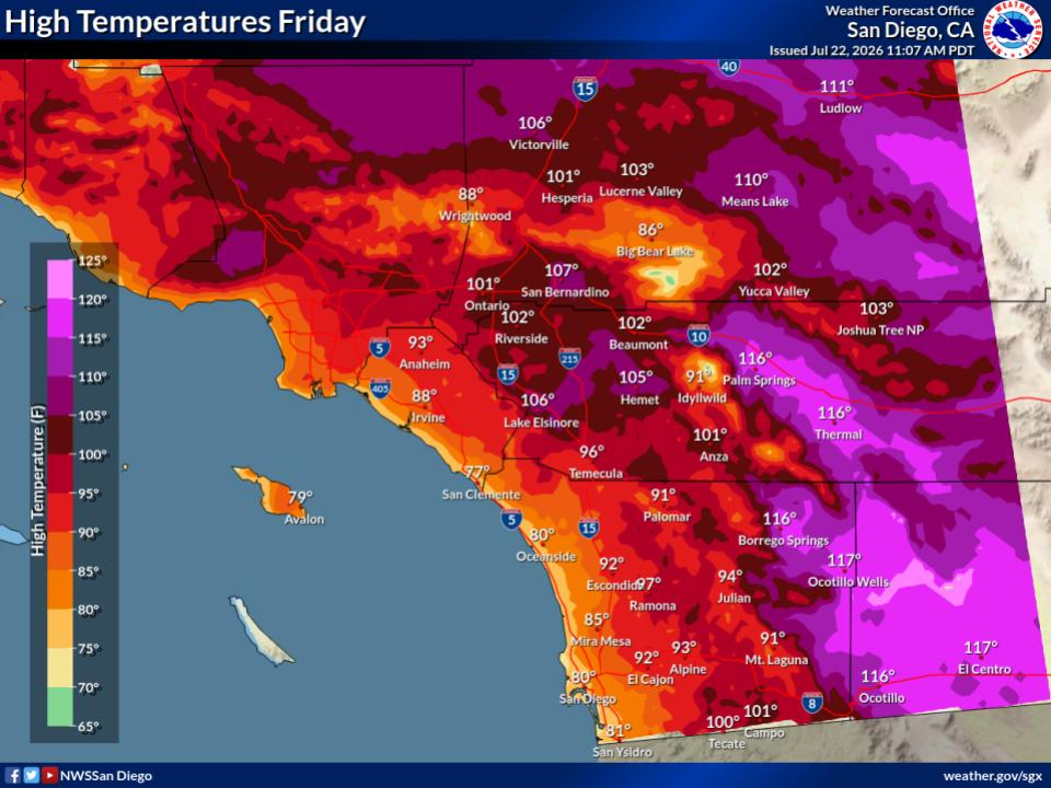
In Orange and San Diego counties, temperatures near the coast will hover around 80 degrees, but inland areas are expected to run roughly 8 to 12 degrees above average.
Heat advisories cover Orange County’s coastal and inland areas, along with San Diego County’s coastal communities and valleys. Extreme heat warnings are in effect for the San Diego County mountains and deserts.
The Inland Empire will face some of the region’s most punishing temperatures, with highs ranging from the upper 90s to around 110 degrees. The Weather Service expects major to extreme heat risk there Friday and Saturday.
Southwest Riverside County will be somewhat cooler but still unusually hot. The Temecula Valley is expected to approach the upper 90s over the next several days.
An extreme heat warning also covers the San Gorgonio Pass near Banning and the Coachella Valley. Lower desert temperatures could reach 114 to 118 degrees, including highs at or above 115 degrees around Palm Springs, Indio and Rancho Mirage.
Warm Nights Add To The Danger
The daytime temperatures will be compounded by higher humidity and unusually warm nights, leaving little opportunity for people’s bodies or homes to cool down, forecasters said.
Overnight lows along the coast and in many valleys will remain in the upper 60s to mid-70s. In the lower deserts, temperatures may not fall below the 90s for several nights.
Forecasters said the prolonged daytime heat, warm overnight conditions and increased humidity will raise the risk of heat illness, particularly for people without reliable air conditioning.
A snapshot of temps for a few locations: hot temperatures over the weekend especially, & notably not a lot of overnight relief with many areas remaining above ~70 deg all night. Hydrate frequently, avoid strenuous outdoor activity, & keep an eye on your neighbors this week! pic.twitter.com/h5owAQrjFe
— NWS San Diego (@NWSSanDiego) July 22, 2026
Residents are urged to drink plenty of fluids, spend time in air-conditioned spaces and avoid extended exposure to direct sunlight.
When Will The Heat Wave End?
The first signs of relief should arrive Sunday, when increasing onshore flow could bring cooler coastal air and a return of some morning clouds.
Sunday will still be hot enough for heat advisories and warnings to remain in place, however. Additional cooling is expected Monday, but most alerts are scheduled to continue through that evening.
By Tuesday, forecasters expect temperatures to have fallen enough to end the immediate heat threat across the Los Angeles area.
Cooling will also continue across Orange, Riverside, San Bernardino and San Diego counties into the middle of the week. By Wednesday, coastal highs should range from the mid-70s to around 80 degrees. The Inland Empire will remain in the 90s to around 102 degrees, while lower deserts could still reach 108 to 112 degrees, according to the NWS.
A limited surge of monsoonal moisture could also bring more clouds and a slight chance of afternoon thunderstorms over the mountains Sunday. Forecasters cautioned that computer models disagree on how much moisture will reach Southern California.
Heat Fuels Poor Air Quality
The South Coast Air Quality Management District issued an ozone advisory for much of the region through 8 p.m. Monday as the prolonged heat fuels a multiday smog event.
Air quality could reach levels considered unhealthy for sensitive groups or worse in the San Fernando and San Gabriel valleys, along with Southwest Riverside County. Unhealthy conditions or worse are possible in the Santa Clarita Valley, Glendora and the Inland Empire.
Children, older adults and people with asthma or other respiratory conditions should limit prolonged outdoor exertion when air quality reaches unhealthy levels, officials said.
City News Service contributed to this report.
Get more local news delivered straight to your inbox. Sign up for free Patch newsletters and alerts.