Weather
OC's Heat Wave Is Getting Even Worse: Hottest Week Of Year Forecast
The heat wave is expected to peak in the middle of the week, but temperatures will remain hot next weekend as well, forecasters said.

ORANGE COUNTY, CA — The hottest week of the summer has arrived, igniting a heatwave that will bring soaring temperatures to Orange County, prompting health warnings and triggering fire danger in multiple regions.
It's a prolonged heat wave with no end in sight.
"We've got a pretty strong — especially for this time of the year — area of high pressure that is over parts of Southern California. Right now it centers more over New Mexico and Texas, but it's pretty broad, so we're kind of getting looped into that warmer air, and as we move into the middle and the end of the week, that high pressure system is going to begin to shift west so that we're more under its influence. That's why we're going to see our warmer conditions Wednesday, Thursday and Friday," said Casey Oswant, a meteorologist for National Weather Service in San Diego.
Find out what's happening in Orange Countyfor free with the latest updates from Patch.
According to the National Weather Service, all areas 5 to 10 miles inland of the beaches will likely see high temperatures in range of 100 to 110 by Tuesday or Wednesday, with little change through Friday or Saturday. The daytime highs and overnight lows will be 8 to 12 degrees above normal, which will greatly exacerbate the heat risk as there will be no time for a person's body to release the heat stress.
The heat wave is expected to peak Tuesday through Thursday, but temperatures will remain hot next weekend as well.
Find out what's happening in Orange Countyfor free with the latest updates from Patch.
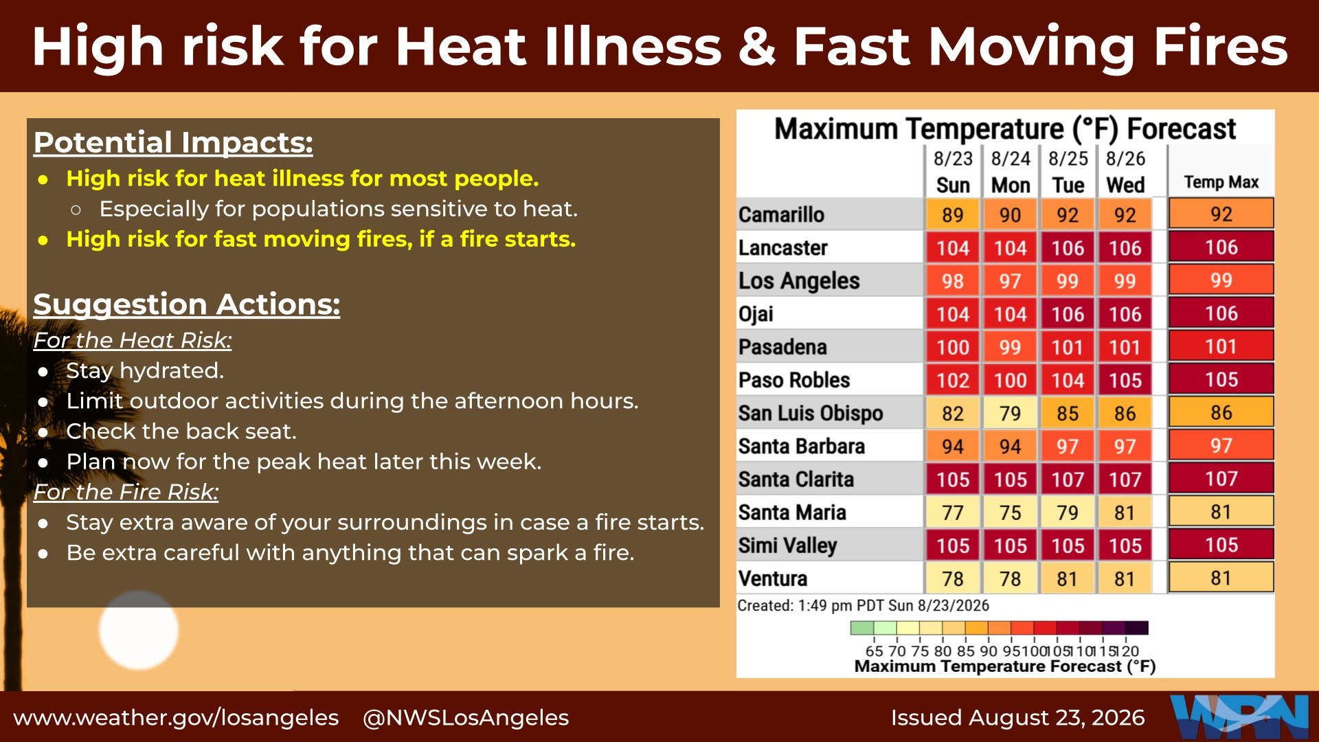
Orange County is also feeling the simmering temps with a heat advisory in effect until at least 10 a.m. Tuesday followed by an extreme heat watch until Friday. Anaheim reached a high of 97 on Sunday and was expected to hit 94, 96, 96 and 98 Monday through Thursday.
While highs in coastal areas will mainly remain below 90 degrees, overnight temperatures will not drop below the lower 70s, which will especially affect those without access to air conditioning.
According to the National Weather Service, there is some cooling expected on Saturday, but in the past these heat waves have held on a little longer than forecast.
"We'll see some cooling on Saturday but some people probably won't notice because it will still be in the upper 90s to low hundreds left of the mountains, and still above 110 in the low deserts. But there is some indication the end of the weekend, early next week that ridge of high pressure is going to get pushed back to the east, so we may see some more noticeable cooling, that's really at the very end of the forecast period so there's still some uncertainty," said Oswant.
"The ridge remains stationary and locked in over the desert southwest, translating to the persistence of high temperatures remaining on an average of 5 to 10 degrees above average throughout the rest of the workweek," the National Weather Service said.
The weather will also produce elevated wildfire danger, with "increased risk for large plume-dominated fire behavior" away from the coast, according to the National Weather Service. No major wind events are expected in the Southland this week.
Health officials advised people to drink plenty of fluids, stay in an air-conditioned room, stay out of the sun during the hottest parts of the day and check up on relatives and neighbors.
The public was also urged to never leave children or pets in parked vehicles for even a minute, as temperatures inside vehicles can reach deadly levels in virtually no time.
City News Service contributed to this report.
Get more local news delivered straight to your inbox. Sign up for free Patch newsletters and alerts.