Weather
Muggy Conditions To Stifle Bay Area As Tropical Moisture Persists
The remnants of a tropical storm are boosting humidity across the region, while forecasters say typical summer conditions will soon return.


SAN FRANCISCO, CA — Bay Area residents can expect another muggy night before more typical summer weather returns, as moisture from the remnants of Tropical Storm Elida continues to influence the region's humidity, according to the National Weather Service.
While the Bay Area isn't experiencing direct impacts from the former tropical cyclone, lingering moisture has pushed dew point temperatures into the mid-50s to lower 60s, making conditions feel noticeably more humid than usual, said Roger Gass, a meteorologist with the National Weather Service's Bay Area forecast office.
"We have experienced some mid-level high clouds across the region that are clearing out right now, but it is still muggy," Gass said. "The moisture from that system is definitely having an impact on our humidity levels."
Find out what's happening in San Franciscofor free with the latest updates from Patch.
The increased humidity comes as inland portions of the Bay Area and Central Coast remain under a heat advisory through 9 p.m. on Tuesday. Inland communities, including Santa Rosa and Napa, are expected to experience the hottest conditions, while coastal areas, including San Francisco, are expected to stay cooler thanks to persistent onshore winds.
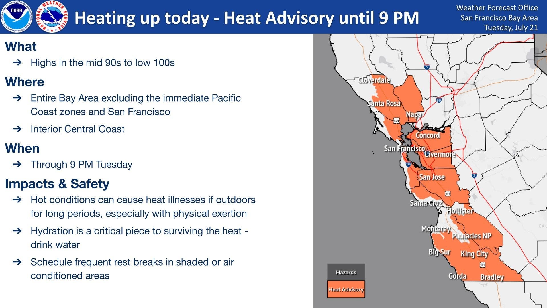
Gass said the muggy conditions will likely be most noticeable Tuesday night before the tropical moisture exits the region.
Find out what's happening in San Franciscofor free with the latest updates from Patch.
"It's definitely going to feel muggy tonight," he said. "But we're expecting that to be generally getting out of the area by tomorrow."
As the tropical moisture moves away and is absorbed into the broader weather pattern, the Bay Area's familiar marine layer is expected to return, allowing low clouds and cooler air to spread inland overnight and into Wednesday.
Although lightning strikes have been detected offshore along the Northern California coast, Gass said forecasters are not expecting thunderstorms or lightning over the Bay Area.
The added humidity also isn't expected to significantly change wildfire conditions.
"It's still warm and dry in the higher elevations across the region, so we're not expecting any lightning," Gass said, noting that lightning is the leading natural cause of wildfires. "We don't have any strong offshore winds or anything like that."
Residents should continue taking precautions during the heat advisory by staying hydrated, limiting strenuous outdoor activity during the hottest part of the day and seeking air-conditioned spaces or shade when possible, Gass said.
While tropical moisture occasionally reaches the Bay Area from storms in the Eastern Pacific, Gass said the muggy conditions should be short-lived, with more typical summer weather expected to return by Wednesday afternoon.
Get more local news delivered straight to your inbox. Sign up for free Patch newsletters and alerts.