Weather
Thunderstorms, Heat Wave Returns Too: CT's Latest Forecast Details
Find out the expected timing for dangerous heat and potential storms, according to meteorologists.


High heat and humidity are back in the forecast for Connecticut starting on Tuesday, and it will seem like it is in the triple digits.
The National Weather Service has issued heat advisories for the state for Tuesday and Wednesday, when temperatures are expected to soar into the 90s. Combined with the expected humidity, it will feel even hotter, forecasters said.
Heat advisory issued
Find out what's happening in Across Connecticutfor free with the latest updates from Patch.
For northern Connecticut, the heat advisory runs from 11 a.m. Tuesday to 8 p.m. Wednesday, with heat index values of up to 103 degrees expected.
For southern Connecticut, the heat advisory runs from noon Tuesday through 9 p.m. on Wednesday, with heat index values of up to 101 expected.
Find out what's happening in Across Connecticutfor free with the latest updates from Patch.
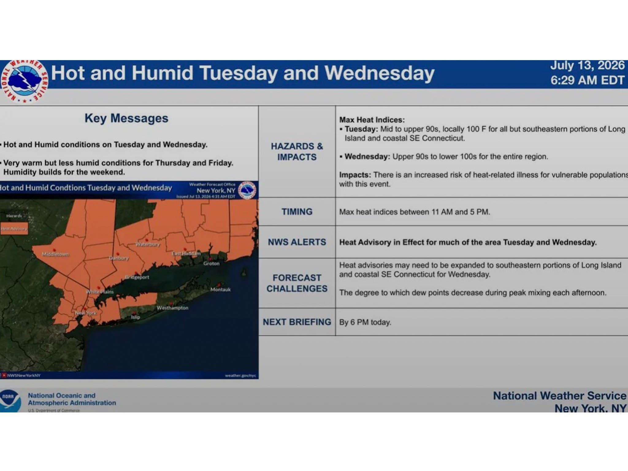
The heat index values are expected to be at their highest on Wednesday, according to the advisory.
Residents are urged to drink plenty of fluids, stay in air conditioning and check on vulnerable friends, family members and neighbors. Those who have to work outdoors should take frequent breaks in shade or air conditioning.
WFSB says today will be “the last comfortably warm day before heat and humidity begin to build.” The station is calling both Tuesday and Wednesday “First Alert Weather Days,” due to the expected heat and humidity levels.
“If you notice a hazy sky on Tuesday afternoon, it’s due to smoke from Canadian wildfires,” WFSB reports. “At this point, significant air quality impacts are not expected, but we’ll continue to monitor conditions as heat and ground-level ozone could create localized air quality concerns.”
Next thunderstorm chance
According to WFSB, a weak cold front will move through Connecticut late Wednesday, with an isolated thunderstorm possible.
“Behind the front, humidity drops off significantly, and temperatures begin to ease as well,” WFSB reports. “Highs will be around 90 on Thursday (if we reach 90 then our 3rd heat wave of ‘26 will be achieved) before falling back into the mid 80s by Friday.”
Read More:
- Teen, 15, Dies After Falling Into The Water
- Teen On Motor Scooter Killed In Crash: Report
- Man Killed In Scooter Crash: Police
Here are the forecast details for northern Connecticut via the National Weather Service:
Today: Mostly sunny, with a high near 87. Southwest wind 7 to 10 mph, with gusts as high as 20 mph.
Tonight: Mostly clear, with a low around 66. South wind 7 to 10 mph.
Tuesday: Sunny and hot, with a high near 96. Heat index values as high as 104. Southwest wind 5 to 13 mph, with gusts as high as 23 mph.
Tuesday Night: Mostly clear, with a low around 75. Southwest wind 7 to 10 mph, with gusts as high as 20 mph.
Wednesday: Mostly sunny and hot, with a high near 95. Northwest wind 8 to 13 mph, with gusts as high as 23 mph.
Wednesday Night: Partly cloudy, with a low around 66. Northwest wind 5 to 9 mph becoming calm after midnight.
Thursday: Mostly sunny and hot, with a high near 91. Light west wind increasing to 9 to 14 mph in the morning. Winds could gust as high as 24 mph.
Thursday Night: Mostly clear, with a low around 64. Northwest wind 5 to 9 mph.
Friday: Sunny, with a high near 87. Light northwest wind increasing to 6 to 11 mph in the morning.
Friday Night: Partly cloudy, with a low around 62. Northwest wind around 5 mph becoming calm in the evening.
Saturday: A chance of showers and thunderstorms. Partly sunny, with a high near 86. Calm wind becoming west 5 to 8 mph in the afternoon. Chance of precipitation is 30%.
Saturday Night: A chance of showers and thunderstorms. Mostly cloudy, with a low around 64. South wind around 7 mph. Chance of precipitation is 50%.
Sunday: A chance of showers. Partly sunny, with a high near 87. Southwest wind 6 to 9 mph. Chance of precipitation is 30%.
Here are the forecast details for southern Connecticut via the National Weather Service:
Today: Sunny, with a high near 86. South wind around 9 mph.
Tonight: Mostly clear, with a low around 68. Southwest wind around 8 mph.
Tuesday: Sunny, with a high near 91. Heat index values as high as 95. Southwest wind 8 to 13 mph.
Tuesday Night: Mostly clear, with a low around 76. West wind 10 to 13 mph.
Wednesday: Sunny, with a high near 96. West wind 8 to 10 mph.
Wednesday Night: Partly cloudy, with a low around 70.
Thursday: Mostly sunny, with a high near 91.
Thursday Night: Partly cloudy, with a low around 69.
Friday: Sunny, with a high near 86.
Friday Night: Partly cloudy, with a low around 67.
Saturday: A 30 percent chance of showers and thunderstorms. Mostly sunny, with a high near 84.
Saturday Night: A 40 percent chance of showers and thunderstorms. Mostly cloudy, with a low around 68.
Sunday: A 30 percent chance of showers. Partly sunny, with a high near 86.
Get more local news delivered straight to your inbox. Sign up for free Patch newsletters and alerts.