Weather
Nor'easter Storm Track Changes For CT: Here's What That Means For Us
Find out when to expect stormy weather in Connecticut, according to forecasters.


Meteorologists are expecting a nor’easter will bring heavy rain and strong winds to Connecticut this weekend, with recent models showing the storm tracking closer to the state.
While eastern Massachusetts is predicted to be hardest hit by the storm, Connecticut residents can anticipate a wet and windy weekend, according to meteorologists.
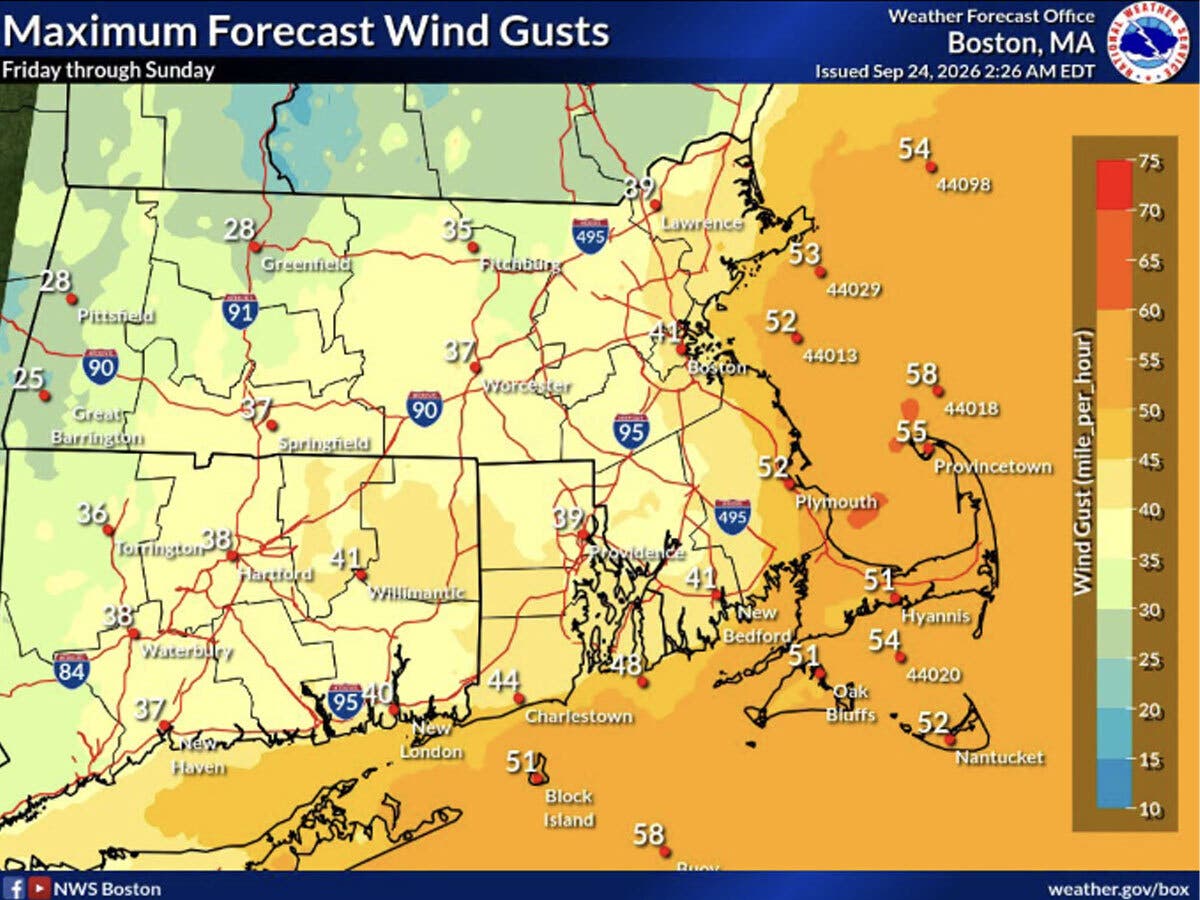
The National Weather Service reports the storm will bring strong winds between Friday and Sunday, with the potential for downed limbs, power outages and coastal flooding.
Find out what's happening in Across Connecticutfor free with the latest updates from Patch.
The most likely timeframe for the worst of the storm is late Friday and Saturday, with gusty winds lingering into Sunday, though they won’t be as strong on Sunday, according to the National Weather Service.
Timing and specifics of nor'easter storm
Find out what's happening in Across Connecticutfor free with the latest updates from Patch.
WTNH predicts rain will arrive on Friday afternoon and evening.
“For Connecticut, a prolonged period of impacts starting on Friday and continuing through early Monday with strong winds, some power outages, heavy rain at times, and coastal high tide flooding,” WTNH reports.
WTNH anticipates Saturday will bring heavy rain on and off, with gusty winds, followed by more periods of heavy rain and gusty winds on Sunday. Power outages are possible both days, according to WTNH. It predicts southeastern Connecticut and the coast will get the strongest winds, at 45 to 50-plus miles per hour. Most of central Connecticut will get 35 to 45 mile per hour winds, while the northwest corner will get 25 to 35 mile per hour winds, WTNH predicts.
WFSB is forecasting wind gusts will be in the 30-40 mile per hour range, with isolated power outages.
“It will be raw with temps running nearly 10° below normal,” WFSB reports. “When it comes to rain, 1-2” could add up across the state (perhaps locally higher amounts).”
Daytime highs through Monday are predicted to be in the mid-60s, according to the National Weather Service.
Read More:
- Man Found Dead In Pool: Police
- Man Killed In Highway Crash, ID Released: Police
- Former Local Basketball Player Killed In Out-Of-State Shooting: Police
Eversource issues storm update
Eversource said it continues to closely monitor the weather and is ready for the heavy rain, strong winds and possible flooding expected to impact the state – especially the shoreline. The energy company said it is bringing in outside crews who will work alongside the full contingent of Eversource lineworkers and will be prepositioned around the state so they’re ready to quickly and safely respond to any damage or outages caused by this storm.
“We’ve been monitoring this storm for the last several days, holding storm-team planning conference calls and preparing accordingly,” said Eversource President of Connecticut Electric Operations Don Scacco. “The high winds expected with this storm have the potential to bring down trees and branches onto electric lines and equipment, causing damage and power outages. We will have hundreds of line and tree crews in position around the state and ready to respond as quickly and safely as possible to whatever this storm may bring, and we’ll stay on the job until every affected customer has their power back.”
Along with high winds and heavy rain, this storm could also bring some flooding to parts of the state and Eversource reminds customers to stay out of flooded basements. Any wet electric wiring is extremely hazardous, and loose wires should be considered “live.” If that happens, all electrical wiring will need to be inspected.
Eversource natural gas customers should be aware that gas systems can also be affected by flooding, and if equipment is submerged it will need to be shut off, safety checked and relit by a company technician. Customers should also immediately leave their home or business if they smell gas and call 911.
Customers are also encouraged to prepare by assembling or restocking a storm kit that includes essentials like flashlights, batteries, water, non-perishable foods, any needed medications, pet food and other necessities. In addition, before the storm, make sure cell phones and devices are fully charged, review or create an emergency plan with family members and prepare to check on elderly neighbors and friends.
Here are the forecast details for southern Connecticut via the National Weather Service:
Today: Sunny, with a high near 66. Northeast wind 15 to 17 mph.
Tonight: Mostly cloudy, with a low around 51. Northeast wind around 15 mph.
Friday: A 30 percent chance of showers after 2 p.m. Partly sunny, with a high near 66. Breezy, with a north wind 18 to 21 mph.
Friday Night: Showers likely, mainly after 2 a.m. Mostly cloudy, with a low around 54. Breezy, with a north wind 18 to 20 mph, with gusts as high as 32 mph. Chance of precipitation is 60%. New precipitation amounts between a tenth and quarter of an inch possible.
Saturday: Showers. High near 64. Breezy, with a north wind around 23 mph, with gusts as high as 36 mph. Chance of precipitation is 80%. New precipitation amounts between a half and three quarters of an inch possible.
Saturday Night: Showers. Low around 53. Chance of precipitation is 80%. New precipitation amounts between a half and three quarters of an inch possible.
Sunday: Showers. High near 64. Breezy. Chance of precipitation is 80%.
Sunday Night: A 50 percent chance of showers. Cloudy, with a low around 56.
Monday: Mostly cloudy, with a high near 65.
Here are the forecast details for northern Connecticut via the National Weather Service:
Today: Sunny, with a high near 66. Northeast wind 10 to 13 mph, with gusts as high as 24 mph.
Tonight: Mostly cloudy, with a low around 49. North wind 7 to 9 mph.
Friday: Partly sunny, with a high near 66. Breezy, with a north wind 13 to 20 mph, with gusts as high as 30 mph.
Friday Night: Showers likely, mainly after 3 a.m. Mostly cloudy, with a low around 53. Breezy, with a north wind 16 to 21 mph, with gusts as high as 32 mph. Chance of precipitation is 60%. New precipitation amounts between a tenth and quarter of an inch possible.
Saturday: Showers likely. Cloudy, with a high near 62. North wind around 17 mph, with gusts as high as 31 mph. Chance of precipitation is 70%.
Saturday Night: Showers, with thunderstorms also possible after 2 a.m. Low around 52. North wind around 17 mph, with gusts as high as 34 mph. Chance of precipitation is 80%.
Sunday: Showers. Patchy fog before 9 a.m. High near 62. North wind 14 to 17 mph, with gusts as high as 32 mph. Chance of precipitation is 80%.
Sunday Night: Showers, mainly before 2 a.m. Low around 54. North wind 15 to 17 mph. Chance of precipitation is 80%.
Monday: A chance of showers. Mostly cloudy, with a high near 63. North wind 10 to 15 mph. Chance of precipitation is 40%.
Get more local news delivered straight to your inbox. Sign up for free Patch newsletters and alerts.