Weather
Severe Thunderstorms Forecast For CT: Here’s When, What To Know
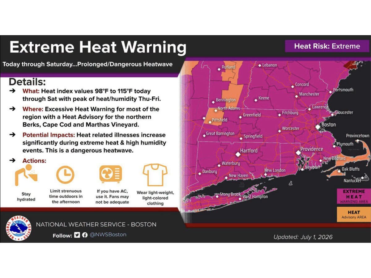
A heat wave is bringing dangerous temperatures to the state for the next several days, according to meteorologists.

Dangerous heat, high humidity and almost daily thunderstorms are in the forecast for Connecticut through the weekend, according to meteorologists.
The National Weather Service said the heat and humidity will develop Wednesday afternoon and continue through Saturday.
An extreme heat warning is now in effect and lasts until 8 p.m. Saturday for northern Connecticut. For southern counties, the warning lasts until Friday night, with an extreme heat watch through late Saturday.
Find out what's happening in Across Connecticutfor free with the latest updates from Patch.
On Thursday and Friday, the heat index will reach 100 and 115 degrees. The temperature, combined with humidity, could result in heat-related illnesses, meteorologists said.
“This has potential to be a multi-day extreme heat event with near record high temperatures and little overnight relief,” the National Weather Service said. “This level of heat can be deadly for those without adequate cooling and hydration.”
Find out what's happening in Across Connecticutfor free with the latest updates from Patch.
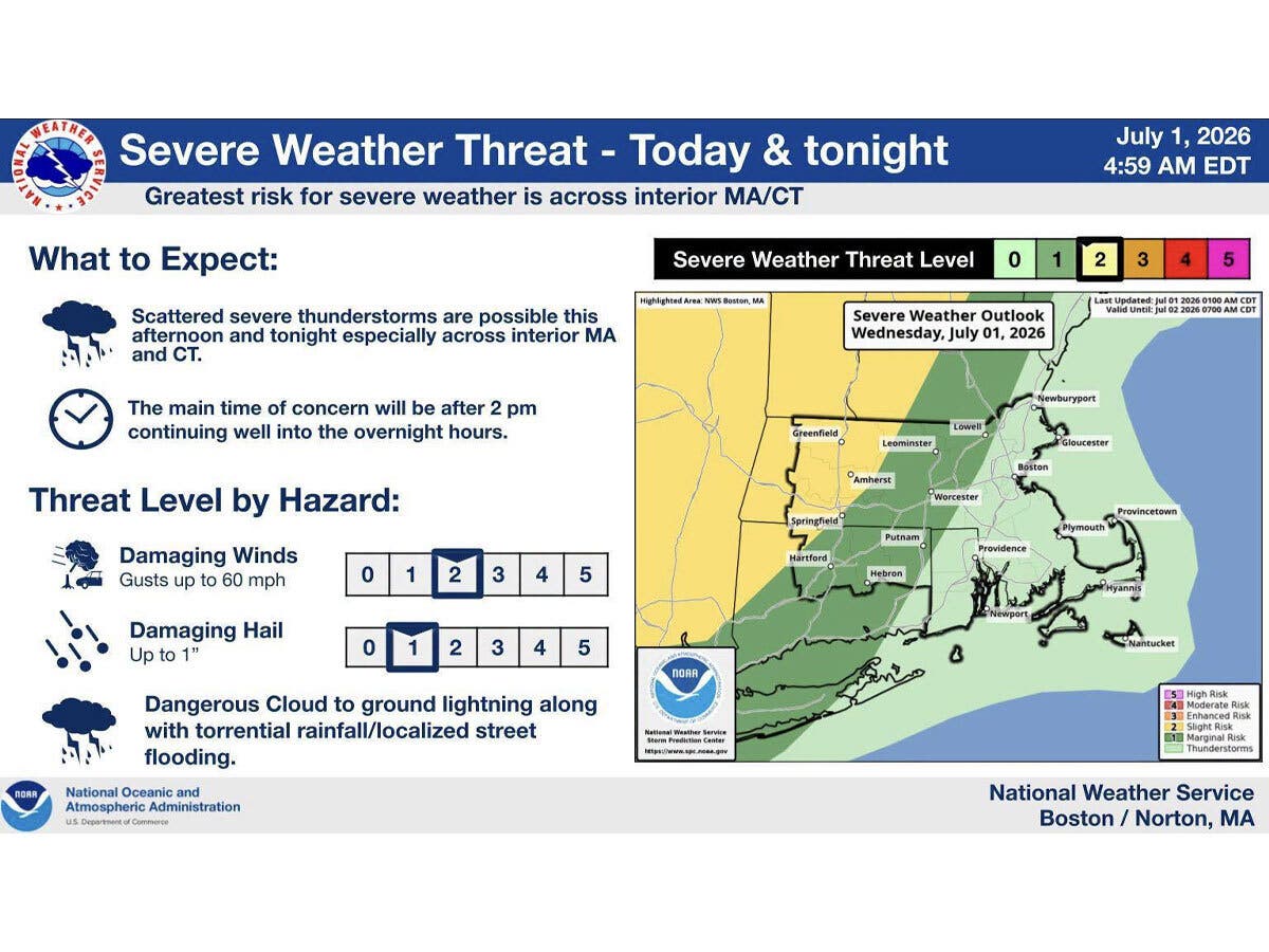
High thunderstorm risk
The first chance for storms arrives this afternoon and tonight, when there is a potential for severe thunderstorms. The greatest risk is for interior Connecticut, with the likeliest timeframe after 2 p.m. and overnight, according to the National Weather Service.
Storms could potentially bring damaging winds, hail and lightning, the National Weather Service said.
Looking ahead, it predicts that “isolated to scattered thunderstorms are possible nearly every afternoon/evening through the weekend.”
Meanwhile, an air quality alert is in effect today until 11 p.m. due to ground level ozone.
"Extreme heat is dangerous on its own, but when air quality declines at the same time, the health risks multiply," said Connecticut Department of Public Health Commissioner Manisha Juthani. "For your safety, stay indoors during peak heat hours, stay hydrated, and if you notice any difficulty breathing, chest tightness, or worsening respiratory symptoms, seek medical attention right away."
Gov. Ned Lamont has activated Connecticut's Extreme Hot Weather Protocol through at least Sunday. Cooling centers are available statewide. To find the nearest location, visit www.211ct.org or call 2-1-1.
Here are the forecast details for northern Connecticut via the National Weather Service:
Today: A chance of showers and thunderstorms, mainly after 11 a.m. Partly sunny and hot, with a high near 97. Heat index values as high as 106. Southwest wind around 9 mph. Chance of precipitation is 40%.
Tonight: A chance of showers and thunderstorms, mainly before 5 a.m. Mostly cloudy, with a low around 74. South wind 6 to 9 mph. Chance of precipitation is 30%. New rainfall amounts of less than a tenth of an inch, except higher amounts possible in thunderstorms.
Thursday: A slight chance of showers and thunderstorms before 8 a.m. Mostly sunny and hot, with a high near 102. Heat index values as high as 114. West wind 5 to 9 mph, with gusts as high as 20 mph. Chance of precipitation is 20%.
Thursday Night: Mostly clear, with a low around 75. West wind 3 to 7 mph.
Friday: Mostly sunny and hot, with a high near 101. West wind 7 to 11 mph, with gusts as high as 23 mph.
Friday Night: Mostly clear, with a low around 75. West wind 5 to 8 mph becoming calm after midnight.
Independence Day: A chance of showers and thunderstorms after 5 p.m. Mostly sunny and hot, with a high near 95. Light west wind increasing to 5 to 10 mph in the morning. Winds could gust as high as 20 mph. Chance of precipitation is 30%.
Saturday Night: A chance of showers and thunderstorms before 8 p.m., then a chance of showers between 8 p.m. and 9 p.m. Partly cloudy, with a low around 71. West wind around 6 mph becoming light and variable in the evening. Chance of precipitation is 30%.
Sunday: A chance of showers between 1 p.m. and 2 p.m., then a chance of showers and thunderstorms after 2 p.m. Partly sunny and hot, with a high near 91. North wind 3 to 5 mph. Chance of precipitation is 40%.
Sunday Night: A chance of showers and thunderstorms before 9 p.m., then showers likely and possibly a thunderstorm between 9 p.m. and 2 a.m., then showers likely after 2 a.m. Mostly cloudy, with a low around 66. South wind 3 to 5 mph. Chance of precipitation is 60%.
Here are the forecast details for southern Connecticut via the National Weather Service:
Today: Sunny, with a high near 92. Heat index values as high as 101. Southwest wind 9 to 11 mph.
Tonight: A 20 percent chance of showers and thunderstorms before 2 a.m. Partly cloudy, with a low around 73. Southwest wind 5 to 8 mph.
Thursday: Sunny, with a high near 99. Heat index values as high as 111. Light southwest wind increasing to 5 to 9 mph in the morning.
Thursday Night: Mostly clear, with a low around 76. Southwest wind 5 to 8 mph becoming calm in the evening.
Friday: A 20 percent chance of showers and thunderstorms after 2 p.m. Sunny and hot, with a high near 100. Calm wind becoming west 5 to 8 mph in the morning.
Friday Night: Mostly clear, with a low around 73.
Independence Day: A 40 percent chance of showers after 2 p.m. Mostly sunny, with a high near 97.
Saturday Night: A 40 percent chance of showers before 2 a.m. Mostly cloudy, with a low around 71.
Sunday: A 50 percent chance of showers and thunderstorms after 2 p.m. Partly sunny, with a high near 88.
Sunday Night: A chance of showers and thunderstorms before 8 p.m., then showers likely and possibly a thunderstorm between 8 p.m. and 2 a.m., then a chance of showers after 2 a.m. Mostly cloudy, with a low around 68. Chance of precipitation is 60%.
Get more local news delivered straight to your inbox. Sign up for free Patch newsletters and alerts.