Weather
Thunderstorms Expected For 4th Of July Weekend: Latest Forecast Details
It will feel like 100-plus degrees in Connecticut this week, and there are several chances of thunderstorms, including on July 4.

Dangerous levels of heat and humidity are expected as the week progresses, with multiple chances for thunderstorms, according to meteorologists.
The National Weather Service predicts today will be sunny and hot, with highs in the low to high 80s.
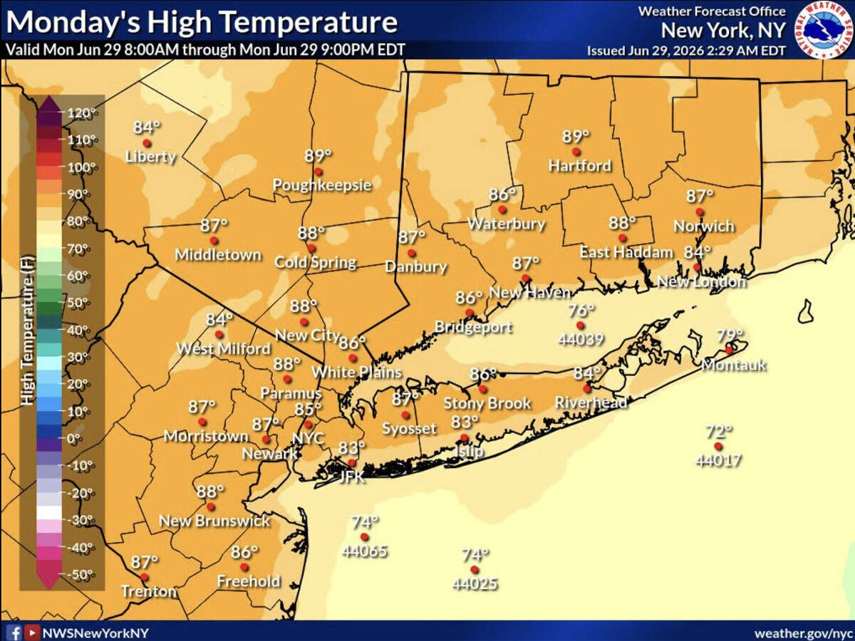
Forecasters say the heat and humidity will increase throughout this week.
Find out what's happening in Across Connecticutfor free with the latest updates from Patch.
Conditions will reach “dangerous levels by the middle and end of the week,” the National Weather Service said.
An extreme heat watch is in effect starting Wednesday afternoon and lasting through Friday evening. The National Weather Service predicts heat index values in Connecticut of between 100 and 111, with the lower amounts near the shore.
Find out what's happening in Across Connecticutfor free with the latest updates from Patch.
“Heat indices may climb above 100F and overnight temperatures may not fall below 70F, providing little recovery from daytime heat and humidity,” the National Weather Service said.
The National Weather Service predicts a chance for showers and thunderstorms Tuesday and Wednesday.
The chance for heat-related illnesses will increase significantly this week. To stay healthy, stay in air conditioning when possible and drink plenty of fluids. When outside, try to stay out of the sun, the National Weather Service advises.
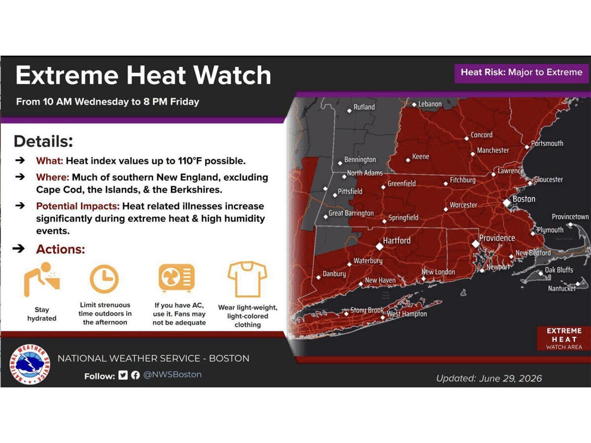
WFSB is calling Wednesday through Saturday “First Alert Weather Days” due to the “dangerous” combination of high heat and humidity.
“Air conditioning will be a necessity!” WFSB reports.
The station is forecasting record-breaking heat on Thursday, as it predicts 100 degrees for the Hartford area.
WTNH predicts actual temperatures will be in the 90s to around 100 degrees, with heat indexes between 98 and 110 for much of the state.
“Hydrate & prepare for a tough stretch ahead!” WTNH advises.
Holiday weekend
The National Weather Service says Independence Day will be mostly sunny and hot, with high temperatures in the 90s, and a chance for showers and thunderstorms.
WFSB reports the Fourth of July weekend will still be hot, with temperatures in the mid-90s inland and around 90 at the coast. The station anticipates heat index values for Saturday will be in the 95 to 100 range.
“The sky will likely feature more cloud cover and, as we see it now, there is a higher risk for scattered storms,” WFSB reports.
WTNH predicts the Fourth of July will feature hazy sun, with highs in the 90s, and late day and evening thunderstorms.
For Sunday, there is a potential cold front, which could mean storms, according to WFSB.
Read More:
- Prominent Restaurant Announces Closure
- Top Elected Official Overpaid Nearly $10K, Town Says
- Wayward Golf Balls Cause Issues At Local Business
Here are the forecast details for northern Connecticut via the National Weather Service:
Today: Sunny, with a high near 89. Calm wind becoming north around 6 mph in the afternoon.
Tonight: Mostly clear, with a low around 63. South wind 3 to 6 mph.
Tuesday: Mostly sunny and hot, with a high near 90. Light south wind becoming southwest 5 to 10 mph in the morning.
Tuesday Night: Mostly cloudy, with a low around 68. South wind around 10 mph, with gusts as high as 20 mph.
Wednesday: A slight chance of showers after 3 p.m. Mostly sunny and hot, with a high near 98. Southwest wind 7 to 9 mph. Chance of precipitation is 20%.
Wednesday Night: Partly cloudy, with a low around 74. South wind 5 to 7 mph.
Thursday: Sunny and hot, with a high near 102. West wind 5 to 11 mph.
Thursday Night: Mostly clear, with a low around 76. West wind 5 to 7 mph becoming calm after midnight.
Friday: Sunny and hot, with a high near 101. Light west wind increasing to 8 to 13 mph in the morning.
Friday Night: Partly cloudy, with a low around 72. West wind 3 to 7 mph.
Independence Day: A chance of showers and thunderstorms. Mostly sunny and hot, with a high near 97. Calm wind becoming west 5 to 9 mph in the afternoon. Chance of precipitation is 30%.
Saturday Night: A chance of showers and thunderstorms. Mostly cloudy, with a low around 68. Southwest wind 5 to 8 mph becoming light and variable in the evening. Chance of precipitation is 40%.
Sunday: A chance of showers and thunderstorms. Mostly sunny and hot, with a high near 91. Calm wind becoming southwest 5 to 7 mph in the afternoon. Chance of precipitation is 40%.
Here are the forecast details for southern Connecticut via the National Weather Service:
Today: Patchy fog before 9 a.m. Otherwise, sunny, with a high near 86. Calm wind becoming south around 6 mph in the afternoon.
Tonight: Mostly clear, with a low around 64. South wind around 6 mph becoming calm in the evening.
Tuesday: Mostly sunny, with a high near 86. Light southwest wind becoming south 6 to 11 mph in the morning.
Tuesday Night: A 20 percent chance of showers and thunderstorms. Partly cloudy, with a low around 68. Southwest wind around 8 mph.
Wednesday: A 20 percent chance of showers and thunderstorms after 2 p.m. Mostly sunny, with a high near 92. Southwest wind 9 to 11 mph.
Wednesday Night: Partly cloudy, with a low around 73.
Thursday: Sunny, with a high near 97.
Thursday Night: Mostly clear, with a low around 75.
Friday: Sunny, with a high near 97.
Friday Night: A chance of showers between 8 p.m. and 2 a.m. Partly cloudy, with a low around 73. Chance of precipitation is 30%.
Independence Day: A 40 percent chance of showers and thunderstorms. Mostly sunny, with a high near 92.
Saturday Night: A 40 percent chance of showers and thunderstorms. Mostly cloudy, with a low around 70.
Sunday: A 40 percent chance of showers. Mostly sunny, with a high near 86.
Get more local news delivered straight to your inbox. Sign up for free Patch newsletters and alerts.