Weather
2 Areas Tracked For Tropical Development: What This Means For FL
An area in the Gulf is being monitored for potential tropical development, while a system near Bermuda could strengthen, forecasters said.


Days after the 2026 Atlantic hurricane season set a satellite-era record with no hurricanes forming so far this year, forecasters are watching two areas for potential tropical development.
There have been just five named tropical storms — the most recent being Edouard, which made landfall in Louisiana on Sept. 1. — and no hurricanes so far this season.
Prior to this year, the latest occurrences of a first hurricane happened in the 2002 and 2013 seasons on Sept. 11, when Gustav and Humberto formed on that date in those years, respectively.
Find out what's happening in Tampafor free with the latest updates from Patch.
“2026 is now officially the quietest hurricane season in the Atlantic on record through Sept. 11," Fox 35 meteorologist Noah Bergen wrote in a social media post that day. “El Niño has a major impact!”
The El Niño climate pattern develops in the Pacific but can influence weather patterns around the globe. In the Atlantic, El Niño typically increases vertical wind shear, making it more difficult for tropical systems to organize and strengthen.
Find out what's happening in Tampafor free with the latest updates from Patch.
At the same time, a 3,000-mile cloud of Saharan dust is heading toward Florida and the Gulf, rare for this time of year, and should reach the Sunshine State early this week, Fox 35 forecasters said.
Though there are no areas ripe for immediate tropical development, forecasters have identified two spots to monitor in the coming weeks.
As of Monday morning, a trough of low pressure about 1,000 miles southeast of Bermuda has a 40 percent chance of strengthening into a tropical depression or storm over the next week, as it moves west across the Atlantic, the National Hurricane Center said.
The next named storm of the season is Fay.
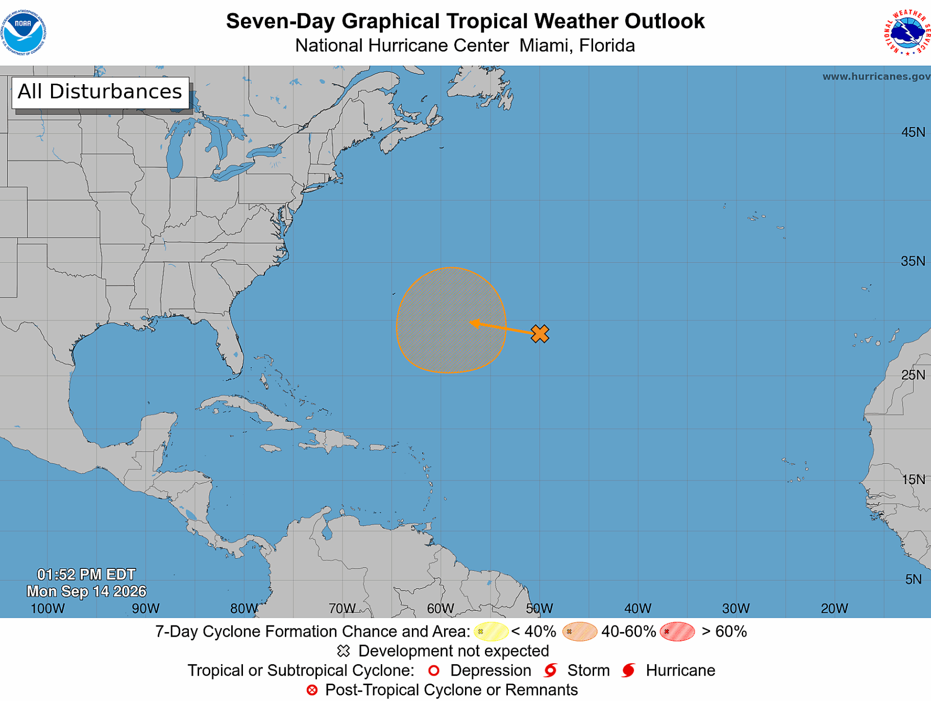
This system is currently producing disorganized showers and thunderstorms.
“Environmental conditions over the system are currently unfavorable for development due to strong upper-level winds. However, as the system moves west-northwestward across the central part of the Subtropical Atlantic, it is forecast to enter a more conducive environment for gradual development by the middle to latter portion of this week,” NHC forecasters said.
The system won’t affect the Sunshine State, whether it develops or not, Denis Phillips, chief meteorologist for Tampa Bay 28, wrote in a social media post.
“Even if storm formation does happen here, this system is not a threat to Florida and would most likely turn away from the United States,” Phillips wrote.
AccuWeather forecasters have highlighted “a congestion of showers and thunderstorms … in the waters of the northern and eastern Gulf,” near Florida, as an area for potential tropical development.
“This is the main area where wind shear is weaker and moisture is more abundant,” AccuWeather said.
This spot has low chances of development from Sept. 17-19, forecasters said.
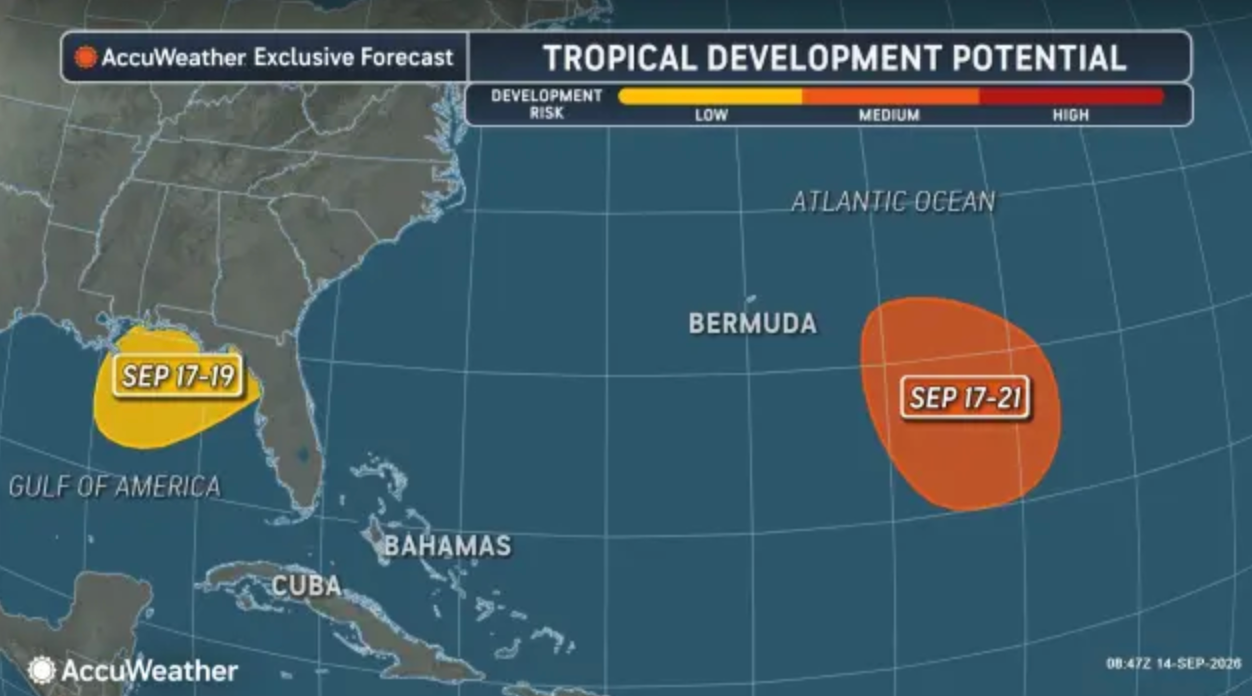
“The Gulf Coast is a common resting place for fronts that previously moved into the region from the north and west. Tropical development can occasionally occur along these decaying frontal boundaries. An upper-level storm is forecast to form off the mid-Atlantic coast early this week, drift southwest across the Southeast and enter the Gulf by the weekend,” according to AccuWeather.
“Stronger high pressure building southward from the eastern United States will lead to increasing NE to E winds over the basin [starting late Tuesday,] with speeds reaching fresh to strong and rough seas over the northern Gulf Wednesday through Thursday night,” NHC forecasters said. “Conditions will improve Friday.”
While these upper-level storms could lead to tropical development, early forecasts call for this system to keep moving, rather than stall, which will generate disruptive wind shear in its path, AccuWeather said.
Get more local news delivered straight to your inbox. Sign up for free Patch newsletters and alerts.