Weather
3 Areas Eyed For Tropical Development In Atlantic: What This Means For FL
The tropics have come alive, with three areas in the Atlantic being watched for potential tropical development, according to the NHC.


After a slow start to the 2026 Atlantic hurricane season, the tropics came alive over the weekend, with forecasters watching three systems for potential development as of Monday morning, according to the National Hurricane Center.
“Things are perking up in both the Atlantic and Pacific, though it's all just potential right now with no active systems,” Fox 35 meteorologist Noah Bergren wrote in a social media post.
These areas popped up on the radar over the past couple of days, just after the National Oceanic and Atmospheric Administration slightly downgraded its predictions for the season, lowering its expectations for named storms to somewhere between seven and 13 this year. This is down from NOAA's original forecast of eight to 14 named storms.
Find out what's happening in Tampafor free with the latest updates from Patch.
While watching these three new areas of interest, some experts think we could see the third named storm of the year, Cristobal, form, though conditions aren’t favorable for them to strengthen, forecasters said.
As experts watch these systems for development, it’s too soon to say with certainty what’s in store for Florida, though they think there’s likely no threat to the Sunshine State.
Find out what's happening in Tampafor free with the latest updates from Patch.
“Lots to watch and track, but the overall tropical threat remains low,” Fox 13’s Paul Dellegatto wrote in a social media post.
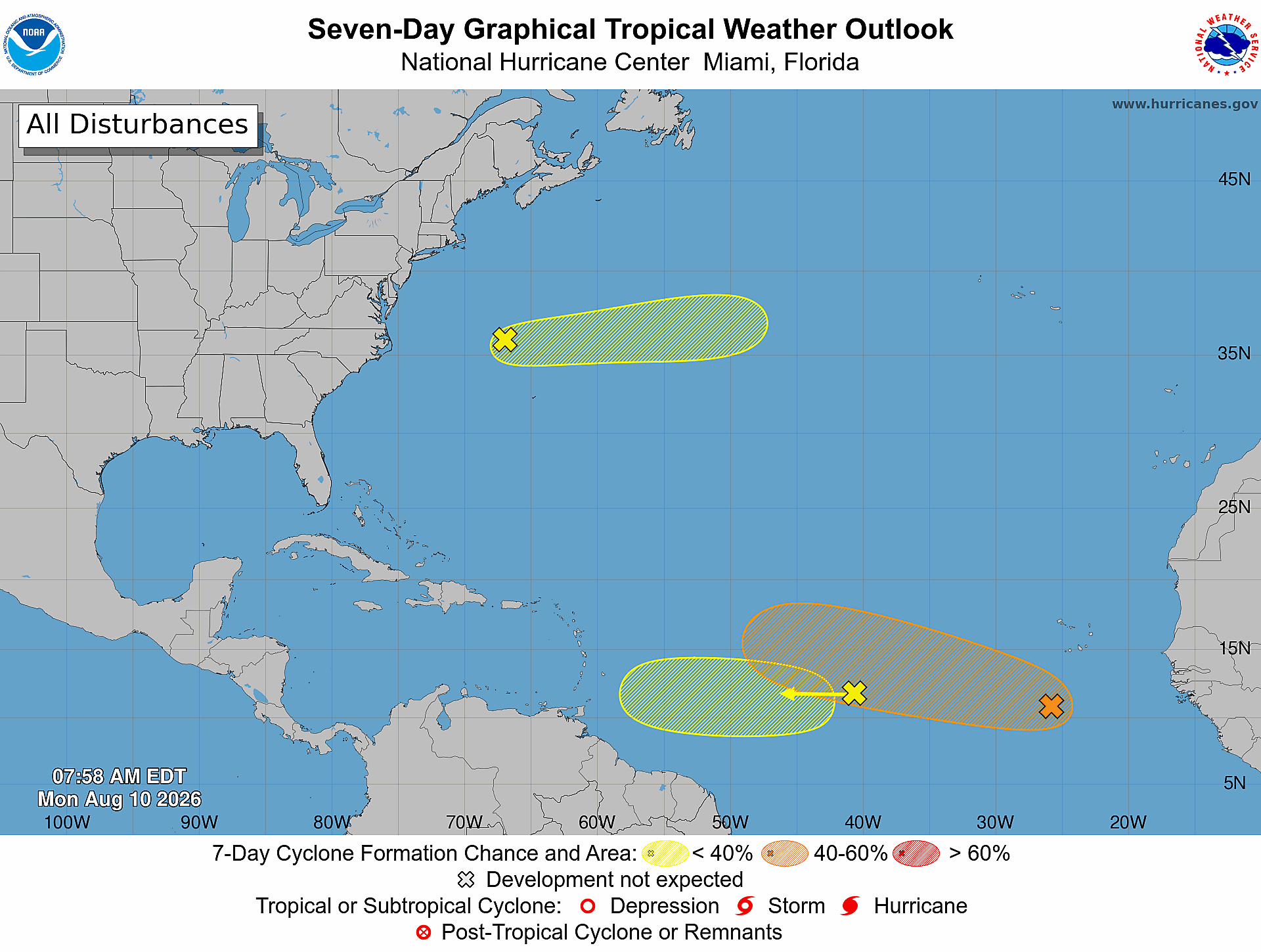
One area of low pressure, a few hundred miles south of the Cabo Verde Islands, is expected to merge with a tropical wave over west Africa as it moves west over the next couple of days, NHC forecasters said.
This system has a 60 percent chance of developing over the next seven days, the agency said.
“Environmental conditions are forecast to be more conducive for development by midweek, and a tropical depression could form during the latter half of this week while the system moves westward to west-northwestward across the central tropical Atlantic,” the NHC said.
Bergen wrote, “We may get a brief tropical storm (Cristobal) later this week, but hostile wind shear should kill it off quickly. Plus, the path looks to curve safely away from the U.S. even if it over performs and stays a system longer.”
Denis Phillips, chief meteorologist for Tampa Bay 28, wrote in a social media post, “...it's very possible we get our next system to track here by the end of the week. Nothing to worry about for Florida.”
Dellegatto agreed, writing in a social media post, that the area “has a decent chance of becoming a named storm, but more than likely, it will head towards the open Atlantic.”
Another broad area of showers and thunderstorms associated with a tropical wave about halfway between the coast of west Africa and the Lesser Antilles has just a 10 percent chance of developing into a tropical depression over the next week, the NHC said.
While some gradual development is possible by mid-week, as it moves west across the central tropical Atlantic, upper-level winds are expected to keep it from strengthening as it approaches the Lesser Antilles, forecasters said.
This area “likely will not yield any system,” Bergren wrote.
Though it’s poised to head toward the Caribbean, the system “will likely fizzle out as it moves into a hostile environment,” Dellegatto wrote.
A third area being watched, a trough of low pressure a few hundred miles northwest of Bermuda, is producing disorganized showers and thunderstorms as of Monday morning, the NHC said.
This area “off the Carolina coast is heading out to see,” Dellegatto wrote.
While some development is possible, the system is expected to hit cooler waters later this week as it moves east, “ending its chances of formation after Wednesday,” the agency said.
Get more local news delivered straight to your inbox. Sign up for free Patch newsletters and alerts.