Weather
Flash Flooding, Tornadoes, Damaging Hail Possible With Monday Storms In Chicago Area
A look at the timeline for Monday's severe weather, a day after storms flooded roadways in the suburbs.


Another round of thunderstorms is possible Monday afternoon through Monday night, and some storms could be severe, according to the National Weather Service.
The stormy weather pattern will continue all week, although plenty of dry hours are still expected.
The severe weather threat on Monday could bring storms with damaging winds and hail, as well as a flash flooding threat. The weather service said a threat for tornadoes cannot be ruled out for Monday afternoon and evening.
Find out what's happening in Across Illinoisfor free with the latest updates from Patch.
The flood threat comes a day after heavy rain and storms flooded roads in the Chicago area, leaving drivers stranded in the west suburbs.
When Severe Weather Could Hit
According to the National Weather Service, the primary window for the greatest storm threat is from 3 p.m. Monday through 5 a.m. Tuesday.
Find out what's happening in Across Illinoisfor free with the latest updates from Patch.
Soaking downpours, lightning strikes and gusty winds are possible.
Residents are urged to use caution when driving in heavy rain and "turn around, don't drown" if they come across flooded roads.
Torrential rains may cause flooding of roads, low-lying areas, fields and basements, as well as causing rapidly rising water levels in area bodies of water.
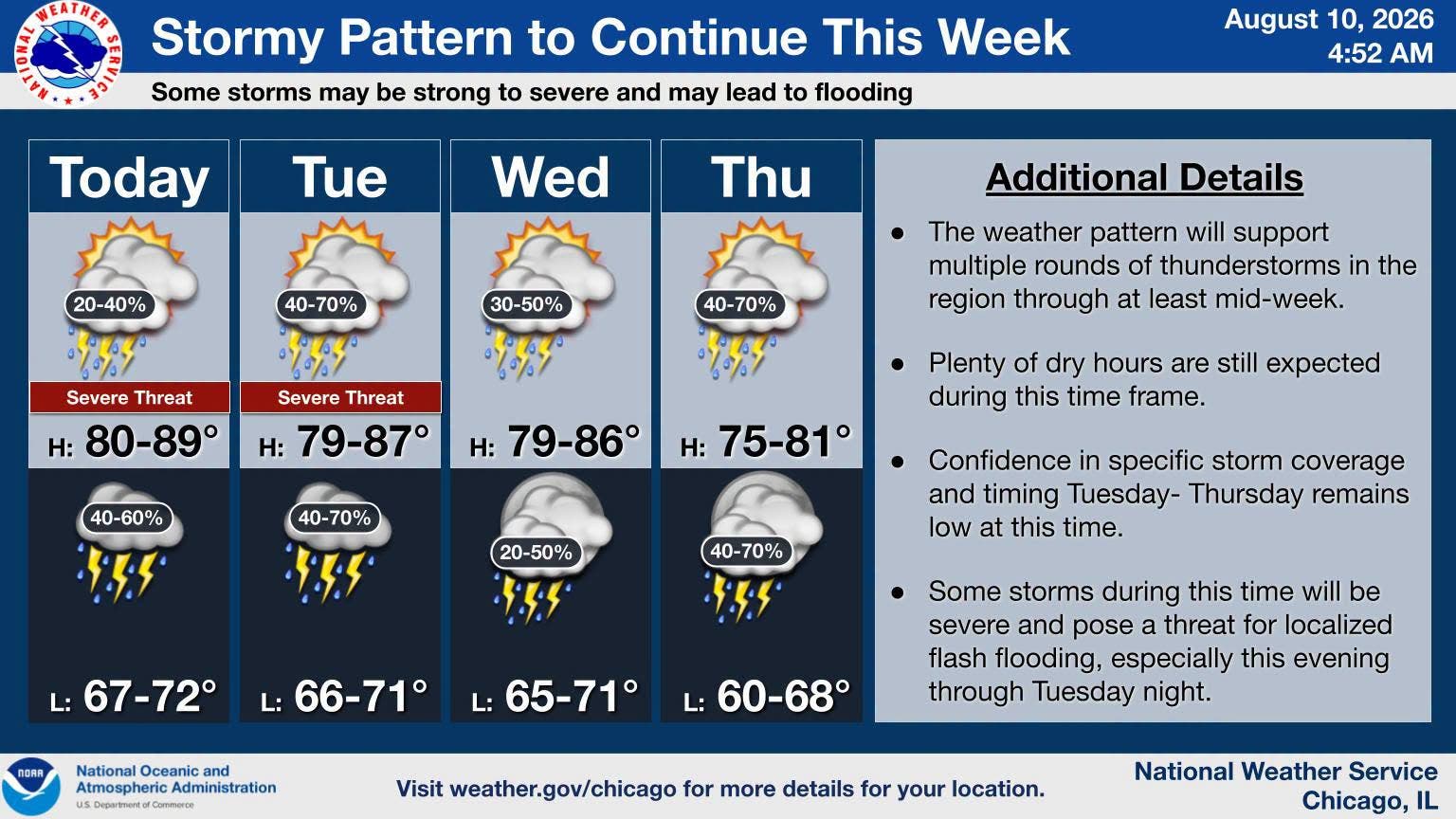
Stormy Week Ahead Possible
According to the weather service, additional rounds of storms are possible through mid-week, with a "continued threat of flash flooding and severe weather at times, especially Tuesday and Tuesday night."
Tuesday has a potential for storms to develop "into an organized line or bow capable [of] producing destructive winds," the weather service. However, the exact coverage of storms in northern Illinois is still uncertain.
Storm chances continue for the rest of the week. The weather service said there is a limited thunderstorm risk on Wednesday, Thursday, Friday, Saturday and Sunday.
Here is a more detailed look at the weather for this week for the Joliet area, per the weather service:
MONDAY: A slight chance of showers, then a chance of showers and thunderstorms after 9 a.m. Partly sunny, with a high near 85. Southwest wind around 5 mph. Chance of precipitation is 30%.
MONDAY NIGHT: A 40 percent chance of showers and thunderstorms. Mostly cloudy, with a low around 69. East wind around 5 mph.
TUESDAY: A 50 percent chance of showers and thunderstorms, mainly after 8am. Mostly cloudy, with a high near 83. Southeast wind around 5 mph becoming west in the afternoon. Winds could gust as high as 10 mph.
TUESDAY NIGHT: Showers likely and possibly a thunderstorm. Mostly cloudy, with a low around 69. East northeast wind around 5 mph. Chance of precipitation is 60%.
WEDNESDAY: A chance of showers before 1 p.m., then a chance of showers and thunderstorms between 1 p.m. and 4 p.m., then a chance of showers after 4 p.m. Partly sunny, with a high near 84. Northeast wind around 5 mph becoming west northwest in the afternoon. Winds could gust as high as 10 mph. Chance of precipitation is 40%.
WEDNESDAY NIGHT: A 20 percent chance of showers before 1 a.m. Partly cloudy, with a low around 69.
THURSDAY: A chance of showers, with thunderstorms also possible after 1 p.m. Mostly cloudy, with a high near 80. Chance of precipitation is 50%.
THURSDAY NIGHT: A chance of showers. Mostly cloudy, with a low around 65.
FRIDAY: A chance of showers and thunderstorms before 1 p.m. Mostly cloudy, with a high near 77.
FRIDAY NIGHT: A chance of showers after 1 a.m. Mostly cloudy, with a low around 64.
Get more local news delivered straight to your inbox. Sign up for free Patch newsletters and alerts.