Weather
Tornado, Severe Storm Risk For Chicago Area: Here's When It Will Hit
The risk of severe weather brings a tornado threat as poor air quality continues in Chicagoland.


Poor air quality has returned to the Chicago area, and it will continue through Monday, especially Monday morning, according to the National Weather Service.
There is an air quality alert in effect across the Chicago area due to wildfire smoke. The weather service advises reducing long or intense outdoor activities.
RELATED: Wildfire Smoke Over IL: What Residents Need To Know About Air Quality
Find out what's happening in Across Illinoisfor free with the latest updates from Patch.
In addition to the poor air quality, there is a possibility for severe storms on Monday. Scattered storms are likely Monday evening into the early overnight hours, the weather service said.
"While not every area will see storms, where storms do occur some could be severe with damaging winds the primary threat," the weather service said. Hail is also possible, as well as torrential rainfall.
Find out what's happening in Across Illinoisfor free with the latest updates from Patch.
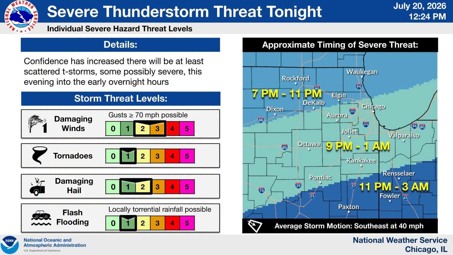
Confidence has increased that at least scattered storms will happen, the weather service said. Storms would be possible for the DeKalb, Elgin and Waukegan areas from 7 to 11 p.m.; and for Aurora, Chicago, Joliet and Kankakee between 9 p.m. and 1 a.m.
After Monday, the forecast looks dry and sunny for the rest of the week. Temps look to cool off later this week, with a high of 87 on Monday, 86 on Tuesday, 77 on Wednesday, 80 on Thursday and 84 on Friday, according to the current forecast.
Here is a more detailed look at the weather this week, per the weather service:
MONDAY: Isolated showers and thunderstorms before 1 p.m., then isolated showers and thunderstorms after 4 p.m. Widespread smoke before 1 p.m. Partly sunny, with a high near 86. Southwest wind 5 to 15 mph, with gusts as high as 25 mph. Chance of precipitation is 20%.
MONDAY NIGHT: Scattered showers and thunderstorms, mainly after 1am. Mostly cloudy, with a low around 72. South southwest wind 10 to 15 mph, with gusts as high as 25 mph. Chance of precipitation is 50%.
TUESDAY: Mostly sunny, with a high near 85. West northwest wind 10 to 15 mph, with gusts as high as 25 mph.
TUESDAY NIGHT: Partly cloudy, with a low around 60. North wind 10 to 15 mph, with gusts as high as 25 mph.
WEDNESDAY: Sunny, with a high near 74. North wind around 10 mph, with gusts as high as 15 mph.
WEDNESDAY NIGHT: Mostly clear, with a low around 58.
THURSDAY: Sunny, with a high near 79.
THURSDAY NIGHT: Partly cloudy, with a low around 61.
FRIDAY: Mostly sunny, with a high near 82.
FRIDAY NIGHT: Partly cloudy, with a low around 64.
Get more local news delivered straight to your inbox. Sign up for free Patch newsletters and alerts.