Weather
Tornado Watch In Effect For Chicago Area
Flood warnings were also in effect in several parts of the suburbs.

A tornado watch is in effect until 11 p.m. for counties including Cook, DuPage, Lake, Kane, Kendall and Grundy, the National Weather Service said.
A tornado watch was also in place until 8 p.m. for areas including DeKalb and McHenry counties, affecting Algonquin, Crystal Lake, McHenry, Woodstock and other towns.
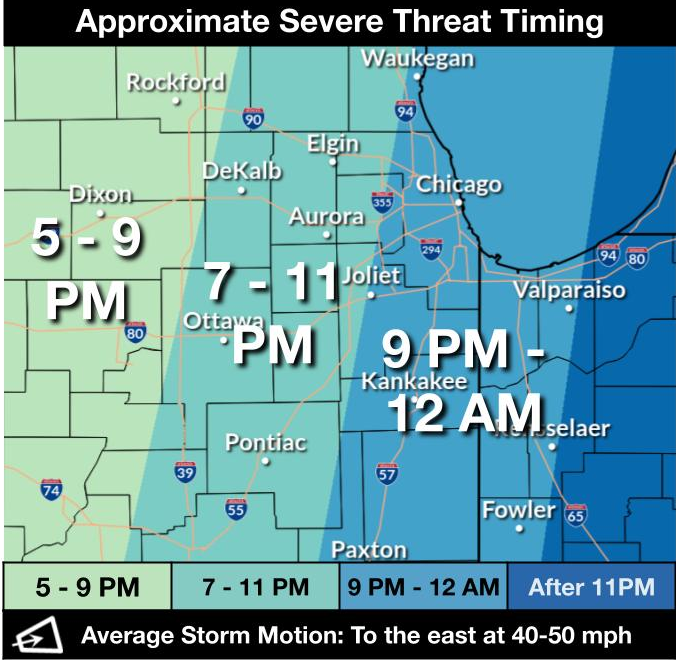
Severe weather Friday night could include damaging winds, hail and a few tornadoes also possible, according to the National Weather Service.
Find out what's happening in Across Illinoisfor free with the latest updates from Patch.
The timing for the severe weather varies, with the storms moving west to east (between 40 to 50 mph) starting at 5 p.m. in the Rockford area and eventually hitting Chicago between 9 p.m. and midnight.
Residents are urged to have multiple ways to get weather warnings and to stay tuned for the latest updates.
Find out what's happening in Across Illinoisfor free with the latest updates from Patch.
In addition to the severe weather, flash flooding continues to disrupt things, especially along the Des Plaines River. NWS said the greatest flooding threat is expected near the Illinois-Wisconsin line, where rainfall has been the highest this past week, though localized flooding could occur anywhere storms train.
Flood warnings were in effect for the Fox River at Montgomery, affecting Kendall and Kane counties, as well as at Algonquin Lock & Dam affecting Lake, Kane and McHenry counties.
- RELATED: Des Plaines Prepares For Flooding Along River As City Warns Of Delays
- Flooding Closes Park, Fox River Levels Expected To Rise Through Next Week
NWS is predicting the severe weather conditions to taper down Friday night, with cooler and drier conditions in the forecast for the weekend. Frost and sub-freezing temperatures are possible for some areas Saturday and Sunday nights.
Here is a look at the detailed weekend forecast courtesy of NWS:
FRIDAY
Mostly sunny, with a high near 81. Breezy, with a south wind 10 to 20 mph, with gusts as high as 30 mph.
FRIDAY NIGHT
Showers and thunderstorms before 5 a.m., then a chance of showers. Low around 44. Breezy, with a south wind 15 to 20 mph becoming west after midnight. Winds could gust as high as 30 mph. Chance of precipitation is 100 percent New rainfall amounts between a half and three-quarters of an inch possible.
SATURDAY
A 20 percent chance of showers before 10 a.m. Cloudy, then gradually becoming mostly sunny, with a steady temperature around 48. Breezy, with a west-northwest wind 15 to 20 mph, with gusts as high as 30 mph.
SATURDAY NIGHT
Mostly clear, with a low around 36. West-northwest wind 10 to 15 mph, with gusts as high as 25 mph.
SUNDAY
Mostly sunny, with a high near 50. West-northwest wind 10 to 15 mph, with gusts as high as 25 mph.
SUNDAY NIGHT
Areas of frost after 5am. Otherwise, mostly clear, with a low around 35.
Get more local news delivered straight to your inbox. Sign up for free Patch newsletters and alerts.