Weather
Storm Chances Return Later This Week To Chicago Area
After days of "incredible" rainfall, storm chances return Thursday.


Cooler temperatures have returned to the Chicago area, and will stick around through the middle of the week, according to the National Weather Service.
Monday has a high of 82 degrees, and a "few spotty showers" are possible for part of the area. There is also a moderate swim risk at Lake Michigan beaches on Monday, the weather service said. Breaking waves to 2 to 4 feet are possible.
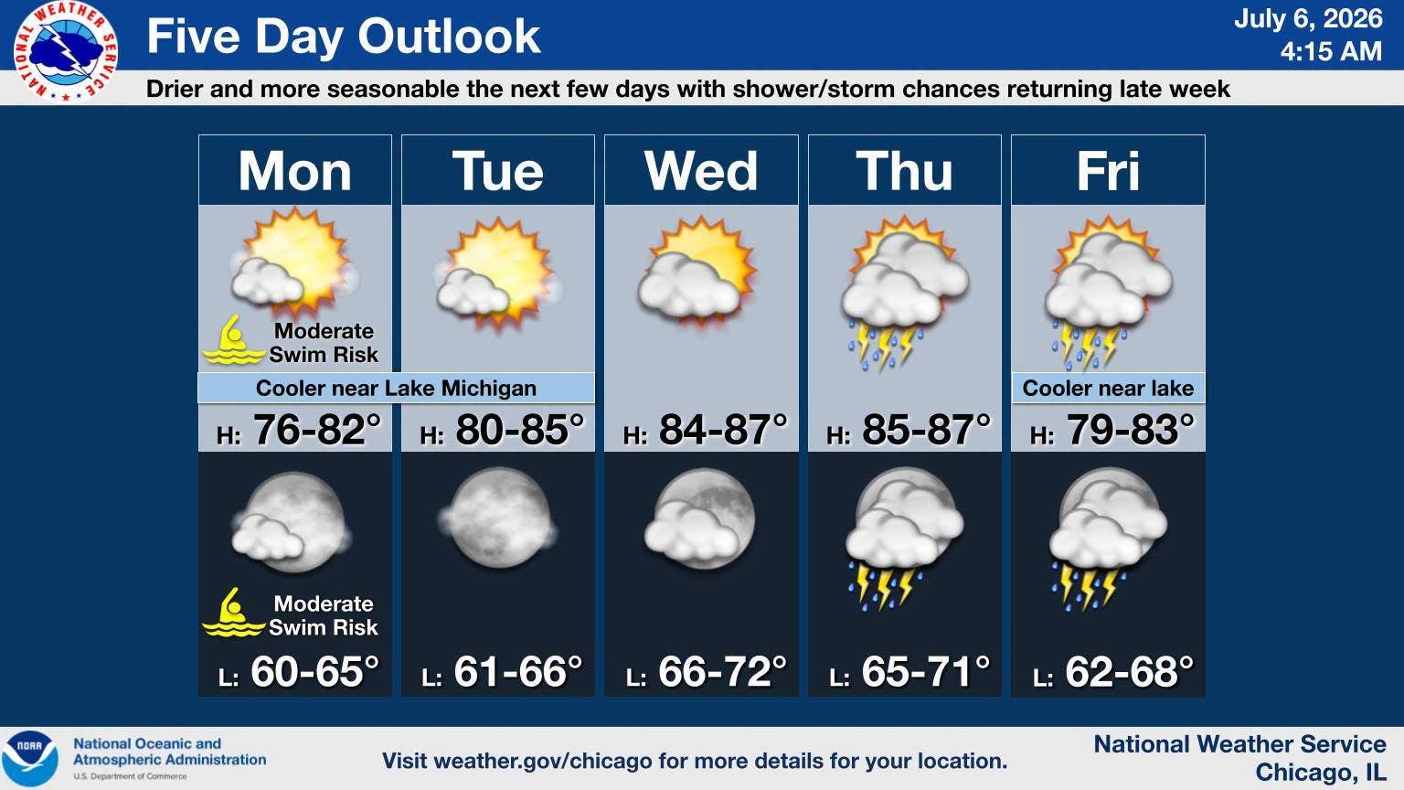
"Otherwise, dry and more seasonable conditions are expected the next few days with shower and storm chances returning later in the week," the weather service said on its Facebook.
Find out what's happening in Across Illinoisfor free with the latest updates from Patch.
The few days of dry weather comes after "incredible" rainfall amounts from July 2-4, according to the weather service. The heaviest rain fell between Interstate 80 and Interstate 88, and the highest totals were over 8 inches of rain.
The weather led to the cancellation or postponement of numerous fireworks shows throughout the Chicago area.
Find out what's happening in Across Illinoisfor free with the latest updates from Patch.
Many areas saw flash flooding and rapid rises in area rivers, the weather service said. Some of the highest rainfall amounts were:
- Sugar Grove, 8.39 inches of rain
- Aurora Airport, 9.22 inches of rain
- Oswego, 7.73 inches of rain
- Aurora, 7.54 inches of rain
- Yorkville, 6.73 inches of rain
- Flossmoor, 6.37 inches of rain
- Plano, 6.33 inches of rain
- Batavia, 5.67 inches of rain
- Lombard, 5.61 inches of rain
- Elgin, 5.16 inches of rain
- Woodridge, 5.02 inches of rain
Week ahead forecast
Here is a more detailed look at the weather for this week, per the weather service:
MONDAY: Mostly sunny, with a high near 79. Northeast wind around 10 mph, with gusts as high as 20 mph.
MONDAY NIGHT: Mostly clear, with a low around 63. Northeast wind 5 to 10 mph.
TUESDAY: Sunny, with a high near 85. North northeast wind around 5 mph.
TUESDAY NIGHT: Mostly clear, with a low around 64. East northeast wind around 5 mph becoming calm in the evening.
WEDNESDAY: Sunny, with a high near 86. Calm wind becoming southwest around 5 mph in the afternoon. Winds could gust as high as 10 mph.
WEDNESDAY NIGHT: Partly cloudy, with a low around 68.
THURSDAY: A 50 percent chance of showers and thunderstorms after 1 p.m. Mostly sunny, with a high near 87.
THURSDAY NIGHT: Showers likely and possibly a thunderstorm. Mostly cloudy, with a low around 68.
FRIDAY: A chance of showers, with thunderstorms also possible after 1 p.m. Mostly cloudy, with a high near 82.
FRIDAY NIGHT: A chance of showers and thunderstorms before 1am. Mostly cloudy, with a low around 64.
Get more local news delivered straight to your inbox. Sign up for free Patch newsletters and alerts.