Weather
Snow Possible Saturday In Algonquin, Lake In The Hills After Temps Near 60 Friday
Here is the weather forecast for Thursday through Tuesday.

ALGONQUIN AND LAKE IN THE HILLS, IL — Algonquin and Lake in the Hills-area residents will be able to ditch their winter coats — for a day.
On Friday, a high near 60 degrees is expected. There will also be high wind gusts in the forecast, which will lead to an elevated risk for brush and grass fires to spread, according to the National Weather Service.
The unseasonably mild temperatures will be short-lived as a 20-degree drop is expected as we head into the weekend.
Find out what's happening in Algonquin-Lake In The Hillsfor free with the latest updates from Patch.
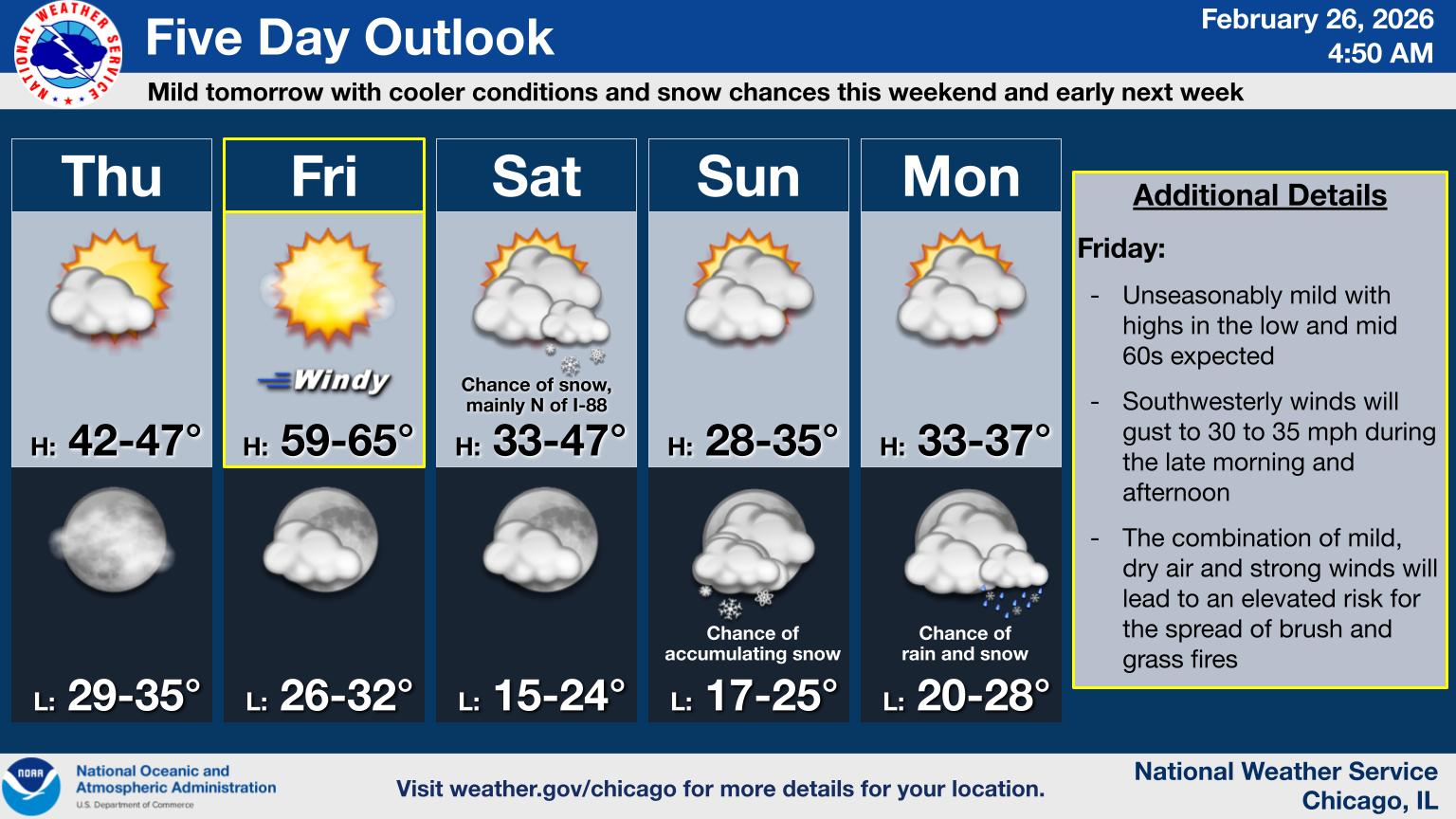
What to Expect this Weekend:
This weekend in McHenry County, expect a mix of sun and clouds, with temperatures on the cooler side, especially in the mornings. Saturday will see highs in the mid 30s, with cloudy skies and a 50 percent chance for snow — which is mainly expected in the afternoon. Sunday will be cooler, with highs in the upper-20s and partly sunny skies.
Find out what's happening in Algonquin-Lake In The Hillsfor free with the latest updates from Patch.
What to Know:
While the weekend isn’t expected to bring major snowstorms, the temperatures will remain chilly and there is a chance for some snow on Saturday afternoon, so bundle up if you plan to head outside. Road conditions could be slick in spots due to overnight freezes, particularly during the morning hours.
Stay safe and check the forecast for any updates.
Details for Algonquin, Lake in the Hills Weather Forecast Through Tuesday
- Thursday: Sunny, with a high near 42. East southeast wind 5 to 10 mph becoming southwest in the afternoon. Winds could gust as high as 20 mph. Thursday night: Mostly clear, with a low around 30. Southwest wind around 10 mph, with gusts as high as 15 mph.
- Friday: Sunny, with a high near 61. Breezy, with a southwest wind 10 to 15 mph increasing to 15 to 20 mph in the afternoon. Winds could gust as high as 35 mph. Friday Night: Increasing clouds, with a low around 27. West southwest wind 10 to 15 mph becoming north northwest after midnight. Winds could gust as high as 25 mph.
- Saturday: A 50 percent chance of snow, mainly after noon. Cloudy, with a high near 35. North northeast wind 5 to 10 mph, with gusts as high as 15 mph. Saturday Night: Mostly cloudy, with a low around 16.
- Sunday: A 20 percent chance of snow after noon. Partly sunny, with a high near 29.Sunday Night: A chance of snow before midnight. Mostly cloudy, with a low around 18.
- Monday: Mostly cloudy, with a high near 34. Monday Night: Mostly cloudy, with a low around 22.
- Tuesday: A chance of rain. Mostly cloudy, with a high near 42. Tuesday Night: Mostly cloudy, with a low around 26.
Get more local news delivered straight to your inbox. Sign up for free Patch newsletters and alerts.