Weather
MD Kicks Off September With Record-Setting Heat, Fresh Round Of Storms
The first week of September will bring storms and feels-like temperatures in the 100s for Marylanders. Here's what you can expect this week.


Residents in Maryland will kick down the door to September with a fresh round of storms and record-setting temperatures this week.
Forecasters say the heat dome that enveloped much of the West Coast last week is now bringing sizzling temperatures to residents on the East Coast.
Between the heat and humidity, heat index values could soar past 100 degrees.
Find out what's happening in Across Marylandfor free with the latest updates from Patch.
AccuWeather warns that temperatures could climb 10 to 15 degrees above historical averages, and that many parts of the East Coast could see their highest temperatures in the last two months.
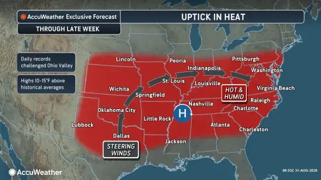
Forecasts released by the National Weather Service show that each day brings scorching temperatures in the high 90s, considered some of the hottest conditions since early July.
Find out what's happening in Across Marylandfor free with the latest updates from Patch.
"After a cool week in the mid-Atlantic, it’s a reminder that summer isn’t quite over," AccuWeather expert meteorologist Alyssa Glenny said in a statement.
"Not only will residents have to endure the heat, an influx of moisture from Gulf will also raise humidity levels, making it feel quite sticky. Some places will experience AccuWeather RealFeel temperatures as high as 110 degrees."
Storm Timeline
Rainstorms are possible every day this week, but the strongest chance for showers and thunderstorms comes Wednesday.
The latest forecasts from the National Weather Service say the next chance for rainy conditions is Monday after 9 p.m., and then again Tuesday after 2 p.m.
While both instances currently have a 20% possibility, the chance for inclement weather doubles by 2 a.m. Wednesday and then again from 8 p.m. Wednesday to 2 a.m. Thursday.
Detailed Forecast For Baltimore Region
Monday Afternoon: Partly sunny, with a high near 88. East wind around 5 mph.
Monday Night: A slight chance of showers and thunderstorms between 9 p.m. and 10 p.m. Mostly cloudy, with a low around 73. Southeast wind around 5 mph becoming calm in the evening. Chance of precipitation is 20%.
Tuesday: A slight chance of showers and thunderstorms after 2 p.m. Partly sunny, with a high near 96. Heat index values as high as 102. Calm wind becoming west 5 to 7 mph in the afternoon. Chance of precipitation is 20%.
Tuesday Night: A chance of showers and thunderstorms before 2 a.m., then a slight chance of showers between 2 a.m. and 3 a.m. Mostly cloudy, with a low around 75. Light and variable wind. Chance of precipitation is 40%.
Wednesday: A slight chance of showers and thunderstorms after 2 p.m. Partly sunny, with a high near 91. Calm wind becoming east around 6 mph in the afternoon. Chance of precipitation is 20%.
Wednesday Night: A chance of showers and thunderstorms, mainly between 8 p.m. and 2 a.m. Mostly cloudy, with a low around 74. Chance of precipitation is 40%.
Thursday: A slight chance of showers and thunderstorms after 2 p.m. Mostly sunny, with a high near 96. Chance of precipitation is 20%.
Thursday Night: A slight chance of showers and thunderstorms. Partly cloudy, with a low around 75. Chance of precipitation is 20%.
Friday: A chance of showers and thunderstorms after 2 p.m. Mostly sunny, with a high near 90. Chance of precipitation is 30%.
Friday Night: A chance of showers and thunderstorms, mainly before 8 p.m. Partly cloudy, with a low around 69. Chance of precipitation is 30%.
Saturday: Sunny, with a high near 84.
Saturday Night: Partly cloudy, with a low around 64.
Sunday: Sunny, with a high near 80.
Get more local news delivered straight to your inbox. Sign up for free Patch newsletters and alerts.