Weather
Severe Thunderstorms Inching Toward MD: See Latest Forecast, Timeline
The thunderstorms aren't done with Maryland just yet. Forecasters warn another round of severe weather is forecast to hit this week.


After a day of clear but steamy conditions, Maryland is in for another round of showers and likely severe thunderstorms this week.
While residents can expect sunny conditions and high temperatures peaking just under the 90-degree mark at the start of the work week, things take a turn come Tuesday.
Storm Timeline
Forecasters say thunderstorms will start hitting parts of Maryland around 5 a.m. Tuesday, with additional storm rounds arriving around 2 p.m. and sticking around through at least 8 p.m.
Find out what's happening in Across Marylandfor free with the latest updates from Patch.
AccuWeather reports that between a half and three-quarters of an inch of rain is possible for Tuesday.
The National Weather Service has not yet issued official alerts for the state but has said flooding could be possible Tuesday and Wednesday.
Find out what's happening in Across Marylandfor free with the latest updates from Patch.
For parts of southeast Maryland, the agency warns the threat of hazardous weather is low, but that "damaging wind gusts and heavy rainfall leading to flash flooding will be the main threats."
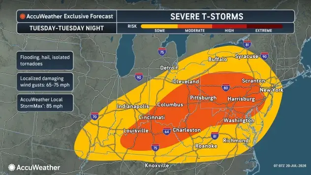
Wind gusts could reach as high as 75 mph come Tuesday, according to AccuWeather.
The stormy weather will return Wednesday around 2 p.m., but the next round of inclement conditions won't impact the region again until early Saturday, around 2 a.m.
On Thursday and Friday, Marylanders get a break from the storms as sunny conditions offer a slight reprieve. Expect the day's highest temperatures in the low 80s.
Detailed Forecast For Baltimore Region
Monday Afternoon: Mostly sunny, with a high near 88. Southeast wind around 6 mph.
Monday Night: A chance of showers and thunderstorms, then showers likely and possibly a thunderstorm after 5 a.m. Increasing clouds, with a low around 70. Southeast wind 5 to 7 mph. Chance of precipitation is 60%. New rainfall amounts of less than a tenth of an inch, except higher amounts possible in thunderstorms.
Tuesday: Showers and thunderstorms likely before 2 p.m., then showers and possibly a thunderstorm between 2 p.m and 5 p.m., then showers and thunderstorms likely after 5 p.m. High near 89. Southwest wind 5 to 10 mph. Chance of precipitation is 90%. New rainfall amounts between a half and three quarters of an inch possible.
Tuesday Night: Showers and thunderstorms likely, then showers and possibly a thunderstorm after 8 p.m. Low around 71. Southwest wind around 10 mph, with gusts as high as 21 mph. Chance of precipitation is 90%. New rainfall amounts between a half and three quarters of an inch possible.
Wednesday: Showers likely, with thunderstorms also possible after 2 p.m. Partly sunny, with a high near 88. West wind 7 to 10 mph, with gusts as high as 18 mph. Chance of precipitation is 60%.
Wednesday Night: Partly cloudy, with a low around 64.
Thursday: Sunny, with a high near 82.
Thursday Night: Mostly clear, with a low around 64.
Friday: Sunny, with a high near 84.
Friday Night: A slight chance of showers after 2 a.m. Partly cloudy, with a low around 67. Chance of precipitation is 20%.
Saturday: Mostly sunny, with a high near 86.
Saturday Night: Partly cloudy, with a low around 68.
Sunday: Mostly sunny, with a high near 89.
Get more local news delivered straight to your inbox. Sign up for free Patch newsletters and alerts.