Weather
103-Degree Heat Scorches MA As 40+ Beaches Still Closed: See Latest Forecast
A Heat Advisory is in effect across most of the state as the next major heat wave begins.


Nearly four dozen beaches remained unsafe for swimming on Tuesday as Massachusetts prepared for its latest extreme heat stretch that will send "feels-like" temperatures past 100 degrees this week.
The National Weather Service issued a Heat Advisory starting at 11 a.m. on Tuesday and lasting until 8 p.m. on Wednesday for most of the Bay State.
"Hot temperatures and high humidity may cause heat illness," the NWS said. "Drink plenty of fluids, stay in an air-conditioned room, stay out of the sun, and check up on relatives and neighbors."
Find out what's happening in Across Massachusettsfor free with the latest updates from Patch.
The Heat Index on Tuesday and Wednesday is forecast at 103 degrees.
The NWS also issued an Elevated Fire Risk for much of the state on Tuesday.
Find out what's happening in Across Massachusettsfor free with the latest updates from Patch.
"Hot temperatures combined with gusty southwesterly winds 20 to 35 mph are expected across Massachusetts," the NWS said. "These conditions, combined with a lack of recent rainfall, fuel conditions, and recent fire activity, will lead to elevated fire weather concerns. Use caution when handling and disposing of ignition sources such as matches and cigarettes."
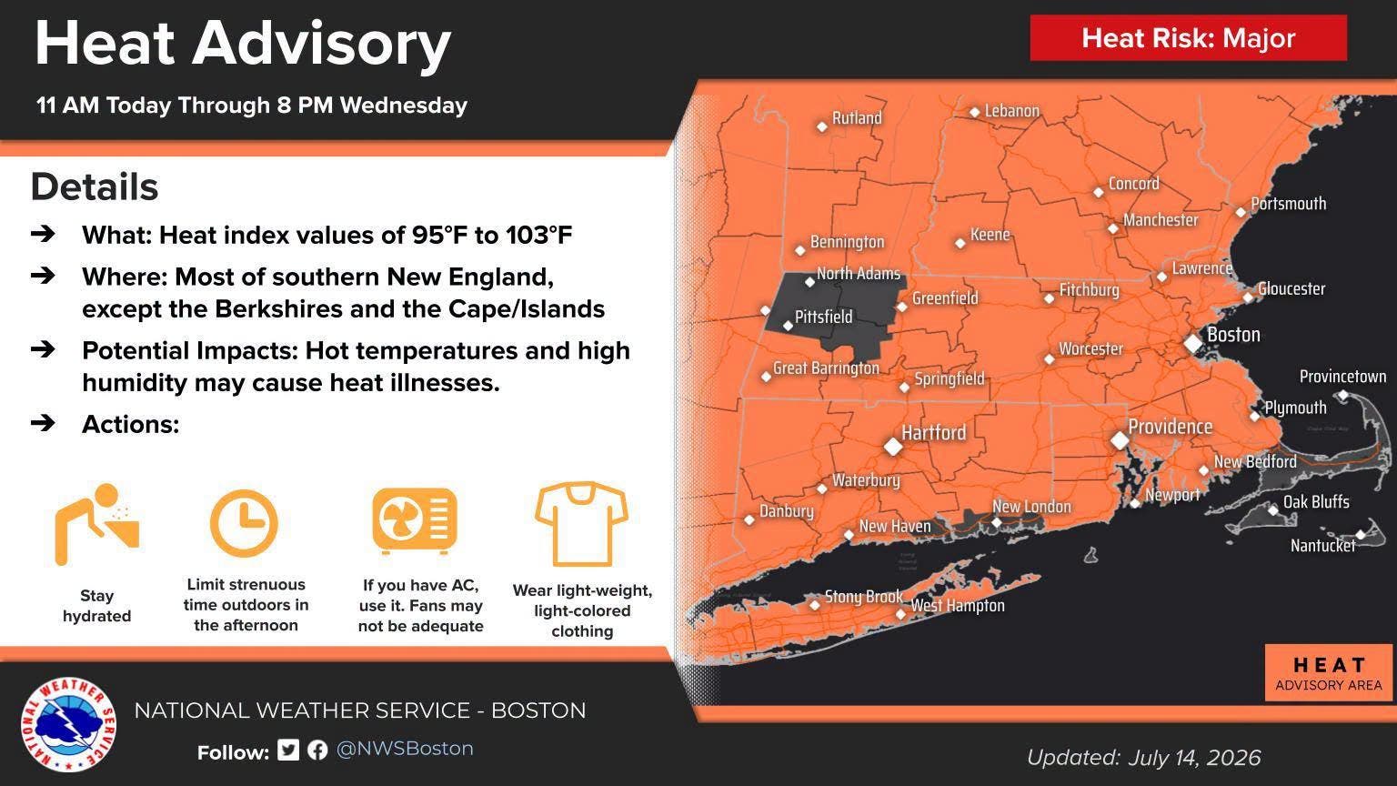
Tuesday's forecast is sunny and hot with a high temperature of 96 degrees. While dewpoints will be in the high 60s, there could be some relief in the persistent southwest breeze.
It will stay very warm Tuesday night with a low temperature of only 80 degrees and "no nighttime relief" for those without AC.
Wednesday will be another scorcher with a high temperature of 95 degrees and feels-like temperatures over 100 degrees.
Thursday will also be near 90 but with much less humidity.
The heat returns as 43 Massachusetts beaches remain closed to swimming after tests showed bacteria exeedence in the water.
The bacteria used as indicator organisms to test the waters at beaches are Enterococci and E. coli. Marine beaches are tested for the presence of Enterococci. Freshwater beaches are tested either for the presence of E. coli or Enterococci. Enteric bacteria are indicator organisms found in the intestines of warm-blooded animals and humans, often associated with fecal contamination.
An elevated presence of these organisms indicates the water may not be safe for human or animal consumption or contact, and may cause symptoms ranging from gastrointestinal pain to eye and ear discomfort to flu-like symptoms.
Most of these symptoms are minor, but occasionally a more serious illness may occur. Children, the elderly, and those with weakened immune systems are at greater risk of developing serious symptoms.
Some beach areas may remain open for recreational activities, though any contact with the water is strongly discouraged.
Massachusetts beaches closed as of 10 a.m. on Tuesday included:
- Ashby Damon Pond
- Ashland Hopkinton Reservoir
- Barnstable Eugenia Fortes
- Beverly Mingo
- Boston Tenean
- Braintree Smith Beach
- Brewster Cliff Pond at DYS
- Brewster Cliff Pond at Main
- Danvers Sandy Beach
- Dartmouth Moses Smith Creek
- Eastham Salt Pond
- Falmouth Wood Neck River
- Freetown Town Beach
- Holden Eagle Lake
- Manchester Magnolia East
- Nantucket Sesachacha
- Pembroke Little Sandy
- Provincetown 333 Commercial Street
- Provincetown Johnson Street
- Provincetown Kendall Lane
- Provincetown Snail Road
- Quincy Broady Beach
- Quincy Merrymount
- Salem Children's Island Back
- Salem Children's Island Wally
- Salem Ocean Avenue
- Salem Willow Avenue
- Saugus Peckham Pond
- Saugus Pearce Lake
- Springfield Camp Wilder
- Swampscott King's Beach
- Swansea Coles River Club
- Swansea Leeside
- Swansea Town Beach
- Templeton Beamans Pond Campground
- Templeton Beamans Pond Day
- Tisbury Vineyard Harbor Motel
- Townsend Pearl Hill Pond
- Wareham Briarwood
- Wareham Standish Shores
- Winthrop Donovan's Beach
- Winthrop Pico Beach
- Worcester Lake Quinsigamond
Latest Forecast (National Weather Service):
Tuesday
Mostly sunny and hot, with a high near 96. West wind 9 to 15 mph.
Tuesday Night
Partly cloudy, with a low around 80. West wind 8 to 11 mph, with gusts as high as 26 mph.
Wednesday
A chance of showers and thunderstorms, mainly between 10 a.m. and noon.
Partly sunny and hot, with a high near 95. West wind 8 to 11 mph, with gusts as high as 21 mph. Chance of precipitation is 30%.
Wednesday Night
Partly cloudy, with a low around 71. Northwest wind 3 to 6 mph.
Thursday
Sunny, with a high near 88. West wind 6 to 14 mph.
Thursday Night
Partly cloudy, with a low around 68. Northwest wind 5 to 9 mph.
Friday
Sunny, with a high near 83. Northwest wind 6 to 9 mph.
Friday Night
Mostly clear, with a low around 66. Northwest wind 3 to 5 mph.
Saturday
Mostly sunny, with a high near 81. Calm wind becoming southeast 5 to 8 mph in the afternoon.
Saturday Night
A chance of showers. Mostly cloudy, with a low around 67. Southwest wind 5 to 7 mph. Chance of precipitation is 40%.
Sunday
A chance of showers. Partly sunny, with a high near 82. West wind 6 to 10 mph. Chance of precipitation is 40%.
Sunday Night
A chance of showers. Mostly cloudy, with a low around 66. West wind 6 to 8 mph. Chance of precipitation is 40%.
Monday
A chance of showers. Mostly sunny, with a high near 83. Northwest wind 6 to 10 mph becoming southeast in the afternoon. Chance of precipitation is 30%.
Get more local news delivered straight to your inbox. Sign up for free Patch newsletters and alerts.