Weather
First Snow Of Season? Cold Storm May Bring Flakes To MA This Week
Snow is possible for parts of the state late this week as an ocean storm brings a winter feel to the region.


While packing those Halloween decorations away, and perhaps listening to holiday music on the radio for the first time this season, it might be a good idea to at least check to make sure you know where you put the shovels with the first hint of snow in this week's forecast.
While it does not, at this point, look like there will be anything plowable anywhere near Boston, a chilly late-week ocean storm could bring some flakes to parts of Massachusetts as temperatures take a turn for winter.
"We continue to monitor the risk for a late-week storm that would bring rain to most, though some wet snow in higher elevations can't be ruled out," the National Weather Service said on Monday.
Find out what's happening in Across Massachusettsfor free with the latest updates from Patch.
The best chance for some snow will likely come late Thursday into early Friday as temperatures hover around freezing and pockets of frigid air descend across the region.
It will be a cold rain for most, with the possibility of wind chills depending on how close the storm tracks to the coast.
Find out what's happening in Across Massachusettsfor free with the latest updates from Patch.
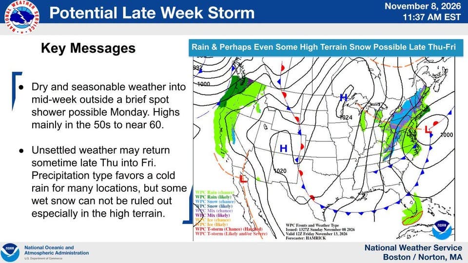
Most of the week, however, will be dry and seasonable. Though a far cry from the September-like 70s of last week, highs in the 50s are normal for mid-November and will be the forecast for Monday, Tuesday and Wednesday.
A brisk west wind will make it feel like a few degrees cooler than it is as temperatures push 60 degrees by Veterans Day.
Winds will shift around to the east on Thursday during what should be another pleasant day in the 50s.
But by Thursday night, rain moves in for most, with the possibility of snow in the higher elevations of central and western Massachusetts.
Friday is shaping up to be unpleasant either way, with rain likely, a mix of snow possible, a high of 50 degrees, and a persistent northeast wind at 21 mph.
Friday night into Saturday will be cool, with rain overnight making way for partly sunny skies and highs in the 40s.
Sunday should mark a return to a more fall-like feel with partly sunny skies and a high of 51 degrees.
See Latest Forecast (NWS):
Monday
Scattered showers, mainly between noon and 3 p.m. Mostly cloudy, with a high near 58. West wind 13 to 15 mph, with gusts as high as 26 mph. Chance of precipitation is 30%.
Monday Night
Partly cloudy, with a low around 44. West wind 10 to 15 mph.
Tuesday
Mostly sunny, with a high near 59. West wind 9 to 14 mph.
Tuesday Night
Mostly clear, with a low around 46. West wind 11 to 13 mph.
Veterans Day
Sunny, with a high near 57. Northwest wind 8 to 13 mph.
Wednesday Night
Mostly cloudy, with a low around 40. Light and variable wind becoming northeast 5 to 9 mph after midnight.
Thursday
Partly sunny, with a high near 54. Calm wind becoming east 5 to 7 mph in the afternoon.
Thursday Night
Rain likely, mainly after 1 a.m. Mostly cloudy, with a low around 43. Northeast wind 8 to 18 mph. Chance of precipitation is 70%.
Friday
Rain likely. Mostly cloudy, with a high near 51. Breezy, with a northeast wind around 21 mph. Chance of precipitation is 70%.
Friday Night
Rain likely, mainly before 3 a.m. Mostly cloudy, with a low around 39. North wind 14 to 16 mph. Chance of precipitation is 60%.
Saturday
A chance of rain. Partly sunny, with a high near 49. North wind around 16 mph, with gusts as high as 26 mph. Chance of precipitation is 50%.
Saturday Night
A chance of rain. Mostly cloudy, with a low around 36. Northwest wind 11 to 13 mph. Chance of precipitation is 30%.
Sunday
Partly sunny, with a high near 51. Northwest wind 13 to 15 mph.
Get more local news delivered straight to your inbox. Sign up for free Patch newsletters and alerts.