Weather
'Polar Plunge' Brings First Snow, Cold Rain To MA: See Latest Timeline
Elevated areas of Massachusetts could see some accumulating snow Thursday into Saturday.


The first flakes of the season will be flying across parts of Massachusetts in the coming days as a cold, winter-like storm brings a chilly rain to most and some minor accumulations to the higher elevations of central New England as part of a "polar plunge."
The National Weather Service is forecasting snow to mix in with rain as cold air settles into the region overnight Thursday into Friday.
The NWS said any accumulations should be light and that there is a low probability of winter weather travel impacts.
Find out what's happening in Across Massachusettsfor free with the latest updates from Patch.
"An anomalous polar plunge will bring the coldest air of the season so far to much of the central and eastern U.S. beginning Wednesday night," the NWS said on Wednesday. "A steady rain is expected to develop from northern Mid-Atlantic to southern New England on Thursday, which will likely linger into Friday as the expansive cyclone begins to move off the East Coast. This will bring increasing winds near the coast and the risk for minor coastal flooding at high tides.
"As colder air wraps in behind the system, rain is forecast to snow over the higher elevations of the central and southern Appalachians Thursday night, and wet snow is possible in the higher terrain of the interior Northeast."
Find out what's happening in Across Massachusettsfor free with the latest updates from Patch.
Wednesday will be a pleasant day with partly sunny skies and high temperatures approaching 60 degrees.
Rain will arrive Thursday afternoon with temperatures holding in the low 50s as chilly winds switch around from the northeast.
Steady rain and much colder temperatures are forecast for Thursday night into Friday. Friday's high temperature is 42 degrees, with a north wind up to 20 mph making it feel even more uncomfortable.
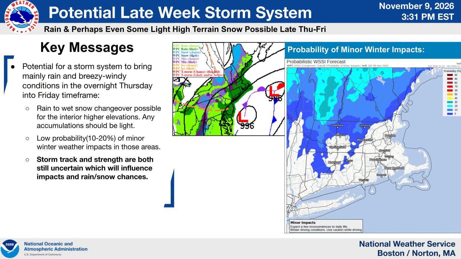
Some snow will mix in along the higher elevations of Worcester County and the Berkshires.
The rain and wet snow mix will linger into Saturday with improving conditions in the afternoon.
Highs this weekend will be in the 40s both days before a warming trend comes back next week.
See Latest Forecast:
Veterans Day
Increasing clouds, with a high near 58. West wind 8 to 14 mph.
Tonight
Cloudy, with a low around 41. Northwest wind 3 to 6 mph.
Thursday
Rain likely, mainly after 2pm. Cloudy, with a high near 52. Northeast wind 6 to 11 mph increasing to 12 to 17 mph in the afternoon. Chance of precipitation is 70%. New precipitation amounts of less than a tenth of an inch possible.
Thursday Night
Rain. Low around 40. Breezy, with a northeast wind 15 to 20 mph. Chance of precipitation is 100%. New precipitation amounts between a quarter and half of an inch possible.
Friday
Rain, mainly before 1 p.m. High near 42. North wind 11 to 17 mph. Chance of precipitation is 80%.
Friday Night
A chance of showers, mainly before 9 p.m. Mostly cloudy, with a low around 36. Northwest wind 8 to 11 mph. Chance of precipitation is 30%.
Saturday
A chance of rain before 1 p.m. Mostly cloudy, with a high near 47. Northwest wind 9 to 11 mph. Chance of precipitation is 30%.
Saturday Night
Mostly cloudy, with a low around 37. Northwest wind around 9 mph.
Sunday
Mostly sunny, with a high near 49. Northwest wind 9 to 13 mph.
Sunday Night
Partly cloudy, with a low around 36. Northwest wind 6 to 8 mph.
Monday
Sunny, with a high near 50. Northwest wind around 7 mph.
Monday Night
Mostly clear, with a low around 33. Northwest wind around 5 mph.
Tuesday
Sunny, with a high near 51. Northwest wind around 5 mph becoming calm in the afternoon.
See Also: El Niño 'Supersized Before Our Eyes': What This Means For Winter In MA
Get more local news delivered straight to your inbox. Sign up for free Patch newsletters and alerts.