Weather
Extreme Cold Watch Issued As Wind Chills Near 45 Below In Minnesota
Light snow and blowing snow Wednesday will be followed by dangerous wind chills across Minnesota late this week.

MINNEAPOLIS–ST. PAUL, MN — A dangerous stretch of winter weather is taking shape across Minnesota and western Wisconsin, with light snow and blowing snow on Wednesday, giving way to life-threatening cold later this week.
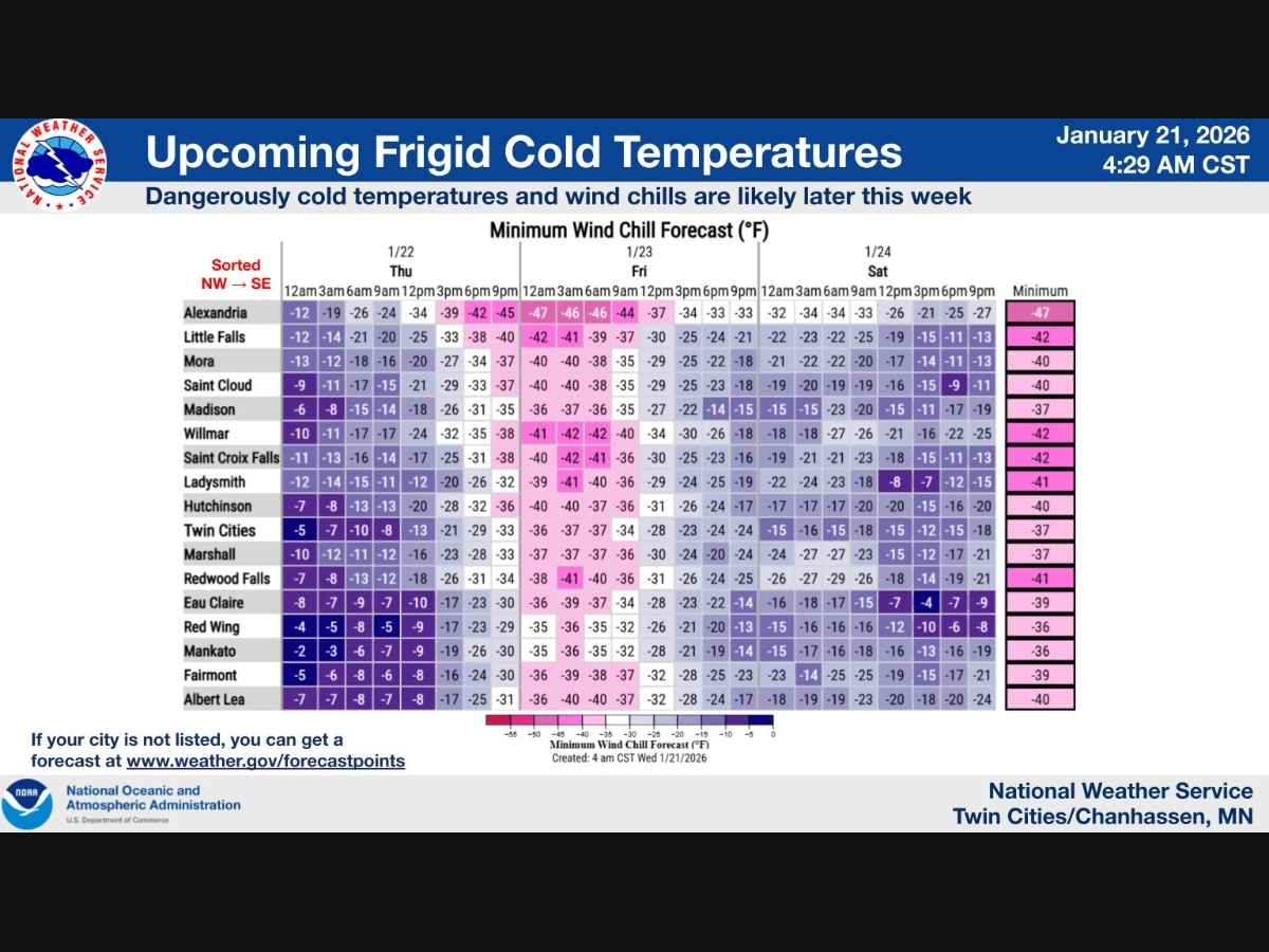
The National Weather Service has issued an Extreme Cold Watch from Thursday evening through Saturday morning for much of Minnesota, including the Twin Cities metro, warning that wind chills could plunge as low as 45 below zero in some areas.
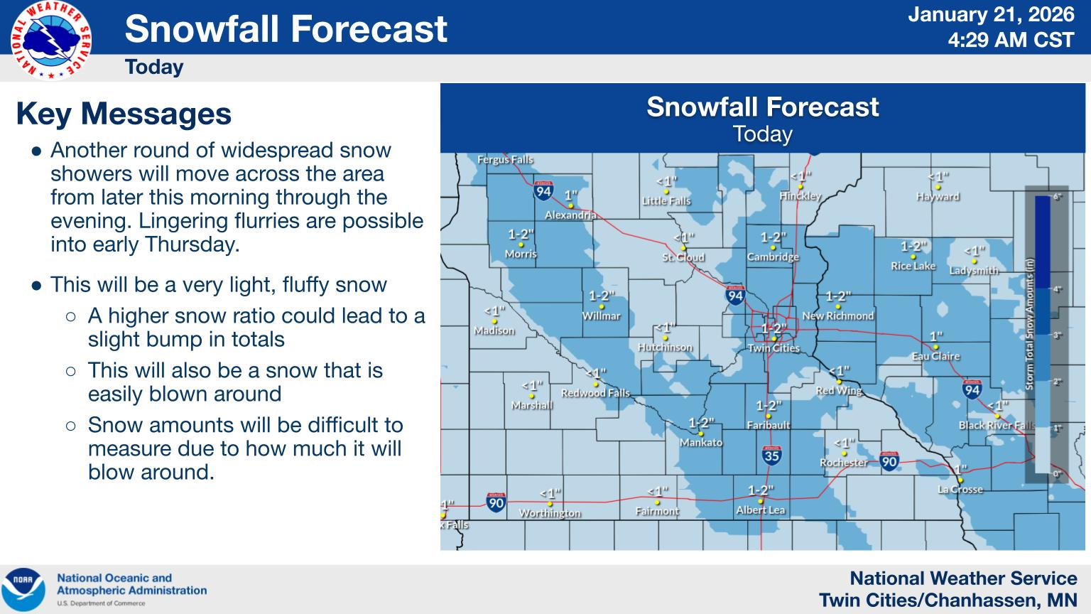
Before the Arctic air arrives, residents will contend with a round of light but widespread snow on Wednesday.
Find out what's happening in Minneapolisfor free with the latest updates from Patch.
Accumulations are expected to average around an inch, with some areas picking up 1 to 2 inches. While totals are modest, strong winds gusting to 35–45 mph will create areas of blowing snow and reduced visibility, prompting a Winter Weather Advisory in parts of the region.
The most dangerous conditions arrive Thursday night as temperatures fall sharply and winds remain brisk.
Find out what's happening in Minneapolisfor free with the latest updates from Patch.
Overnight lows are expected to drop near or below 20 degrees below zero, with wind chills as low as 40 below across central Minnesota and around 35 below in the Twin Cities. Bitter cold is expected to persist through Friday and into early Saturday.
According to the National Weather Service, frostbite can occur on exposed skin in as little as 10 minutes at those wind chill levels.
Officials urge residents to limit time outdoors, dress in multiple layers, and cover exposed skin if travel is necessary. Pet owners are advised to keep animals indoors, and neighbors are encouraged to check on older adults and anyone without reliable heat. Portable heaters should be used carefully, and grills or generators should never be operated indoors.
While temperatures are expected to slowly moderate by Sunday, forecasters stress that the late-week cold outbreak is not routine January weather and poses a serious risk to anyone unprepared.
Here's the full NWS forecast from the Minneapolis-St. Paul Airport:
Today: Snow with a chance of flurries before 2pm, then snow likely, mainly between 2pm and 4pm. Patchy blowing snow after 4pm. High near 23. Blustery, with a southwest wind 10 to 15 mph increasing to 15 to 20 mph in the afternoon. Winds could gust as high as 35 mph. Chance of precipitation is 80%. Total daytime snow accumulation of 1 to 2 inches possible.
Tonight: Patchy blowing snow before 7pm. Partly cloudy, with a low around 4. Blustery, with a west northwest wind 15 to 20 mph decreasing to 10 to 15 mph after midnight. Winds could gust as high as 35 mph.
Thursday: Mostly sunny, with a temperature rising to near 8 by 10am, then falling to around -2 during the remainder of the day. Wind chill values as low as -24. Blustery, with a west northwest wind 10 to 20 mph, with gusts as high as 30 mph.
Thursday Night: Mostly clear, with a low around -19. Wind chill values as low as -40. Northwest wind 10 to 15 mph.
Friday: Sunny and cold, with a high near -8. Northwest wind around 10 mph.
Friday Night: Partly cloudy, with a low around -19. West northwest wind 5 to 10 mph becoming light west after midnight.
Saturday: Mostly sunny and cold, with a high near -2. Calm wind becoming south southwest around 5 mph in the morning.
Saturday Night: Mostly cloudy, with a low around -12. South southeast wind around 5 mph.
Sunday: Mostly sunny and cold, with a high near 3. South southeast wind 5 to 10 mph becoming west in the morning.
Sunday Night: Partly cloudy, with a low around -9. West southwest wind 5 to 10 mph.
Monday: Mostly sunny, with a high near 13. Southwest wind around 10 mph.
Monday Night: Partly cloudy, with a low around 3. West southwest wind 5 to 10 mph.
Tuesday: Partly sunny, with a high near 19. West wind 5 to 10 mph.
Get more local news delivered straight to your inbox. Sign up for free Patch newsletters and alerts.


