Weather
Winter Weather Advisories Issued As Storm Targets MN: See Latest Snowfall Estimates
A winter weather advisory is in place until 9 p.m. Wednesday for much of central Minnesota, including Minneapolis and St. Paul.

Winter is making a comeback on Wednesday as a storm system pushes across Minnesota, snarling travel and potentially dropping up to 4 inches of snow on the Twin Cities, according to the latest forecasts.
A winter weather advisory is in place until 9 p.m. Wednesday for much of central Minnesota, including Minneapolis and St. Paul, as a band of moderate to heavy snow moves west across the state, according to the National Weather Service.
In its latest forecast, the National Weather Service said between 2 and 4 inches of snow could fall in the metro, with up to an inch per hour possible and wind gusts reaching 45 mph.
Find out what's happening in Minneapolisfor free with the latest updates from Patch.
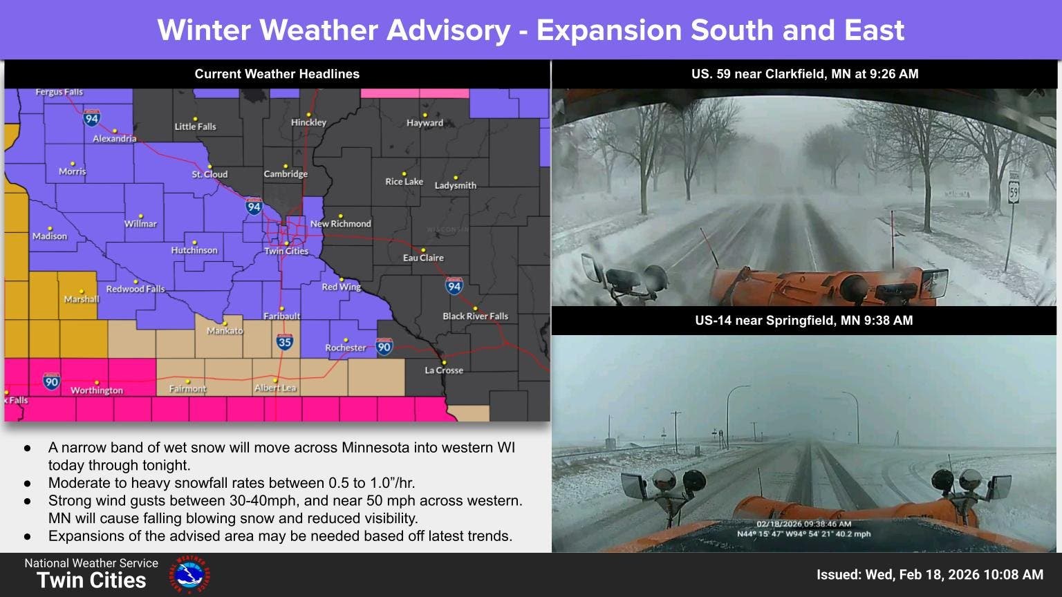
"Falling snow and gusty winds will combine to reduce visibility and slick travel this afternoon," NWS forecasters said on Wednesday. "The hazardous conditions will impact the Wednesday evening commute, and gusty winds could bring down tree branches."
For those traveling, areas of northern Minnesota are under winter storm or blizzard warnings. Yellow Medicine, Redwood, and Brown Counties in southwest Minnesota are also under a blizzard warning.
Find out what's happening in Minneapolisfor free with the latest updates from Patch.
"We have received reports of whiteout conditions via law enforcement, and with snow expected to continue through the afternoon and early evening, we anticipate these conditions to continue or worsen at times," NWS forecasters wrote.
While snow will likely move out of the metro on Wednesday night, gusty winds will linger before another chance of snow returns Thursday night into Friday. The highest chances for snow will be mainly across southeast Minnesota and west-central Wisconsin.
Later this week, forecasters said temperatures will return to more seasonal levels ahead of a quiet weekend.
Here's the latest detailed forecast for the Twin Cities:
Wednesday: Snow. Patchy blowing snow after 5pm. Steady temperature around 33. Southwest wind around 15 mph, with gusts as high as 30 mph. Chance of precipitation is 90%. Total daytime snow accumulation of 2 to 4 inches possible.
Wednesday Night: Snow, mainly before midnight. Low around 30. West wind 5 to 15 mph, with gusts as high as 30 mph. Chance of precipitation is 80%. New snow accumulation of 1 to 3 inches possible.
Thursday: Cloudy, with a high near 38. North wind 5 to 10 mph.
Thursday Night: A chance of rain and snow before 10pm, then a chance of snow. Mostly cloudy, with a low around 24. Northwest wind 10 to 15 mph. Chance of precipitation is 40%.
Friday: A 30 percent chance of snow, mainly before noon. Mostly cloudy, with a high near 29. West northwest wind around 15 mph.
Friday Night: Mostly cloudy, with a low around 16. West northwest wind 10 to 15 mph.
Saturday: Partly sunny, with a high near 25. Northwest wind 10 to 15 mph.
Saturday Night: Partly cloudy, with a low around 12. Northwest wind 10 to 15 mph.
Sunday: Mostly sunny, with a high near 23. Northwest wind 10 to 15 mph.
Get more local news delivered straight to your inbox. Sign up for free Patch newsletters and alerts.


