Weather
‘Life Threatening’ Weather Moves Into NJ Monday, Forecasters Say
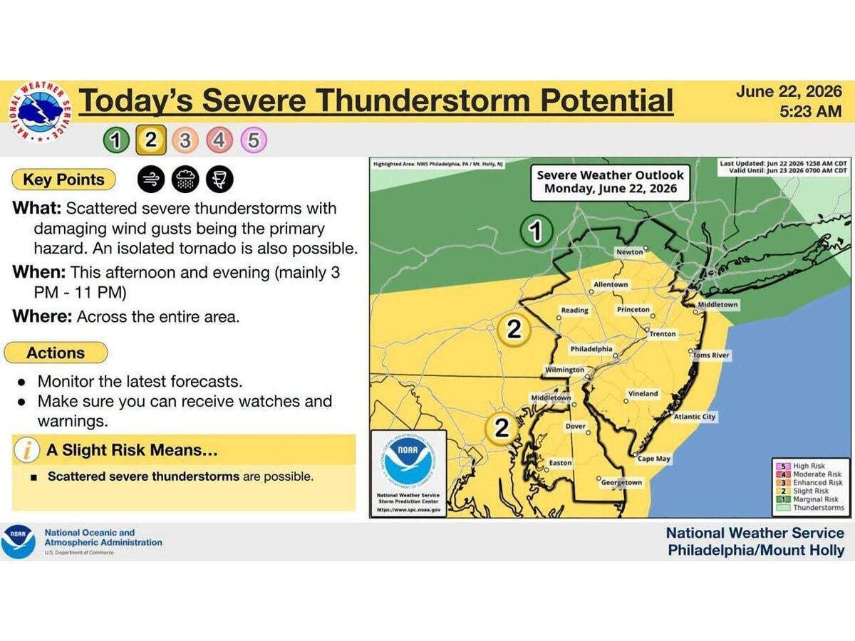
Severe thunderstorms with "damaging wind gusts" have triggered flood watches throughout the state.

A flood watch has been issued across multiple New Jersey counties as severe thunderstorms approach the Garden State.
According to the latest forecast from the National Weather Service (NWS), scattered, severe thunderstorms are expected alongside some flash flooding late Monday afternoon and evening.
Though the day will begin on the quieter end, NWS is predicting that thunderstorms will come with "damaging wind gusts" and the potential for an isolated tornado.
Find out what's happening in Across New Jerseyfor free with the latest updates from Patch.
Timing for this weather is expected to stretch from 3 p.m. to 11 p.m. on Monday.
In addition to scattered thunderstorms, forecasters said there is also a high risk for the development of "dangerous and life-threatening rip currents" on Monday for Jersey Shore beaches in Ocean, Atlantic and Cape May Counties.
Find out what's happening in Across New Jerseyfor free with the latest updates from Patch.
NWS is advising residents to monitor the latest forecasts and make sure you can receive watches and warnings.
On Monday morning, NWS issued a Flood Watch across multiple New Jersey counties from 2 p.m. through late Monday night.
The watch was issued in:
- Camden County
- Gloucester County
- Hunterdon County
- Mercer County
- Middlesex County
- Morris County
- Northwestern Burlington County
- Salem County
- Somerset County
- Western Monmouth County
The greatest risk for flash flooding is in urban and poor drainage areas, according to NWS.
Rainfall rates of two inches per hour are possible, forecasters said.
The latest forecast from the weather service is as follows:
North Jersey
- Monday: A chance of showers, then showers and possibly a thunderstorm after 2 p.m. Some of the storms could produce heavy rainfall. High near 78. Southeast wind 5-10 MPH. Chance of precipitation is 80%. New rainfall amounts between a half and three-quarters of an inch possible.
- Monday Night: Showers and possibly a thunderstorm. Some of the storms could produce heavy rainfall. Low around 66. South wind 5-8 MPH. Chance of precipitation is 80%. New rainfall amounts between a half and three-quarters of an inch possible.
- Tuesday: Showers likely, mainly before 8 a.m. Mostly cloudy, with a high near 79. North wind 6-9 MPH. Chance of precipitation is 60%. New precipitation amounts between a tenth and a quarter of an inch possible.
- Tuesday Night: Mostly cloudy during the early evening, then gradual clearing, with a low around 63. Northwest wind around 8 MPH.
- Wednesday: Sunny, with a high near 84. Northwest wind around 7 MPH.
- Wednesday Night: Mostly clear, with a low around 65.
- Thursday: A 30 percent chance of showers after 2 p.m. Mostly sunny, with a high near 85.
- Thursday Night: A chance of showers and thunderstorms before 8 p.m., then showers likely and possibly a thunderstorm between 8 p.m. and 2 a.m., then showers likely after 2 a.m. Mostly cloudy, with a low around 67. Chance of precipitation is 60%.
- Friday: A chance of showers, with thunderstorms also possible after 2 p.m. Mostly cloudy, with a high near 85. Chance of precipitation is 50%.
- Friday Night: A chance of showers and thunderstorms before 8 p.m., then a chance of showers between 8 p.m. and 2 a.m. Mostly cloudy, with a low around 68. Chance of precipitation is 30%.
- Saturday: Mostly sunny, with a high near 83.
- Saturday Night: Partly cloudy, with a low around 68.
- Sunday: Mostly sunny, with a high near 86.
Central Jersey
- Monday: A chance of showers and thunderstorms between 11 a.m. and 3 p.m., then showers likely and possibly a thunderstorm after 3 p.m. Some of the storms could be severe and produce heavy rainfall. Cloudy, with a high near 80. Southeast wind 10-15 MPH, with gusts as high as 25 MPH. Chance of precipitation is 70%. New rainfall amounts between a quarter and half of an inch are possible.
- Monday Night: Showers and possibly a thunderstorm, mainly before 4 a.m., then a chance of showers and thunderstorms after 4 a.m. Some of the storms could be severe and produce heavy rainfall. Low around 66. South wind 5-15 MPH, with gusts as high as 30 MPH. Chance of precipitation is 90%. New rainfall amounts between a quarter and half of an inch are possible.
- Tuesday: Showers, with thunderstorms also possible after 3 p.m. High near 78. North wind 10-15 MPH. Chance of precipitation is 80%. New rainfall amounts between a quarter and half of an inch are possible.
- Tuesday Night: Mostly cloudy, then gradually becoming clear, with a low around 62. Northwest wind around 10 MPH.
- Wednesday: Sunny, with a high near 83. Northwest wind 5-10 MPH.
- Wednesday Night: Mostly clear, with a low around 64.
- Thursday: Mostly sunny, with a high near 85.
- Thursday Night: A chance of showers and thunderstorms. Mostly cloudy, with a low around 66. Chance of precipitation is 50%.
- Friday: A chance of showers, then showers likely and possibly a thunderstorm after 2 p.m. Mostly cloudy, with a high near 87. Chance of precipitation is 60%.
- Friday Night: Showers likely and possibly a thunderstorm before 8 p.m., then a chance of showers and thunderstorms between 8 p.m. and 2 a.m. Mostly cloudy, with a low around 67. Chance of precipitation is 60%.
- Saturday: Mostly sunny, with a high near 83.
- Saturday Night: Partly cloudy, with a low around 66.
- Sunday: Mostly sunny, with a high near 85.
South Jersey
- Monday: Partly sunny, with a high near 78. Breezy, with a south wind 15-20 MPH increasing to 20-25 MPH in the afternoon.
- Monday Night: Showers and thunderstorms before 1 a.m., then showers likely and possibly a thunderstorm between 1 a.m. and 3 a.m., then a chance of showers and thunderstorms after 3 a.m. Some of the storms could be severe and produce heavy rainfall. Low around 68. Breezy, with a south wind 10-20 MPH. Chance of precipitation is 80%. New rainfall amounts between a quarter and half of an inch are possible.
- Tuesday: Showers likely, with thunderstorms also possible after 2 p.m. Partly sunny, with a high near 79. Southwest wind 5-15 MPH becoming north in the afternoon. Chance of precipitation is 60%. New rainfall amounts between a quarter and half of an inch are possible.
- Tuesday Night: Mostly cloudy, then gradually becoming clear, with a low around 67. Northwest wind 10-15 MPH.
- Wednesday: Sunny, with a high near 80. Northwest wind 5-15 MPH.
- Wednesday Night: Mostly clear, with a low around 67.
- Thursday: Sunny, with a high near 81.
- Thursday Night: A chance of showers, with thunderstorms also possible after 2 a.m. Mostly cloudy, with a low around 72. Chance of precipitation is 40%.
- Friday: A chance of showers and thunderstorms before 8 a.m., then a chance of showers between 8 a.m. and 2 p.m., then a chance of showers and thunderstorms after 2 p.m. Partly sunny, with a high near 86. Chance of precipitation is 40%.
- Friday Night: A chance of showers and thunderstorms. Mostly cloudy, with a low around 73. Chance of precipitation is 30%.
- Saturday: A chance of showers. Partly sunny, with a high near 86. Chance of precipitation is 30%.
- Saturday Night: A chance of showers. Partly cloudy, with a low around 73. Chance of precipitation is 30%.
- Sunday: Mostly sunny, with a high near 86.
Get more local news delivered straight to your inbox. Sign up for free Patch newsletters and alerts.