Weather
Severe Thunderstorm Watch Issued Across NJ: See Timing
Storms could bring scattered hail "up to ping pong size" on Thursday afternoon and evening, forecasters said.


A Severe Thunderstorm Watch has been issued across New Jersey as storms move in that could bring hail and scattered wind gusts up to 70 MPH.
According to the latest forecast from the National Weather Service (NWS), the Thunderstorm Watch will be in effect until 8 p.m. on Thursday across all New Jersey counties.
Scattered hail up to "ping pong size" is possible, as well as "a couple tornadoes," NWS said.
Find out what's happening in Across New Jerseyfor free with the latest updates from Patch.
The Severe Thunderstorm Watch comes after a Flood Watch was issued on Thursday morning in Camden, Gloucester, Hunterdon, Mercer, Middlesex, Morris, Northwestern Burlington, Somerset, Sussex and Western Monmouth Counties that's expected to last through Thursday night.
Scattered thunderstorms are expected to produce areas of heavy rainfall that could lead to flash flooding, with the Flood Watch expanded to include more of South Jersey on Thursday morning.
Find out what's happening in Across New Jerseyfor free with the latest updates from Patch.
"The primary threat for Thursday afternoon and evening remains damaging wind gusts," the NWS said. "Be sure to have multiple ways to receive warnings and stay weather aware!"
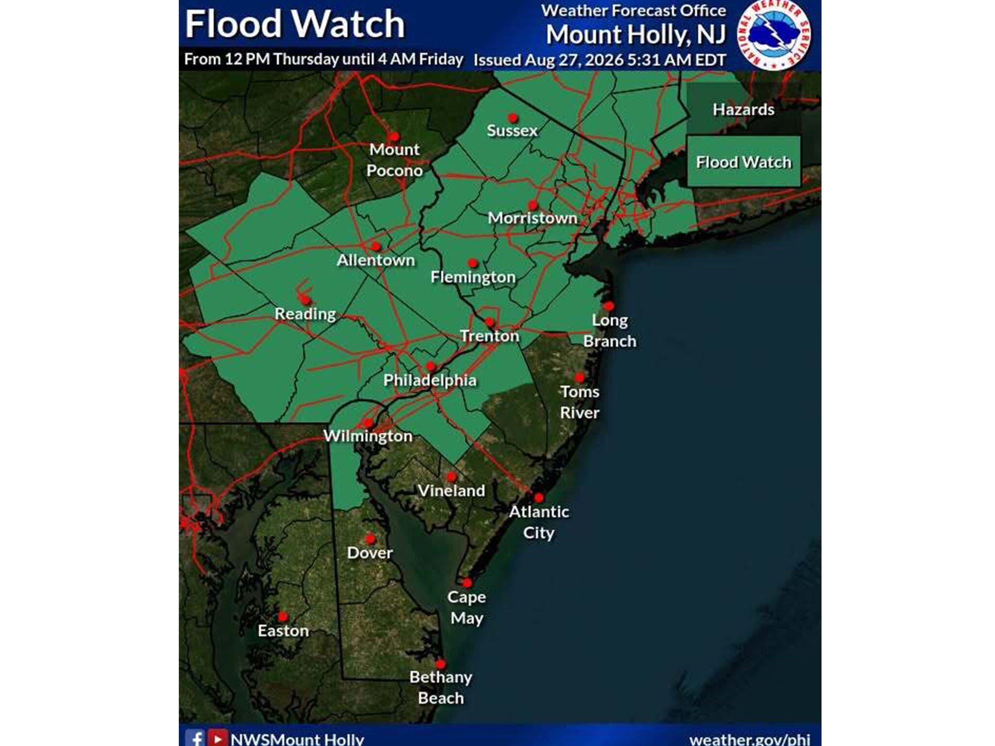
As thunderstorms approach the Garden State, forecasters said rainfall rates of 1-3" per hour could lead to flash flooding, mainly along the I-95 corridor and points north and west.
The weather service recommends residents monitor the latest forecast and make sure they can receive watches and warnings as storms move in.
Here's the latest forecast from the National Weather Service:
NORTH JERSEY
- Thursday: A chance of showers and thunderstorms, then showers and possibly a thunderstorm after 2 p.m. High near 83. South wind 6-10 MPH, with gusts as high as 20 MPH. Chance of precipitation is 80%. New rainfall amounts between a quarter and half of an inch possible.
- Thursday Night: Showers likely and possibly a thunderstorm before 8 p.m., then a chance of showers and thunderstorms between 8 p.m. and 2 a.m., then a slight chance of showers after 2 a.m. Mostly cloudy, with a low around 69. South wind around 5 MPH, becoming calm in the evening. Chance of precipitation is 60%. New rainfall amounts between a quarter and half of an inch are possible.
CENTRAL JERSEY
- Thursday: A chance of showers and thunderstorms, mainly between 10 a.m. and 5 p.m. Mostly cloudy, with a high near 84. South wind 5-10 MPH. Chance of precipitation is 50%. New rainfall amounts between a tenth and a quarter of an inch, except higher amounts possible in thunderstorms.
- Thursday Night: A chance of showers and thunderstorms before 2 a.m., then a slight chance of showers after 3 a.m. Patchy fog after 4 a.m. Otherwise, increasing clouds, with a low around 68. South wind around 5 MPH becoming calm in the evening. Chance of precipitation is 30%. New rainfall amounts of less than a tenth of an inch, except higher amounts possible in thunderstorms.
SOUTH JERSEY
- Thursday: A slight chance of showers and thunderstorms between noon and 3 p.m. Mostly sunny, with a high near 84. South wind 10-15 MPH. Chance of precipitation is 20%.
- Thursday Night: A slight chance of showers and thunderstorms before 11 p.m., then a slight chance of showers and thunderstorms after 2 a.m. Mostly cloudy, with a low around 71. South wind 5-10 MPH. Chance of precipitation is 20%.
Editor's Note: This article has been updated with new information from the National Weather Service.
Get more local news delivered straight to your inbox. Sign up for free Patch newsletters and alerts.