Weather
Full Moon-Fueled Nor’easter On Collision Course With NJ
Forecasters warn coastal flooding could worsen with each high tide as a weekend storm takes shape.


NEW JERSEY— A developing coastal storm could bring stronger winds and heavier rain to New Jersey through the weekend, while tidal flooding continues along coastal and bayside communities.
Forecasters expect repeated rounds of flooding in vulnerable coastal and bayside communities, with some roads potentially becoming impassable, according to the National Weather Service in Mount Holly.
"There is still a large amount of uncertainty with the storm track into the weekend," the National Weather Service wrote.
Find out what's happening in Across New Jerseyfor free with the latest updates from Patch.
The National Weather Service has a Coastal Flood Advisory or Warning in effect for affected areas through Friday night, depending on location.
Multiple rounds of minor to moderate tidal flooding could affect the Atlantic coast, Delaware Bay, southern Raritan Bay, the tidal Delaware River and Chesapeake Bay.
Find out what's happening in Across New Jerseyfor free with the latest updates from Patch.
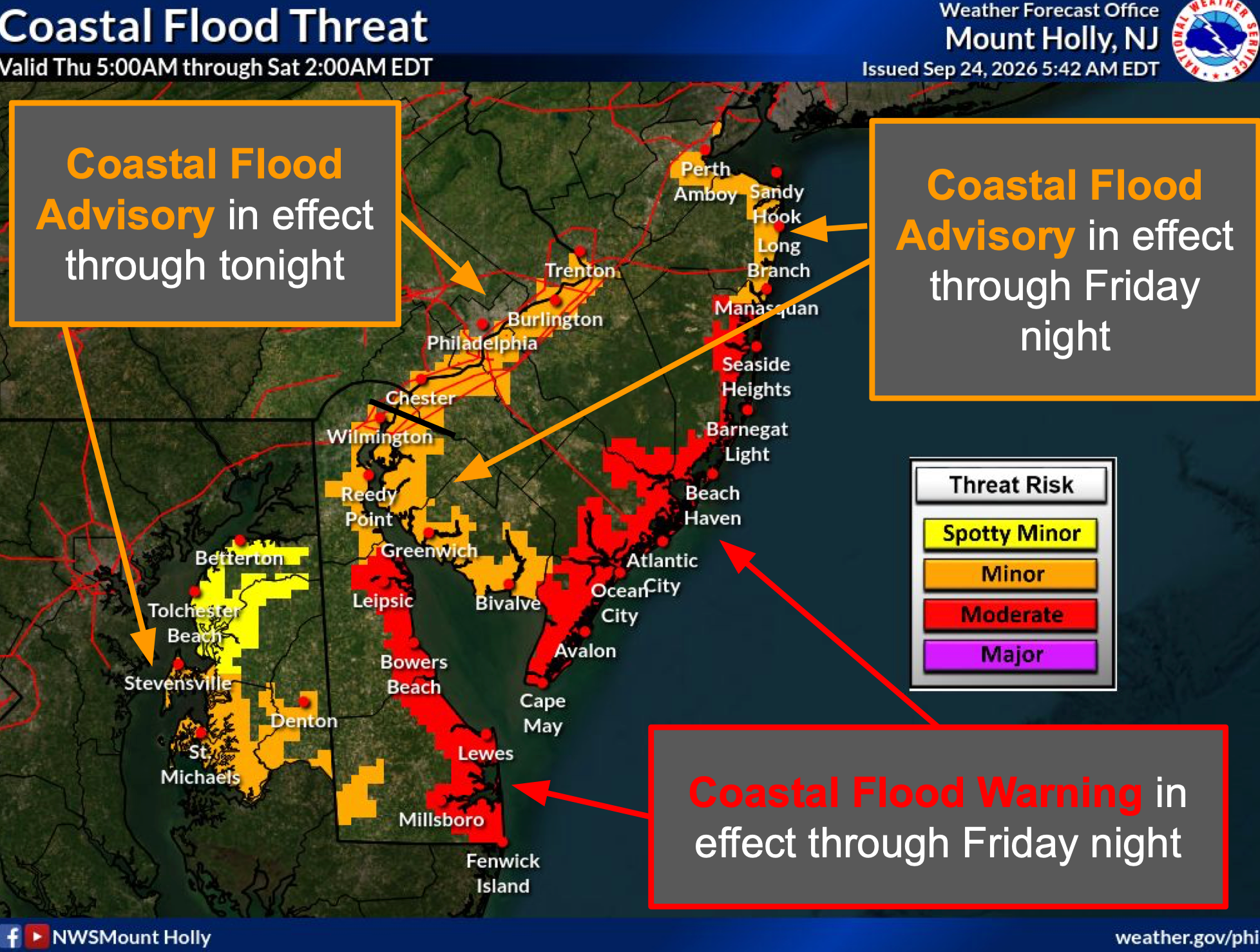
Back-bay communities, including areas around Barnegat Bay and the Shrewsbury River, could see some of the most persistent flooding.
Complicating matters is the full moon, which is expected to amplify high tides along the East Coast.
The rare September nor’easter and the full moon will collide shortly before 1 p.m. Saturday with the elevated gravitational tides merging with the storm surge, bringing dangerous flood risk to the Garden State.
The forecast becomes less certain Friday night and into the weekend as a storm develops and moves northward offshore.
A storm track closer to the New Jersey coast could bring significant coastal flooding, high surf and stronger winds into Saturday.
A track farther offshore would reduce the inland rain and wind threat, but could still leave coastal communities dealing with flooding, rough surf and strong winds.
Residents should avoid driving through flooded roads and avoid parking in areas prone to flooding, the weather service warned.
How Strong Will The Winds Get?
Northeast winds will remain strong along the Atlantic coast through Friday, with sustained winds around 25 to 35 mph and gusts up to 50 mph possible.
A Wind Advisory remains in effect for Atlantic coastal New Jersey through 6 p.m. Friday.
A High Wind Watch covers Friday night through Saturday.
Coastal waters face even stronger conditions, with gale-force winds and seas of 8 to 15 feet. Storm-force gusts could develop Friday into Saturday.
Thursday will remain cloudy and breezy, with a high near 66 degrees and northeast wind gusts up to 30 mph.
Friday will reach about 68 degrees, with a 30 percent chance of showers after 2 p.m. Winds could gust to 30 mph.
Saturday will stay cool, near 67 degrees, with a 50 percent chance of showers and wind gusts up to 30 mph.
Rain chances increase Saturday night, when showers could become likely and a thunderstorm could develop.
The forecast calls for drier weather and warmer temperatures early next week, with highs near 69 degrees Monday, 73 Tuesday and 76 Wednesday.
Central New Jersey
- Flooding: Coastal and bayside flooding could affect communities around southern Raritan Bay and the Shrewsbury River during high tides.
- Winds: Northeast winds will remain strong along the coast, with gusts potentially reaching 50 mph.
- Weekend: Conditions depend on the storm's track. A closer track could bring heavier rain and stronger winds.
- Beach: Dangerous surf, rip currents and beach erosion remain concerns through Saturday.
North Jersey
- Flooding: Southern Raritan Bay and the tidal Delaware River could see repeated rounds of tidal flooding through Friday night and potentially into the weekend.
- Winds: Coastal areas will remain breezy, while inland areas could see gusts around 35 mph.
- Weekend: A storm track farther offshore would limit the strongest rain and winds inland, but coastal flooding and rough marine conditions could persist.
- Temperatures: Highs will stay in the mid-60s through Sunday before warming next week.
South Jersey
- Flooding: Coastal communities, back bays and areas around Barnegat Bay face repeated tidal flooding during high tides.
- Winds: Atlantic coastal areas could see sustained northeast winds of 25 to 35 mph, with gusts up to 50 mph through Friday.
- Surf: High rip-current risk, dangerous surf, significant beach erosion and possible dune breaches could affect the shore through Saturday.
- Weekend: A storm passing close to the coast could bring heavier rain and stronger winds Friday night through Sunday. An eastward track would leave mainly coastal flooding, high seas and gusty coastal winds.
Get more local news delivered straight to your inbox. Sign up for free Patch newsletters and alerts.