Weather
Thunderstorm Threat Increases In NJ Midweek: Latest Forecast
Following severe thunderstorms that blanketed parts of New Jersey over the weekend, more rain is expected throughout the week.

Following severe thunderstorms that blanketed parts of New Jersey over the weekend, Garden State residents should brace for another round of scattered storms and wind forecast throughout the week.
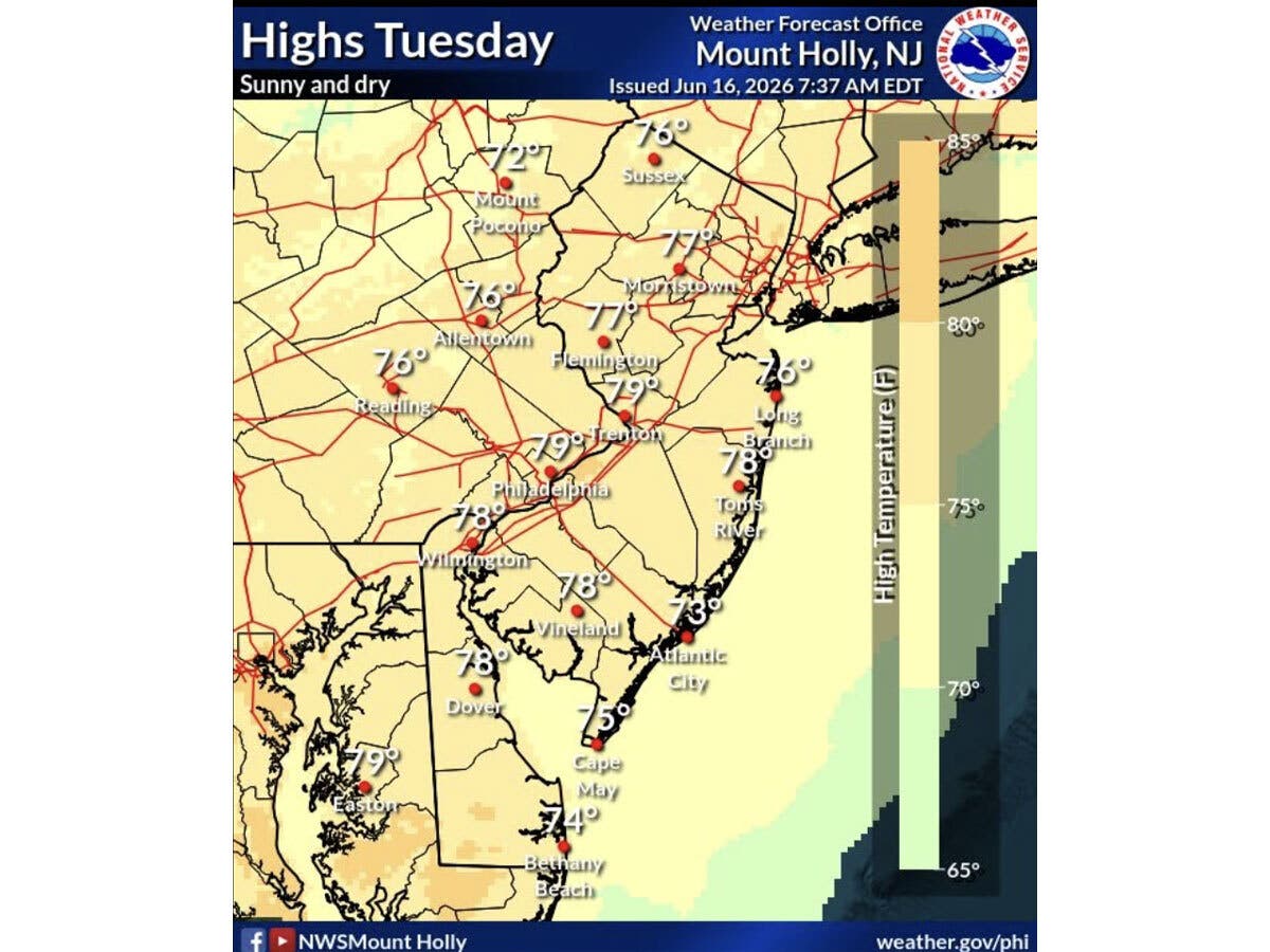
While New Jerseyans will experience sunny skies and temperatures in the high 70s to low 80s on Tuesday, the National Weather Service (NWS) is predicting potential scattered showers and storms overnight and into Wednesday.
Though residents may experience some rain, forecasters said no severe storms are expected.
Find out what's happening in Across New Jerseyfor free with the latest updates from Patch.
Rain on Wednesday will be followed by a hotter and very breezy (wind gusts 30-40 MPH) Thursday, with a risk of scattered severe storms, the NWS said.
This will be followed by temperatures in the low 80s on Friday, with a chance of showers in South Jersey.
Find out what's happening in Across New Jerseyfor free with the latest updates from Patch.
On Saturday, sunny skies are expected to return to the Garden State with temperatures in the mid-80s and remain throughout Sunday.
Here’s the latest forecast for New Jersey from the National Weather Service:
North Jersey
- Tuesday: Sunny, with a high near 79. West wind around 6 MPH.
- Tuesday Night: Partly cloudy, with a low around 63. South wind 5-8 MPH becoming calm after midnight.
- Wednesday: A chance of showers, with thunderstorms also possible after 2 p.m. Partly sunny, with a high near 78. Light southeast wind becoming south 5-10 MPH in the morning. Chance of precipitation is 40%.
- Wednesday Night: Mostly cloudy, with a low around 65. Southeast wind 3-7 MPH.
- Thursday: A chance of showers, with thunderstorms also possible after 2 p.m. Mostly cloudy, with a high near 88. South wind 8-17 MPH, with gusts as high as 29 MPH. Chance of precipitation is 50%.
- Thursday Night: Partly cloudy, with a low around 69.
- Friday: Mostly sunny, with a high near 82.
- Friday Night: Partly cloudy, with a low around 65.
- Saturday: Sunny, with a high near 83.
- Saturday Night: Mostly clear, with a low around 64.
- Sunday: Sunny, with a high near 85.
- Sunday Night: Partly cloudy, with a low around 66.
Central Jersey
- Tuesday: Sunny, with a high near 78. Southwest wind around 5 MPH.
- Tuesday Night: Increasing clouds, with a low around 60. South wind around 5 MPH.
- Wednesday: A slight chance of showers before 11 a.m., then a chance of showers and thunderstorms after 2 p.m. Partly sunny, with a high near 78. South wind 5-10 MPH. Chance of precipitation is 40%. New rainfall amounts of less than a tenth of an inch, except higher amounts possible in thunderstorms.
- Wednesday Night: A chance of showers and thunderstorms, mainly before 7 p.m. Mostly cloudy, with a low around 65. South wind around 5 MPH. Chance of precipitation is 30%. New precipitation amounts of less than a tenth of an inch, except higher amounts possible in thunderstorms.
- Thursday: A chance of showers and thunderstorms after 2 p.m. Partly sunny, with a high near 89. Southwest wind 10-15 MPH, with gusts as high as 30 MPH. Chance of precipitation is 50%. New rainfall amounts of less than a tenth of an inch, except higher amounts possible in thunderstorms.
- Thursday Night: A chance of showers and thunderstorms before 8 p.m. Partly cloudy, with a low around 68. Chance of precipitation is 30%. New precipitation amounts of less than a tenth of an inch, except higher amounts possible in thunderstorms.
- Friday: Mostly sunny, with a high near 81.
- Friday Night: Mostly clear, with a low around 63.
- Saturday: Sunny, with a high near 84.
- Saturday Night: Clear, with a low around 63.
- Sunday: Sunny, with a high near 85.
- Sunday Night: Partly cloudy, with a low around 65.
South Jersey
- Tuesday: Sunny, with a high near 75. Northwest wind 5-10 MPH becoming south in the afternoon.
- Tuesday Night: A slight chance of showers after 3 a.m. Increasing clouds, with a low around 66. South wind 5-10 MPH. Chance of precipitation is 20%.
- Wednesday: A chance of showers between noon and 2 p.m. Partly sunny, with a high near 78. Southeast wind 5-10 MPH. Chance of precipitation is 30%. New precipitation amounts between a tenth and a quarter of an inch possible.
- Wednesday Night: Partly cloudy, with a low around 70. South wind 10-15 MPH.
- Thursday: A chance of showers and thunderstorms after 2 p.m. Mostly sunny, with a high near 89. Breezy, with a south wind 15-20 MPH. Chance of precipitation is 40%. New rainfall amounts of less than a tenth of an inch, except higher amounts possible in thunderstorms.
- Thursday Night: A chance of showers and thunderstorms. Mostly cloudy, with a low around 71. Chance of precipitation is 50%. New rainfall amounts of less than a tenth of an inch, except higher amounts possible in thunderstorms.
- Friday: A chance of showers. Partly sunny, with a high near 82. Chance of precipitation is 50%.
- Friday Night: Partly cloudy, with a low around 68.
- Saturday: Sunny, with a high near 80.
- Saturday Night: Clear, with a low around 68.
- Sunday: Sunny, with a high near 81.
- Sunday Night: Partly cloudy, with a low around 71.
Get more local news delivered straight to your inbox. Sign up for free Patch newsletters and alerts.