Weather
Severe Storm Threats Target NJ This Weekend
Rounds of rain are headed to New Jersey this Saturday and Sunday.


Rounds of rain are headed to the Garden State this weekend, as a period of unsettled weather blankets the region Saturday and Sunday, according to the latest forecast from the National Weather Service (NWS).
According to the NWS, heavier rains seem to be more focused on Delmarva and coastal south New Jersey on Saturday and Sunday.
These storms come after severe weather drenched the state on Thursday, bringing with it wind gusts up to 75 MPH and a Tornado Watch that covered a broad swath stretching from the Philadelphia and Trenton areas south through Atlantic City.
Find out what's happening in Across New Jerseyfor free with the latest updates from Patch.
Though scattered showers are expected throughout the weekend, forecasters said temperatures are expected to remain in the mid-70s to mid-80s.
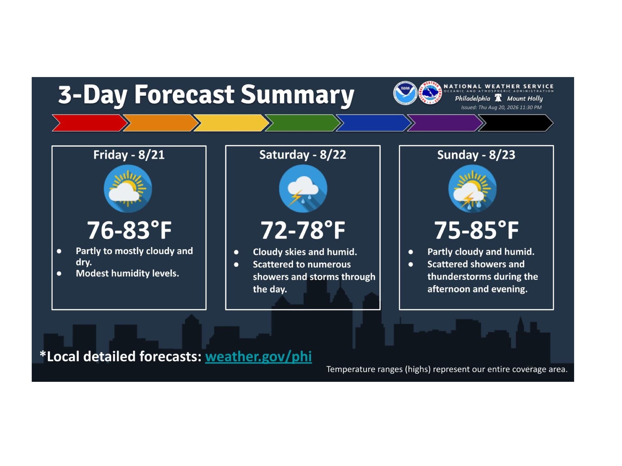
Following a weekend of showers, fair weather is expected to return to the Garden State on Monday and should last through the middle of the week.
Find out what's happening in Across New Jerseyfor free with the latest updates from Patch.
Here's the latest weekend forecast from the NWS:
NORTH JERSEY
- Saturday: A 20 percent chance of showers after 2 p.m. Mostly cloudy, with a high near 77. Light and variable wind becoming east around 5 MPH in the afternoon.
- Saturday Night: A chance of showers and thunderstorms. Mostly cloudy, with a low around 67. Light east wind. Chance of precipitation is 40%.
- Sunday: A 50 percent chance of showers and thunderstorms. Mostly cloudy, with a high near 81. Calm wind becoming southwest 5-8 MPH in the afternoon.
- Sunday Night: Mostly clear, with a low around 64. West wind around 6 MPH.
CENTRAL JERSEY
- Saturday: A chance of showers, with thunderstorms also possible after 5 p.m. Mostly cloudy, with a high near 77. Calm wind becoming east around 5 MPH. Chance of precipitation is 40%. New rainfall amounts of less than a tenth of an inch, except higher amounts possible in thunderstorms.
- Saturday Night: A chance of showers and thunderstorms, mainly after 1 a.m. Mostly cloudy, with a low around 65. Calm wind. Chance of precipitation is 50%. New rainfall amounts of less than a tenth of an inch, except higher amounts possible in thunderstorms.
- Sunday: A chance of showers and thunderstorms, mainly between 11 a.m. and 2 p.m. Cloudy, then gradually becoming mostly sunny, with a high near 83. Calm wind becoming southwest around 5 MPH in the afternoon. Chance of precipitation is 40%. New rainfall amounts of less than a tenth of an inch, except higher amounts possible in thunderstorms.
- Sunday Night: Mostly clear, with a low around 62. West wind around 5 MPH.
SOUTH JERSEY
- Saturday: Showers before 11 a.m., then a chance of showers and thunderstorms between 11 a.m. and noon, then showers likely and possibly a thunderstorm after noon. High near 79. East wind 5-10 MPH. Chance of precipitation is 80%. New rainfall amounts between a quarter and half of an inch possible.
- Saturday Night: Showers and thunderstorms likely, mainly before 3 a.m. Mostly cloudy, with a low around 68. East wind around 5 MPH. Chance of precipitation is 60%. New rainfall amounts between a quarter and half of an inch possible.
- Sunday: A chance of showers before 8 a.m., then a slight chance of showers and thunderstorms after 2 p.m. Mostly sunny, with a high near 84. West wind 5-10 MPH. Chance of precipitation is 30%. New rainfall amounts of less than a tenth of an inch, except higher amounts possible in thunderstorms.
- Sunday Night: Mostly clear, with a low around 67. West wind around 5 MPH.
Get more local news delivered straight to your inbox. Sign up for free Patch newsletters and alerts.