Weather
Snow Back In NJ's Forecast
A taste of spring will tease New Jersey this weekend but we could get another dose of snow to start the week.

For those begging for spring to arrive already, we're going to get a dose of warmer weather this weekend. But as a reminder it's still winter ... there is some snow in the forecast early next week for parts of New Jersey.
(We're sorry — we promise we don't want it either.)
The good news is more warm weather is headed our way later next week, the National Weather Service says.
Find out what's happening in Across New Jerseyfor free with the latest updates from Patch.
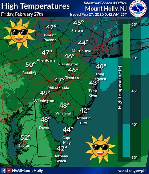
The National Weather Service is calling for temperatures in the upper 40s to around 50 degrees on Friday and in the mid-50s on Saturday before colder temperatures return late Saturday an arctic front moves in.
There is not a lot of moisture expected to be associated with it but there could be just enough to generate some snow north of I-78, the weather service said, with up to an inch possible. South of I-78 the possibility of precipitation is lower with rain or a rain/snow mix.
Find out what's happening in Across New Jerseyfor free with the latest updates from Patch.
"After precipitation exits, it will be noticeably colder on Sunday," the forecasters said.
More cold is expected to be in place Monday into Tuesday with an arctic high pressure system from Canada moving in. A couple of storm systems are possible, one on Monday into Monday evening and a second later Tuesday into Wednesday.
For the Monday system, weak low pressure is forecast to track east out of the Tennessee Valley along a stalled front, but the weather service says the strong, arctic high to the north is expected to keep the system to the south with it moving offshore near the Chesapeake region.
Some light snow is possible but the weather service said it's increasingly unlikely.
The potential Tuesday storm could take the same route, but it could be a mix of rain and snow as temperatures gradually warm up.
The weather service says "a significant warm-up is expected late next week, with highs in the 50s and 60s next weekend.
For this weekend, the northern part of the state will see the coldest temperatures, with highs just over 50 degrees on Saturday and two chances of snow, on Sunday afternoon and on Tuesday afternoon.
In the central part of New Jersey, temperatures are anticipated to be in the upper 40s on Friday and mid-50s on Saturday and a chance of snow on Sunday that could bring a half-inch or less. Later in the week the rain is expected to start washing away the lingering snow from last weekend.
The southern part of the state will see the warmest temperatures, with highs near 50 on Friday and in the upper 50s on Saturday and rain on Sunday and Tuesday.
Here is the day-by-day forecast for the state:
North Jersey
- Friday: Sunny, with a high near 46. Calm wind becoming south around 6 mph in the afternoon
- Friday night: Partly cloudy, with a low around 28. Light south wind.
- Saturday: Mostly sunny, with a high near 52. South wind 3 to 7 mph.
- Saturday night: Increasing clouds, with a low around 33. Light and variable wind becoming north around 6 mph after midnight.
- Sunday: Scattered snow showers before 1 p.m. Cloudy through mid-morning, then gradual clearing, with a high near 39. Northwest wind 7 to 10 mph. Chance of precipitation is 40 percent.
- Sunday night: Partly cloudy, with a low around 18.
- Monday: Mostly cloudy, with a high near 30.
- Monday night: Mostly cloudy, with a low around 20.
- Tuesday: A chance of rain and snow after 1 p.m. Mostly cloudy, with a high near 38. Chance of precipitation is 40 percent.
- Tuesday night: Rain likely. Cloudy, with a low around 32. Chance of precipitation is 70 percent.
- Wednesday: A 30 percent chance of rain. Partly sunny, with a high near 46.
- Wednesday night: Mostly cloudy, with a low around 34.
- Thursday: A 30 percent chance of rain. Cloudy, with a high near 47.
Central Jersey
- Friday: Sunny, with a high near 45. East wind around 5 mph becoming south in the afternoon.
- Friday night: Partly cloudy, with a low around 26. South wind around 5 mph becoming calm.
- Saturday: Mostly sunny, with a high near 54. Calm wind becoming southwest around 5 mph.
- Saturday night: Partly cloudy, with a low around 30. Calm wind.
- Sunday: A chance of snow, mixing with rain after 10 a.m., then gradually ending. Partly sunny, with a high near 40. North wind 5 to 10 mph, with gusts as high as 20 mph. Chance of precipitation is 30 percent. New snow accumulation of less than a half inch possible.
- Sunday night: Partly cloudy, with a low around 18.
- Monday: A chance of snow after 1 p.m. Mostly cloudy, with a high near 30. Chance of precipitation is 30 percent.
- Monday night: Mostly cloudy, with a low around 21.
- Tuesday: A chance of rain after 1 p.m. Mostly cloudy, with a high near 40. Chance of precipitation is 40percent.
- Tuesday night: Rain likely. Cloudy, with a low around 32. Chance of precipitation is 70 percent.
- Wednesday: A chance of rain. Mostly cloudy, with a high near 47. Chance of precipitation is 30 percent.
- Wednesday night: Mostly cloudy, with a low around 34.
- Thursday: Cloudy, with a high near 52.
South Jersey
- Friday:Sunny, with a high near 49. Calm wind becoming south around 5 mph.
- Friday night: Partly cloudy, with a low around 26. Calm wind.
- Saturday: Partly sunny, then gradually becoming sunny, with a high near 57. Calm wind becoming southwest around 5 mph.
- Saturday night: Partly cloudy, with a low around 32. Calm wind.
- Sunday: A slight chance of rain before 1 p.m. Partly sunny, with a high near 43. Southeast wind 5 to 10 mph becoming northwest in the afternoon. Winds could gust as high as 20 mph. Chance of precipitation is 20 percent.
- Sunday night: Partly cloudy, with a low around 19.
- Monday: A chance of snow after 1 p.m. Mostly cloudy, with a high near 33. Chance of precipitation is 30 percent.
- Monday night: Mostly cloudy, with a low around 21.
- Tuesday: A chance of rain. Mostly cloudy, with a high near 42. Chance of precipitation is 40 percent.
- Tuesday night: Rain likely. Cloudy, with a low around 34. Chance of precipitation is 70 percent.
- Wednesday: A chance of rain. Mostly cloudy, with a high near 50. Chance of precipitation is 40 percent.
- Wednesday night: Mostly cloudy, with a low around 36.
- Thursday: Mostly cloudy, with a high near 58.
Get more local news delivered straight to your inbox. Sign up for free Patch newsletters and alerts.