Weather
Hudson Valley Weather: New Details On Snow Accumulation Estimates, Timeline Released
Find out how much snow to expect in your area.

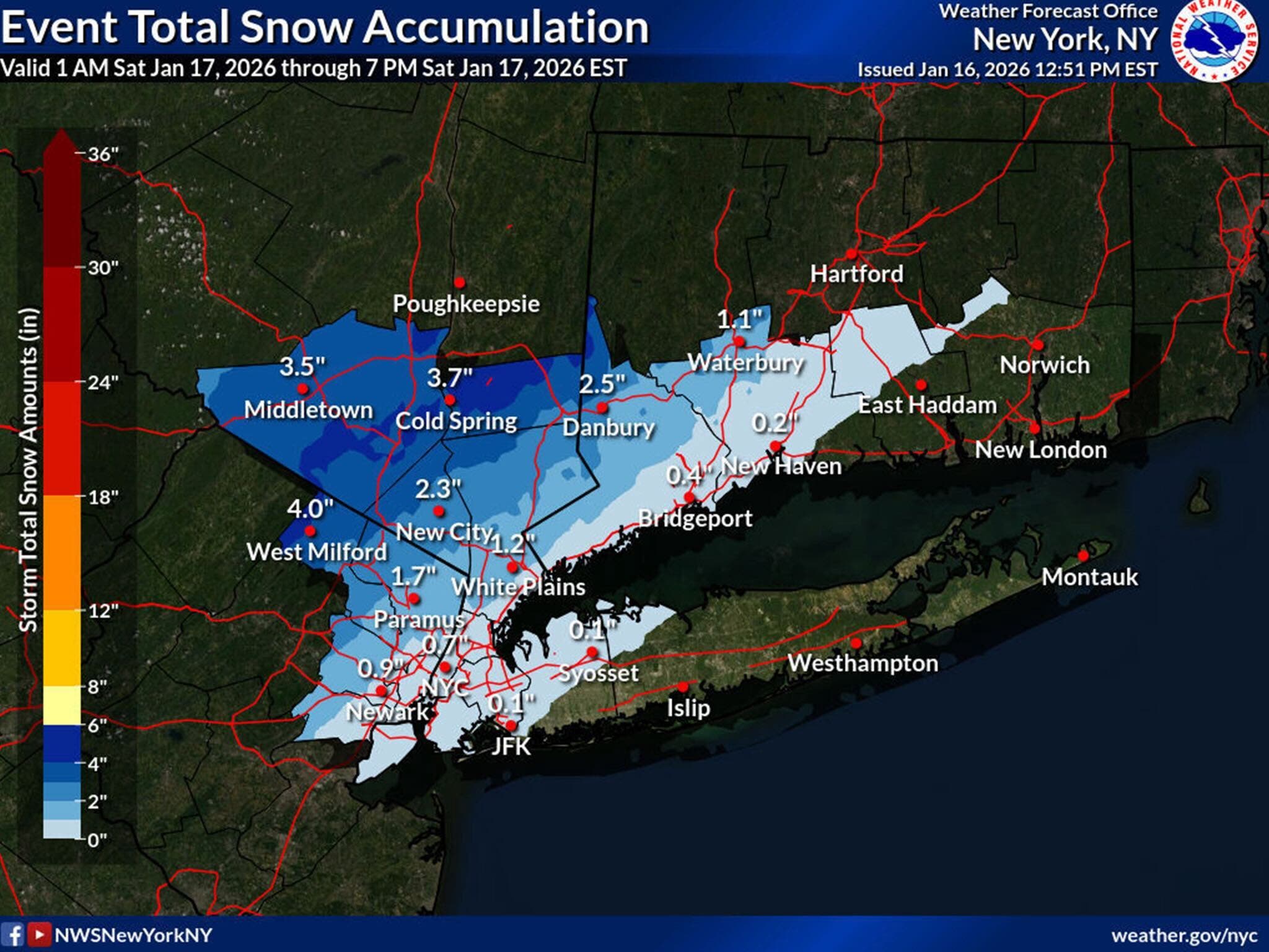
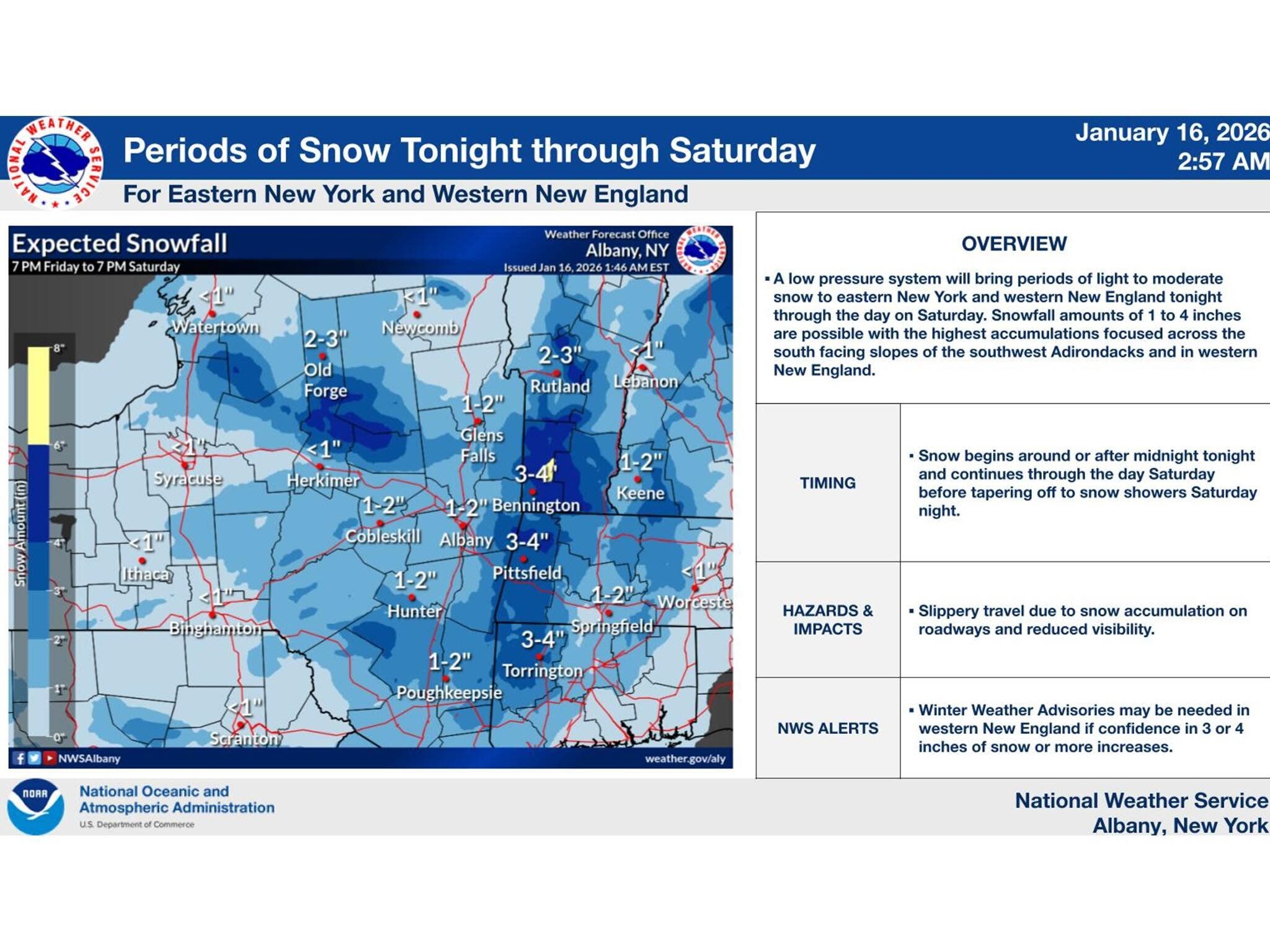
HUDSON VALLEY, NY — Widespread snow is in the forecast in the Hudson Valley for Saturday, with between one and four inches expected.
The National Weather Service on Friday issued winter weather advisories due to the upcoming snowfall.
Brian Frugis, a meteorologist with the National Weather Service based in Albany, said the snow will begin after midnight tonight and continue into Saturday afternoon.
Find out what's happening in Mid Hudson Valleyfor free with the latest updates from Patch.
Most of the Hudson Valley will get between one and three inches of snow, but some areas can expect to get four inches, according to Frugis.
The heaviest snowfall is expected in the southeastern and higher terrain areas, he said.
Find out what's happening in Mid Hudson Valleyfor free with the latest updates from Patch.
Roads could be slippery Saturday, and motorists should use caution, according to the advisories.
Meteorologists are also monitoring a coastal storm which may bring a chance for more snow in the region on Sunday, according to Frugis.
“Right now, it appears that it may be going out to sea, with little impact on the Hudson Valley,” Frugis said Friday afternoon.
The Martin Luther King Day holiday on Monday is expected to be dry and sunny, with high temperatures around 31 degrees.
Here are the forecast details for the Mid-Hudson Valley area via the National Weather Service:
This Afternoon: Partly sunny, with a high near 32. West wind 6 to 9 mph.
Tonight: Snow showers likely, mainly after 4 a.m. Increasing clouds, with a low around 25. Light south wind. Chance of precipitation is 70%. New snow accumulation of around an inch possible.
Saturday: Snow showers, mainly before 3 p.m. High near 36. South wind around 6 mph. Chance of precipitation is 80%. New snow accumulation of 2 to 4 inches possible.
Saturday Night: Increasing clouds, with a low around 26. Light southwest wind.
Sunday: A chance of snow showers before 10 a.m., then a chance of rain and snow showers between 10 a.m. and 4 p.m., then a chance of snow showers after 4 p.m. Cloudy, with a high near 36. Calm wind becoming southwest around 5 mph. Chance of precipitation is 30%. New precipitation amounts of less than a tenth of an inch possible.
Sunday Night: Partly cloudy, with a low around 17.
Martin Luther King Day: Mostly sunny, with a high near 31.
Here are the forecast details for the lower Hudson Valley area via the National Weather Service:
This Afternoon: Mostly sunny, with a high near 33. Wind chill values between 20 and 25. West wind 9 to 13 mph.
Tonight: A 40 percent chance of snow after 1 a.m. Increasing clouds, with a low around 28. Wind chill values between 20 and 25. South wind around 7 mph.
Saturday: Snow, mainly before 4 p.m. High near 38. South wind 5 to 8 mph. Chance of precipitation is 80%. New snow accumulation of less than one inch possible.
Saturday Night: A 20 percent chance of snow after 1 a.m. Mostly cloudy, with a low around 29. West wind 3 to 6 mph.
Sunday: A 50 percent chance of snow. Cloudy, with a high near 36. West wind 3 to 7 mph.
Sunday Night: Mostly cloudy, then gradually becoming mostly clear, with a low around 20.
Martin Luther King Day: Sunny, with a high near 31.
Get more local news delivered straight to your inbox. Sign up for free Patch newsletters and alerts.