Weather
Hudson Valley Weekend Weather: A Sunny Start, Then Snow: NWS
Find out the latest snow accumulation prediction and timeline, according to meteorologists.

HUDSON VALLEY, NY - The next chance for snow in the Hudson Valley is this weekend.
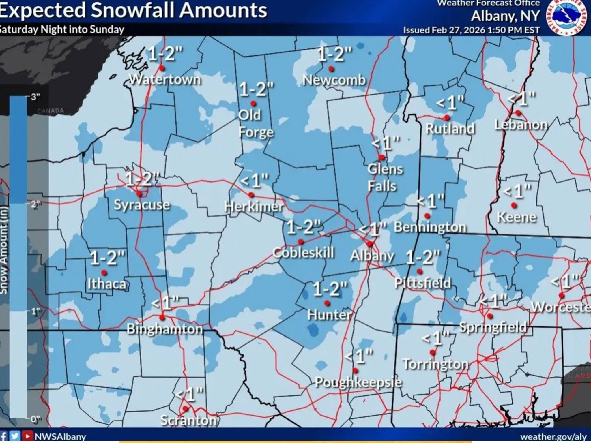
Saturday will be sunny, with highs in the upper 40s. The National Weather Service’s Albany office predicts light snow will fall across the region Saturday night into Sunday.
It anticipates between a coating and two inches of accumulation, with the potential for slippery travel conditions.
Find out what's happening in Mid Hudson Valleyfor free with the latest updates from Patch.
The higher amounts will be in northern sections of the Hudson Valley, according to the National Weather Service. Any snow will wind down on Sunday by the early afternoon.
Monday is expected to be dry and sunny, then another system will bring precipitation on Tuesday, forecasters said.
Find out what's happening in Mid Hudson Valleyfor free with the latest updates from Patch.
The National Weather Service predicts the Tuesday precipitation will start as snow, but will change over to rain Tuesday night.
Here are the forecast details for the Mid-Hudson Valley area via the National Weather Service:
Tonight: Patchy fog between 2 a.m. and 3 a.m. Otherwise, mostly clear, with a low around 28. Light south wind.
Saturday: Mostly sunny, with a high near 48. South wind 3 to 6 mph.
Saturday Night: Increasing clouds, with a low around 25. Calm wind.
Sunday: Snow likely, mainly before 1 p.m. Cloudy through mid morning, then gradual clearing, with a high near 37. North wind 3 to 8 mph. Chance of precipitation is 60%. New snow accumulation of less than one inch possible.
Sunday Night: Mostly clear, with a low around 10. Northwest wind 3 to 6 mph.
Monday: Mostly sunny, with a high near 28.
Monday Night: Partly cloudy, with a low around 12.
Tuesday: A chance of snow before 1 p.m., then a chance of rain and snow. Mostly cloudy, with a high near 39. Chance of precipitation is 50%.
Tuesday Night: Rain likely, mainly before 1 a.m. Cloudy, with a low around 32. Chance of precipitation is 60%.
Wednesday: Mostly cloudy, with a high near 47.
Here are the forecast details for the lower Hudson Valley area via the National Weather Service:
Tonight: Patchy fog after 3 a.m. Otherwise, increasing clouds, with a low around 27. Calm wind.
Saturday: Patchy fog before 7 a.m. Otherwise, mostly sunny, with a high near 45. Calm wind becoming southwest around 6 mph.
Saturday Night: Partly cloudy, with a low around 29. Calm wind becoming north around 5 mph after midnight.
Sunday: Snow showers likely before 4 p.m., then a slight chance of rain and snow showers. Cloudy, then gradually becoming mostly sunny, with a high near 38. North wind 6 to 10 mph. Chance of precipitation is 60%. New snow accumulation of less than a half inch possible.
Sunday Night: Mostly clear, with a low around 16.
Monday: Partly sunny, with a high near 29.
Monday Night: Partly cloudy, with a low around 18.
Tuesday: A chance of rain and snow before 1 p.m., then a chance of rain. Mostly cloudy, with a high near 39. Chance of precipitation is 50%.
Tuesday Night: Rain likely. Cloudy, with a low around 35. Chance of precipitation is 70%.
Wednesday: A 30 percent chance of rain. Mostly cloudy, with a high near 47.
Get more local news delivered straight to your inbox. Sign up for free Patch newsletters and alerts.