Weather
‘Significant Winter Storm’ Expected In Hudson Valley This Weekend
Find out exactly when meteorologists predict the storm could impact the region.

HUDSON VALLEY, NY — Meteorologists are honing in on the likely timeframe for an upcoming winter storm.
The National Weather Service reports the storm will impact the Hudson Valley region starting on Sunday and lasting into Monday.
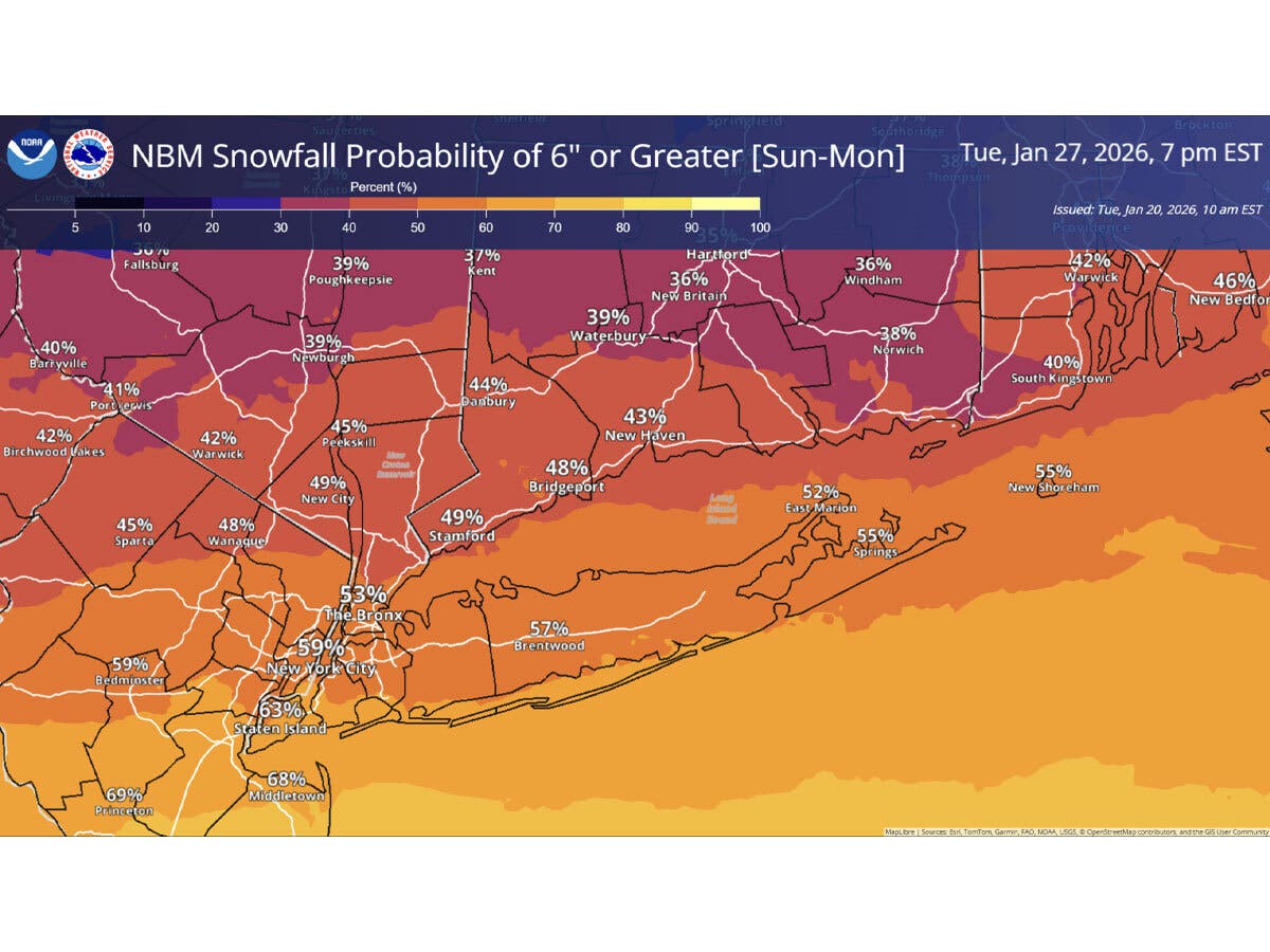
In a hazardous weather outlook issued Wednesday that includes southeast New York, it said, “Confidence is increasing in the potential for a significant winter storm to impact the area Sunday into Monday with accumulating snowfall.”
Find out what's happening in Mid Hudson Valleyfor free with the latest updates from Patch.
For Sunday, it is currently predicting a 60 to 70 percent chance of snow.
The National Weather Service’s New York City office reports snow in the Hudson Valley could begin early Sunday morning and last into a portion of Monday.
Find out what's happening in Mid Hudson Valleyfor free with the latest updates from Patch.
It indicated the exact timing and amounts will become clearer as the week progresses.
“We are monitoring a growing potential for a plowable snowfall event Sunday into Monday. There is a moderate potential we could exceed 6 inches of snow from a low pressure system that will pass to our south. Monitor the forecast for changes as we approach the weekend,” the National Weather Service reports.
The National Weather Service’s Weather Prediction Center urges people to start storm preparations now.
Meanwhile, in the short term, there is a chance for snow showers Wednesday night, then it is expected to be dry for Thursday through Saturday.
Thursday will be the warmest, with high temperatures reaching near 41 degrees. It then turns much colder, with Friday’s daytime highs in the upper 20s to low 30s, and Saturday’s high temperatures only reaching into the teens, according to the National Weather Service.
Here are the forecast details for the Mid-Hudson Valley area via the National Weather Service:
Today: Partly sunny, with a high near 29. South wind 6 to 9 mph, with gusts as high as 21 mph.
Tonight: A slight chance of snow showers before 10 p.m. Cloudy, then gradually becoming partly cloudy, with a low around 24. South wind around 6 mph. Chance of precipitation is 20%.
Thursday: Mostly sunny, with a high near 41. South wind 7 to 13 mph becoming west in the afternoon. Winds could gust as high as 24 mph.
Thursday Night: Partly cloudy, with a low around 17. West wind 3 to 6 mph.
Friday: Partly sunny, with a high near 29. Southwest wind 6 to 11 mph, with gusts as high as 23 mph.
Friday Night: Partly cloudy, with a low around 2.
Saturday: Mostly sunny, with a high near 14.
Saturday Night: A chance of snow after 1 a.m. Mostly cloudy, with a low around 3. Chance of precipitation is 30%.
Sunday: Snow likely. Mostly cloudy, with a high near 15. Chance of precipitation is 60%.
Sunday Night: A chance of snow. Mostly cloudy, with a low around 9. Chance of precipitation is 50%.
Monday: A chance of snow. Partly sunny, with a high near 21. Chance of precipitation is 30%.
Here are the forecast details for the lower Hudson Valley area via the National Weather Service:
Today: A 20 percent chance of snow after 4 p.m. Mostly cloudy, with a high near 30. Wind chill values between 15 and 20. South wind 6 to 9 mph.
Tonight: A 30 percent chance of snow, mainly between 7 p.m. and 1 a.m. Cloudy, then gradually becoming partly cloudy, with a low around 28. Wind chill values between 20 and 25. Southwest wind around 8 mph.
Thursday: Mostly sunny, with a high near 41. Wind chill values between 20 and 30. Southwest wind 8 to 13 mph.
Thursday Night: Partly cloudy, with a low around 23. Wind chill values between 15 and 20. West wind 7 to 9 mph.
Friday: Partly sunny, with a high near 31. West wind 6 to 13 mph, with gusts as high as 23 mph.
Friday Night: Partly cloudy, with a low around 7.
Saturday: Mostly sunny and cold, with a high near 15.
Saturday Night: A 40 percent chance of snow after 1 a.m. Mostly cloudy, with a low around 8.
Sunday: Snow likely. Mostly cloudy and cold, with a high near 18. Chance of precipitation is 70%.
Sunday Night: Snow likely. Mostly cloudy, with a low around 12. Chance of precipitation is 60%.
Monday: A 40 percent chance of snow. Partly sunny, with a high near 23.
Get more local news delivered straight to your inbox. Sign up for free Patch newsletters and alerts.


