Weather
Snow Accumulation Estimates Increase For Hudson Valley: Here Are The New Predictions
Find out the latest snowfall estimates, timeline for the upcoming major winter storm.

HUDSON VALLEY, NY — The weekend storm system is expected to bring 12 to 18 inches of snow to most of the Hudson Valley region, according to the latest National Weather Service projections.
A winter storm watch is in effect from Sunday morning through Monday evening for all of eastern New York, including the Hudson Valley.
“Snowfall rates may exceed one inch per hour at times, especially on Sunday night,” the National Weather Service said early Friday.
Find out what's happening in Mid Hudson Valleyfor free with the latest updates from Patch.
It anticipates the highest snowfall amounts will be in the Mid Hudson Valley, the eastern Catskills, and southwestern New England.
Some areas could get as much as two feet of snowfall, according to the National Weather Service in Albany.
Find out what's happening in Mid Hudson Valleyfor free with the latest updates from Patch.
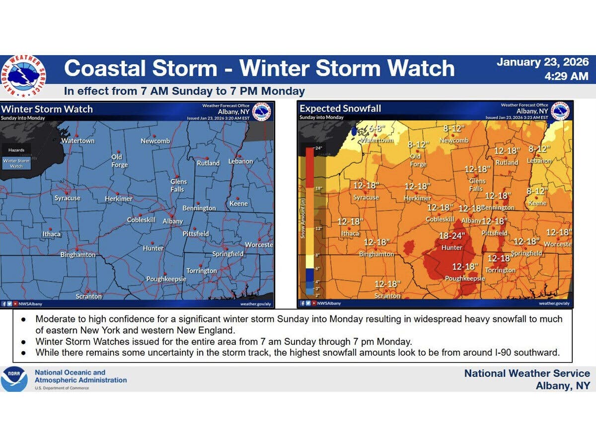
In southern parts of the Hudson Valley, such as Orange, Putnam, Rockland and Westchester counties, total snow accumulations are expected to be less, or between eight and 14 inches, though locally higher amounts are possible, the National Weather Service said Friday.
The snow may mix with or change over to sleet in southern areas, limiting accumulations to the lower end of this range. Higher totals are expected in the interior Hudson Valley.
Travel is expected to be difficult, with slick roads and reduced visibility, and the National Weather Services advises people to consider delaying travel if possible. If you must travel, take a winter storm kit, with tire chains, booster cables, flashlight, shovel, blankets, extra clothing, a first aid kit, food and water, according to the National Weather Service.
Here are the forecast details for the Mid-Hudson Valley area via the National Weather Service, as of Friday:
Today: Mostly sunny, with a high near 30. West wind 13 to 16 mph, with gusts as high as 28 mph.
Tonight: Mostly clear, with a low around 3. Wind chill values as low as -7. Northwest wind 7 to 13 mph, with gusts as high as 24 mph.
Saturday: Increasing clouds, with a high near 14. Wind chill values as low as -8. Northwest wind around 6 mph.
Saturday Night: A slight chance of snow after 1 a.m. Mostly cloudy, with a low around 6. Calm wind. Chance of precipitation is 20%.
Sunday: Snow. The snow could be heavy at times. High near 17. Calm wind becoming northeast around 6 mph in the afternoon. Chance of precipitation is 100%.
Sunday Night: Snow. The snow could be heavy at times. Low around 13. Chance of precipitation is 100%.
Monday: Snow, mainly before 1 p.m. High near 24. Chance of precipitation is 80%.
Monday Night: Mostly cloudy, with a low around 4.
Tuesday: Mostly sunny, with a high near 21.
Here are the forecast details for the lower Hudson Valley area via the National Weather Service, as of Friday:
Today: Mostly sunny, with a high near 32. Wind chill values between 15 and 20. West wind 11 to 14 mph, with gusts as high as 26 mph.
Tonight: Mostly clear, with a low around 7. Wind chill values between -5 and 5. Northwest wind 10 to 14 mph, with gusts as high as 28 mph.
Saturday: Mostly sunny and cold, with a high near 17. Wind chill values between -10 and zero. Northwest wind 7 to 10 mph.
Saturday Night: A 40 percent chance of snow after 1 a.m. Cloudy, with a low around 11. Wind chill values between 5 and 10. North wind around 6 mph.
Sunday: Snow. The snow could be heavy at times. High near 24. Northeast wind 7 to 14 mph, with gusts as high as 25 mph. Chance of precipitation is 100%. New snow accumulation of 7 to 11 inches possible.
Sunday Night: Snow. Temperature falling to near 19 by 10 p.m., then rising to around 23 during the remainder of the night. Chance of precipitation is 100%. New snow accumulation of 3 to 5 inches possible.
Monday: Snow likely, mainly before 1 p.m. Cloudy, with a high near 26. Chance of precipitation is 70%.
Monday Night: Partly cloudy, with a low around 8.
Tuesday: Mostly sunny and cold, with a high near 20.
Get more local news delivered straight to your inbox. Sign up for free Patch newsletters and alerts.