Weather
Snow To Impact Evening Commute In Hudson Valley: Find Out The Latest Timeline
Meteorologists are predicting a significant warm-up later this week.

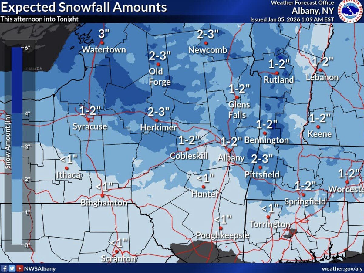
HUDSON VALLEY, NY — Light snow is impacting much of the region and will continue for the evening commute, according to the National Weather Service.
It advised motorists to be cautious due to the potential for slippery conditions.
“Take it slow, give yourself more travel time,” the National Weather Service said. “While accumulations will remain on the light side, some slippery conditions will still be possible for this evening's commute.”
Find out what's happening in Mid Hudson Valleyfor free with the latest updates from Patch.
The snow will continue through the afternoon and then taper off tonight, according to the National Weather Service. Most of the Hudson Valley region is expected to get from a coating to an inch of snowfall before the precipitation ends. Travelers are advised that more snow is expected to the north in New York State.
Following this system, another one will bring snow and a wintry mix, which will change to just rain, from Tuesday evening into Wednesday. This will bring another chance for slick travel conditions, particularly in higher elevations, according to the National Weather Service.
Find out what's happening in Mid Hudson Valleyfor free with the latest updates from Patch.
High temperatures will be in the mid to upper 30s on Tuesday, then the region’s daytime highs will rise to the mid to upper 40s from Wednesday through Friday, the National Weather Service predicts.
Here are the forecast details for the Mid-Hudson Valley area via the National Weather Service:
This Afternoon: A chance of snow, mainly before 4 p.m. Cloudy, with a high near 30. South wind around 6 mph. Chance of precipitation is 30%. Total daytime snow accumulation of less than a half inch possible.
Tonight: Mostly cloudy, with a low around 23. Light south wind.
Tuesday: Mostly cloudy, with a high near 37. Calm wind.
Tuesday Night: Rain likely, mainly between 7 p.m and 1 a.m. Cloudy, with a low around 31. Calm wind. Chance of precipitation is 70%. New precipitation amounts of less than a tenth of an inch possible.
Wednesday: Partly sunny, with a high near 44. Light and variable wind becoming west 5 to 7 mph in the morning.
Wednesday Night: Mostly cloudy, with a low around 28.
Thursday: Mostly sunny, with a high near 44.
Thursday Night: Mostly cloudy, with a low around 32.
Friday: A chance of showers before 1 p.m., then rain likely after 1 p.m. Mostly cloudy, with a high near 48. Chance of precipitation is 60%.
Here are the forecast details for the lower Hudson Valley area via the National Weather Service:
This Afternoon: A 20 percent chance of snow before 4pm. Cloudy, with a high near 33. South wind around 6 mph.
Tonight: Mostly cloudy, with a steady temperature around 31. South wind around 6 mph becoming light and variable after midnight.
Tuesday: A 20 percent chance of rain after 4pm. Mostly cloudy, with a high near 38. Light and variable wind.
Tuesday Night: Rain likely, mainly between 7pm and 1am. Cloudy, with a low around 34. Calm wind becoming east around 5 mph after midnight. Chance of precipitation is 60%.
Wednesday: Partly sunny, with a high near 45. West wind 7 to 11 mph, with gusts as high as 25 mph.
Wednesday Night: Partly cloudy, with a low around 31.
Thursday: Mostly sunny, with a high near 45.
Thursday Night: Mostly cloudy, with a low around 34.
Friday: A 50 percent chance of rain. Mostly cloudy, with a high near 51.
Get more local news delivered straight to your inbox. Sign up for free Patch newsletters and alerts.