Weather
Temperature Drop, High Winds, Snow In Hudson Valley Forecast: NWS
Find out the latest weather prediction for the rest of the work week and upcoming weekend.

HUDSON VALLEY, NY — The region will see a big drop in temperature and higher winds as today progresses, according to meteorologists.
“There may still be some clouds at times through this evening, but overall the main story through tonight will be colder air working into the area along with gusty west winds,” the National Weather Service said.
Temperatures will dip as low as 16 degrees tonight, with wind gusts reaching 24 to 32 miles per hour, making it feel even colder, according to the National Weather Service. The wind chill could make it feel like the single digits.
Find out what's happening in Mid Hudson Valleyfor free with the latest updates from Patch.
During the day Friday, temperatures will reach around 33 degrees under mostly sunny skies, though it will continue to be windy, with gusts again up to 32 miles per hour, forecasters said. The winds will calm down later Friday, meteorologists said.
There is a chance for snow in the Hudson Valley on Saturday, the National Weather Service reports.
Find out what's happening in Mid Hudson Valleyfor free with the latest updates from Patch.
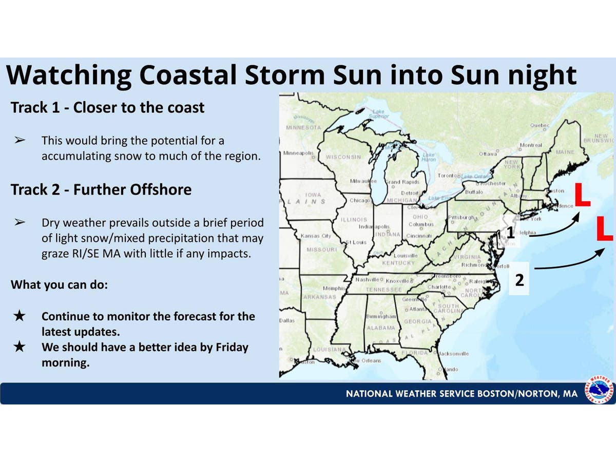
Forecasters are closely monitoring the track of a coastal storm which could potentially bring more snow to the region on Sunday.
The National Weather Service’s Boston office says it is tracking the coastal storm Sunday to Sunday night.
“A track closer to the coast would bring accumulating snow to much of (Southern New England)...while a further offshore track would result in little if any snow,” the National Weather Service said.
It anticipates having a better handle on the storm’s track on Friday.
Martin Luther King Day is expected to be sunny, with high temperatures in the low 30s.
Here are the forecast details for the Mid-Hudson Valley area via the National Weather Service:
This Afternoon: Mostly sunny, with a temperature falling to around 30 by 5 p.m. Southwest wind around 11 mph, with gusts as high as 24 mph.
Tonight: Partly cloudy, with a low around 16. West wind 8 to 10 mph, with gusts as high as 24 mph.
Friday: Mostly sunny, with a high near 33. West wind 6 to 10 mph, with gusts as high as 26 mph.
Friday Night: A slight chance of snow showers after 1 a.m. Mostly cloudy, with a low around 25. South wind around 6 mph. Chance of precipitation is 20%.
Saturday: A chance of snow showers before 1 p.m., then a chance of snow after 1 p.m. Mostly cloudy, with a high near 38. South wind 3 to 6 mph. Chance of precipitation is 50%.
Saturday Night: Mostly cloudy, with a low around 26.
Sunday: Partly sunny, with a high near 34.
Sunday Night: Partly cloudy, with a low around 17.
Martin Luther King Day: Mostly sunny, with a high near 30.
Here are the forecast details for the lower Hudson Valley area via the National Weather Service:
This Afternoon: Mostly sunny, with a temperature falling to around 32 by 5 p.m. Wind chill values between 20 and 30. West wind 13 to 16 mph, with gusts as high as 28 mph.
Tonight: Partly cloudy, with a low around 20. Wind chill values between 5 and 15. West wind 14 to 18 mph, with gusts as high as 32 mph.
Friday: Sunny, with a high near 33. Wind chill values between 5 and 15. West wind 10 to 17 mph, with gusts as high as 32 mph.
Friday Night: A 30 percent chance of snow after 1 a.m. Increasing clouds, with a low around 28. Wind chill values between 20 and 25. Southwest wind 5 to 7 mph.
Saturday: A chance of snow before 4 p.m., then a chance of rain and snow. Mostly cloudy, with a high near 39. South wind 5 to 7 mph. Chance of precipitation is 50%.
Saturday Night: Mostly cloudy, with a low around 29.
Sunday: Mostly cloudy, with a high near 34.
Sunday Night: Partly cloudy, with a low around 20.
Martin Luther King Day: Sunny, with a high near 31.
Get more local news delivered straight to your inbox. Sign up for free Patch newsletters and alerts.