Weather
Tornado Watch Issued In Eastern PA
Scattered wind gusts up to 70 miles per hour are likely, forecasters said.


A tornado watch has been issued for all of southeastern Pennsylvania and parts of the wider region until 9 p.m. Tuesday night, the National Weather Service announced.
A watch means that weather conditions could lead to the formation of tornadoes. A tornado warning will be issued if tornadoes are imminent.
Scattered wind gusts up to 70 miles per hour are likely, and ping pong sized hail is possible.
Find out what's happening in Across Pennsylvaniafor free with the latest updates from Patch.
.jpg)
There is also an increasing risk of damaging winds, hail, torrential rain, and flooding in the greater Philadelphia area Tuesday, according to forecasters.
The incoming storm has placed the region in the "enhanced risk" category Tuesday, National Weather Service said, meaning that scattered to numerous severe storms are considered probable.
Find out what's happening in Across Pennsylvaniafor free with the latest updates from Patch.
"A high risk for severe thunderstorms is expected along the Interstate 95 corridor from Washington, D.C. to Philadelphia," Accuweather said.
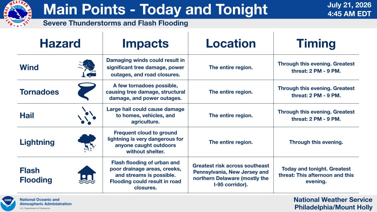
Some storms will impact the area Tuesday morning, but the bulk of the impacts will come later in the afternoon and evening, forecasters said. Major impacts are expected between 2 p.m. and 9 p.m.
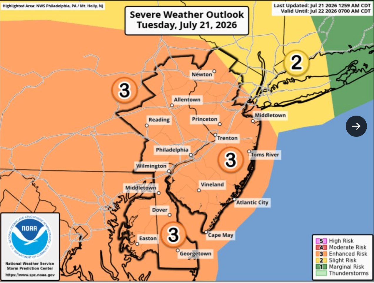
A flood watch is in place for the entire region until 2 a.m. Wednesday. Rainfall could be torrential, with up to 2 to 3 inches of rain falling per hour in the most heavily impacted areas. Urban areas are particularly vulnerable.
Multiple tornadoes and large hail are also possible throughout the region. Severe winds up to 75 miles per hour could cause damage to trees and structures.
Here's the full forecast for the Philadelphia area over the coming week, according to the National Weather Service:
Tuesday
Showers likely and possibly a thunderstorm before 10 a.m., then showers and thunderstorms likely, mainly after 4 p.m. Mostly cloudy, with a high near 86. South wind 10 to 15 mph. Chance of precipitation is 60 percent. New rainfall amounts between a quarter and half of an inch possible.
Tuesday Night
Showers and thunderstorms before midnight, then showers likely and possibly a thunderstorm between midnight and 1 a.m., then a chance of showers and thunderstorms after 1 a.m. Some of the storms could be severe and produce heavy rainfall. Low around 71. Southwest wind around 10 mph, with gusts as high as 20 mph. Chance of precipitation is 90 percent. New rainfall amounts between a half and three quarters of an inch possible.
Wednesday
A chance of showers and thunderstorms, mainly after 2 p.m. Partly sunny, with a high near 86. Southwest wind around 10 mph, with gusts as high as 20 mph. Chance of precipitation is 40 percent. New rainfall amounts of less than a tenth of an inch, except higher amounts possible in thunderstorms.
Wednesday Night
A chance of showers and thunderstorms before 8 p.m. Partly cloudy, with a low around 65. North wind around 5 mph. Chance of precipitation is 30 percent. New precipitation amounts of less than a tenth of an inch, except higher amounts possible in thunderstorms.
Thursday
Sunny, with a high near 81. North wind 5 to 10 mph.
Thursday Night
Clear, with a low around 63.
Friday
Sunny, with a high near 83.
Friday Night
Partly cloudy, with a low around 64.
Saturday
Mostly sunny, with a high near 82.
Saturday Night
Partly cloudy, with a low around 65.
Sunday
Mostly sunny, with a high near 85.
Sunday Night
A chance of showers. Partly cloudy, with a low around 68. Chance of precipitation is 30 percent.
Monday
A chance of showers and thunderstorms. Partly sunny, with a high near 86. Chance of precipitation is 50 percent.
Get more local news delivered straight to your inbox. Sign up for free Patch newsletters and alerts.