Weather
Weather Pattern Shift Could Impact Weekend Plans: See Latest Philly Area Forecast
Significant shifts in the weather pattern are in the forecast.


Summerlike weather may descend on much of the greater Philadelphia area Friday before two rounds of storms threaten the region, according to forecasters.
Temperatures will surge into the upper 80s Friday, bring what the National Weather Service speculated could be "summer's last gasp" to the region.
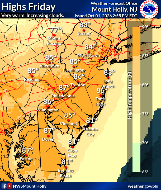
"Widespread heavy rainfall is not expected," Accuweather said. "In cities like Philadelphia and New York City, the front may hold off long enough for summerlike warmth to surge north, sending high temperatures into the 80s."
Find out what's happening in Across Pennsylvaniafor free with the latest updates from Patch.
The heat comes ahead the first round of storms on Friday night, with rain and some thunderstorms possible before 1 a.m. Storms are not expected to be severe. There is a 40 percent chance of precipitation, and accumulation is not expected to exceed a tenth of an inch except where thunderstorms hit directly.
The storms will sweep milder temperatures into the area on Saturday, with a high of just 72. Another round of storms may approach Saturday night into Sunday.
Find out what's happening in Across Pennsylvaniafor free with the latest updates from Patch.
"Tropical moisture is expected to advance farther north from late Saturday afternoon into Sunday, reaching parts of the mid-Atlantic," Accuweather added. "However, dry Canadian air advancing south should keep most of the rain south of the Interstate 80 corridor, where locally heavy rainfall can occur."
These storms are also not expected to be severe. As of early Friday, the forecast for Saturday night into Sunday calls for less than a tenth of an inch of rain, with a 20 to 50 percent chance of precipitation.
But that front will give way to markedly colder temperatures early next week, with lows dropping into the 40s and possibly even 30s in some parts of the region.
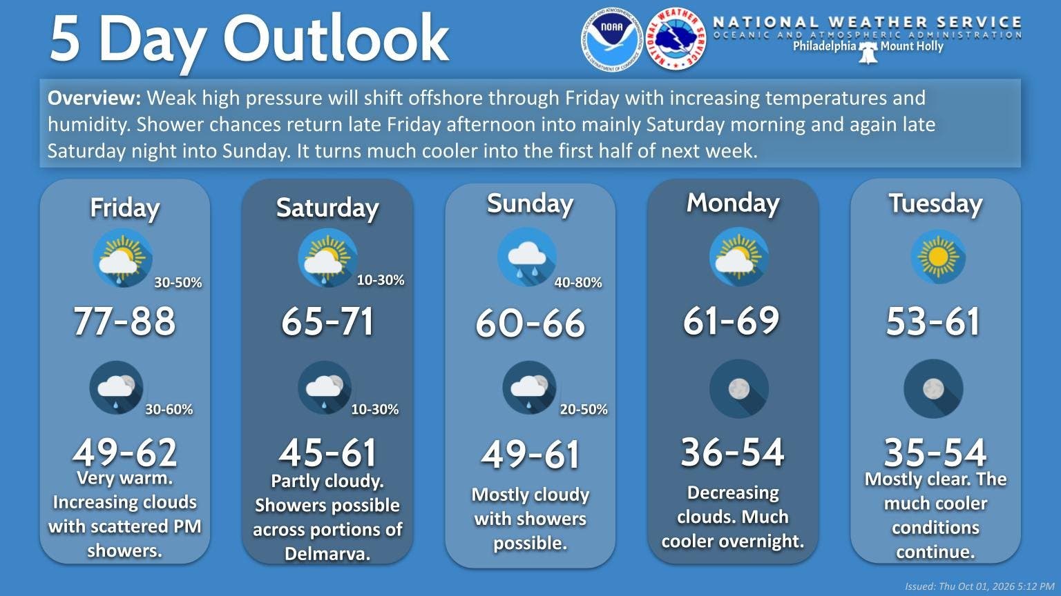
Here's the full forecast for the coming week:
Friday
A chance of showers and thunderstorms after 5 p.m. Mostly sunny, with a high near 86. Southwest wind 5 to 10 mph. Chance of precipitation is 30 percent. New rainfall amounts of less than a tenth of an inch, except higher amounts possible in thunderstorms.
Friday Night
A chance of showers and thunderstorms before 1 a.m., then a slight chance of showers between 1 a.m. and 2 a.m. Mostly cloudy, with a low around 60. West wind 5 to 10 mph becoming north after midnight. Chance of precipitation is 40 percent. New precipitation amounts of less than a tenth of an inch, except higher amounts possible in thunderstorms.
Saturday
Partly sunny, with a high near 72. Northeast wind around 5 mph.
Saturday Night
Increasing clouds, with a low around 56. East wind around 5 mph becoming calm.
Sunday
A chance of showers. Mostly cloudy, with a high near 67. East wind around 5 mph. Chance of precipitation is 50 percent. New precipitation amounts of less than a tenth of an inch possible.
Sunday Night
A slight chance of showers before 2 a.m. Mostly cloudy, with a low around 58. Chance of precipitation is 20 percent.
Monday
Mostly sunny, with a high near 70.
Monday Night
Mostly clear, with a low around 48.
Tuesday
Sunny, with a high near 61.
Tuesday Night
Clear, with a low around 45.
Wednesday
Sunny, with a high near 64.
Wednesday Night
Mostly clear, with a low around 49.
Thursday
Sunny, with a high near 69.
Get more local news delivered straight to your inbox. Sign up for free Patch newsletters and alerts.