Weather
Tornadoes Possible As Severe Thunderstorm Watch Issued In Philly Area
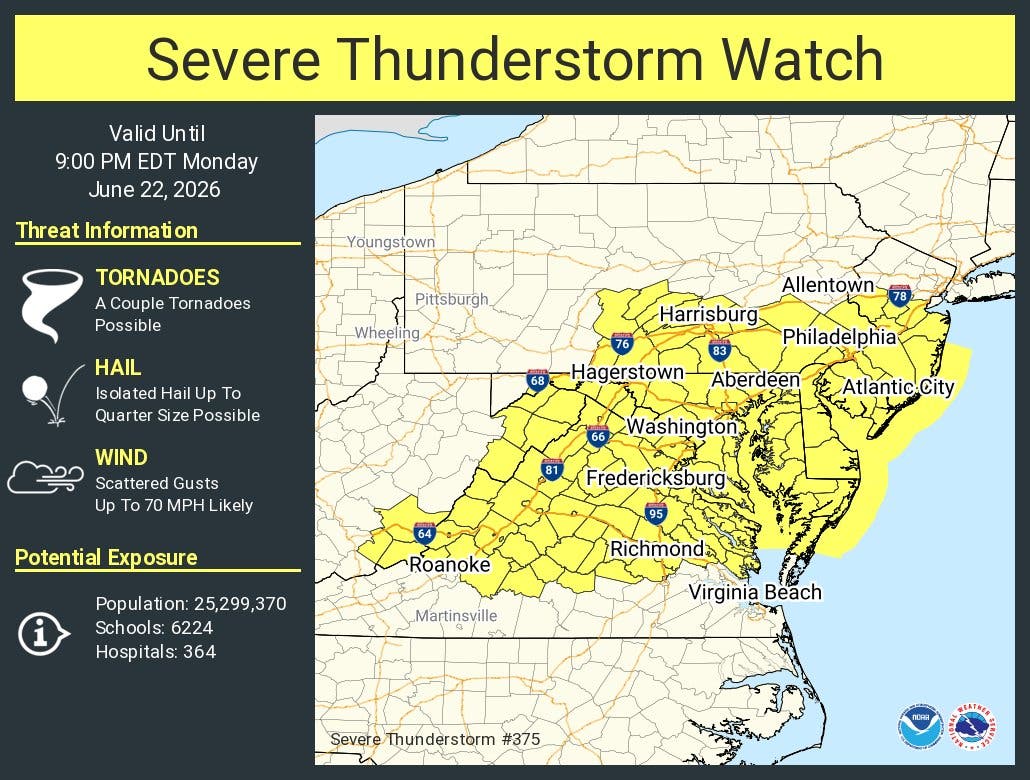
Damaging wind gusts and an isolated tornado are also possible, forecasters said.

Multiple tornadoes are possible Monday, the National Weather Service said, as a severe thunderstorm watch was issued for all of southeastern Pennsylvania Monday afternoon.
In addition to tornadoes and torrential rains, isolated, quarter-sized hail and 70 mile-per-hour winds are also possible.
A watch indicates severe impacts are possible. Warnings, which could be forthcoming later Monday, indicate they are imminent.
Find out what's happening in Across Pennsylvaniafor free with the latest updates from Patch.
"Please take these storms seriously today," the National Weather Service's Mt. Holly, New Jersey branch shared.
It comes hours after a flood watch was also issued for the region. That watch went into effect at 2 p.m. The height of the storm is expected between 3 p.m. and 11 p.m.
Find out what's happening in Across Pennsylvaniafor free with the latest updates from Patch.
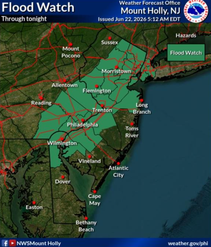
Rain could fall at a rate of up 1 to 2 inches per hour, the National Weather Service said.
"While we are starting quiet this morning, the day will not end that way," the agency's Mt. Holly, New Jersey branch shared. "We still expect scattered severe thunderstorms along with some instances of flash flooding late this afternoon and this evening. Be weather-aware later today and tonight."
Poor drainage areas and urban areas at the highest risk of flooding.
The storms could impact the scheduled World Cup Game at Lincoln Financial Field today between France and Iraq. It's set for 5 p.m.
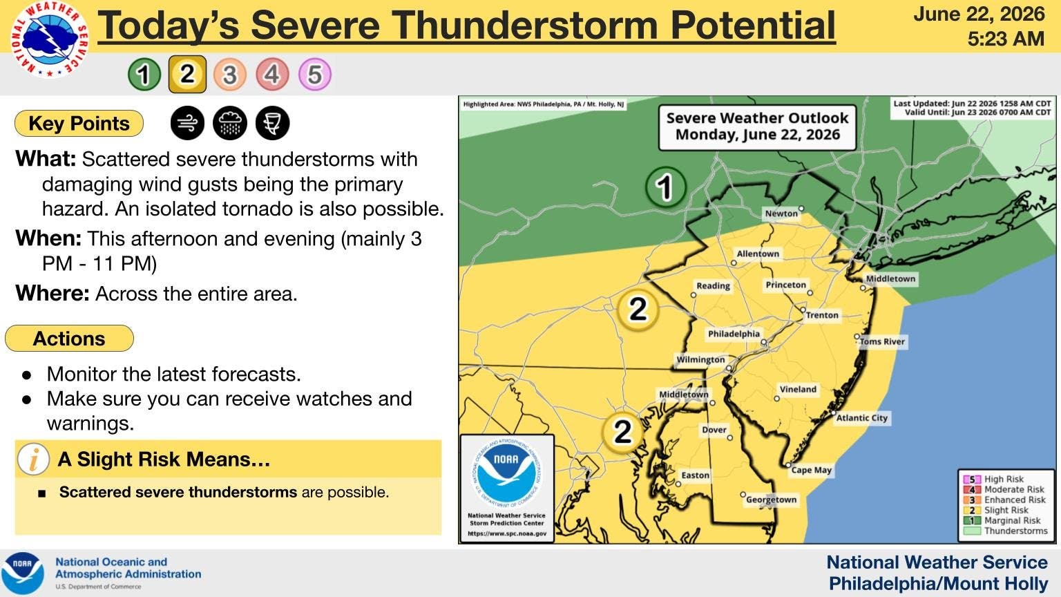
Officials say there is high confidence in the current forecast, with the whole region under a "level 2" risk, according to the National Weather Service.
Here's the full forecast for the Philadelphia area, according to the National Weather Service:
Monday
A chance of showers before 1 p.m., then a chance of showers and thunderstorms between 1 p.m. and 5 p.m., then showers and possibly a thunderstorm after 5 p.m. Some of the storms could be severe and produce heavy rainfall. High near 84. East wind 5 to 15 mph becoming south in the afternoon. Chance of precipitation is 80 percent. New rainfall amounts between a quarter and half of an inch possible.
Monday Night
Showers and possibly a thunderstorm before 11 p.m., then a chance of showers and thunderstorms between 11 p.m. and 2 a.m., then showers likely and possibly a thunderstorm after 2 a.m. Some of the storms could be severe and produce heavy rainfall. Low around 68. Southeast wind 5 to 10 mph becoming southwest after midnight. Chance of precipitation is 90 percent. New rainfall amounts between a quarter and half of an inch possible.
Tuesday
A chance of showers after 3 p.m. Cloudy, then gradually becoming mostly sunny, with a high near 80. North wind around 10 mph, with gusts as high as 20 mph. Chance of precipitation is 50 percent. New precipitation amounts between a tenth and quarter of an inch possible.
Tuesday Night
Mostly clear, with a low around 64. Northwest wind around 10 mph, with gusts as high as 20 mph.
Wednesday
Sunny, with a high near 85. Northwest wind 5 to 10 mph.
Wednesday Night
Mostly clear, with a low around 65.
Thursday
Mostly sunny, with a high near 89.
Thursday Night
A chance of showers and thunderstorms between 8 p.m. and 2 a.m., then a chance of showers after 2 a.m. Mostly cloudy, with a low around 67. Chance of precipitation is 40 percent.
Friday
A chance of showers, with thunderstorms also possible after 2 p.m. Partly sunny, with a high near 87. Chance of precipitation is 50 percent.
Friday Night
A chance of showers and thunderstorms before 2 a.m. Mostly cloudy, with a low around 68. Chance of precipitation is 30 percent.
Saturday
A chance of showers. Mostly sunny, with a high near 85. Chance of precipitation is 30 percent.
Saturday Night
A chance of showers. Partly cloudy, with a low around 68. Chance of precipitation is 30 percent.
Sunday
Mostly sunny, with a high near 87.
Get more local news delivered straight to your inbox. Sign up for free Patch newsletters and alerts.