Weather
Forecasters Watching Possible 'Major' Storm This Weekend
A few warmer days this week could give way to accumulating snow from a new winter storm in the Philadelphia region.

A winter storm front is heading to the mid-Atlantic region this week, bringing the potential for more snow to the greater Philadelphia area. However, the front remains highly variable and could also bring nothing at all, according to forecasters.
Accuweather calls the front, which would arrive sometime around Saturday night and continue through Sunday, "complicated."
"There are a lot of pieces to the puzzle that would have to come together at the right time for a major storm to unfold and bring heavy snow," Accuweather Meteorologist Brandon Buckingham said.
Find out what's happening in Across Pennsylvaniafor free with the latest updates from Patch.
Both the air temperature and the track of the storm will be the deciding factors on snow or rain or nothing, and forecasters may not have a much better idea until they see conditions closer to when the storm arrives.
"One significant problem we see right out of the chute is the lack of cold air around the time the storm is forecast to develop," AccuWeather Chief Meteorologist Jon Porter said.
Find out what's happening in Across Pennsylvaniafor free with the latest updates from Patch.
The storm track will also dictate if there is the possibility for accumulating snow in the Philadelphia region. AccuWeather noted that if the storm travels well inland of the coast, it will pull too much warm air into the I-95 zone for snow and might even make it too warm for an all-out snowstorm in our area.
If the storm develops the right way, several inches of accumulation could happen in the region, according to AccuWeather.
In the meantime, the region will see a few rainy and foggy days this week ahead of the storm, with some warmer weather.
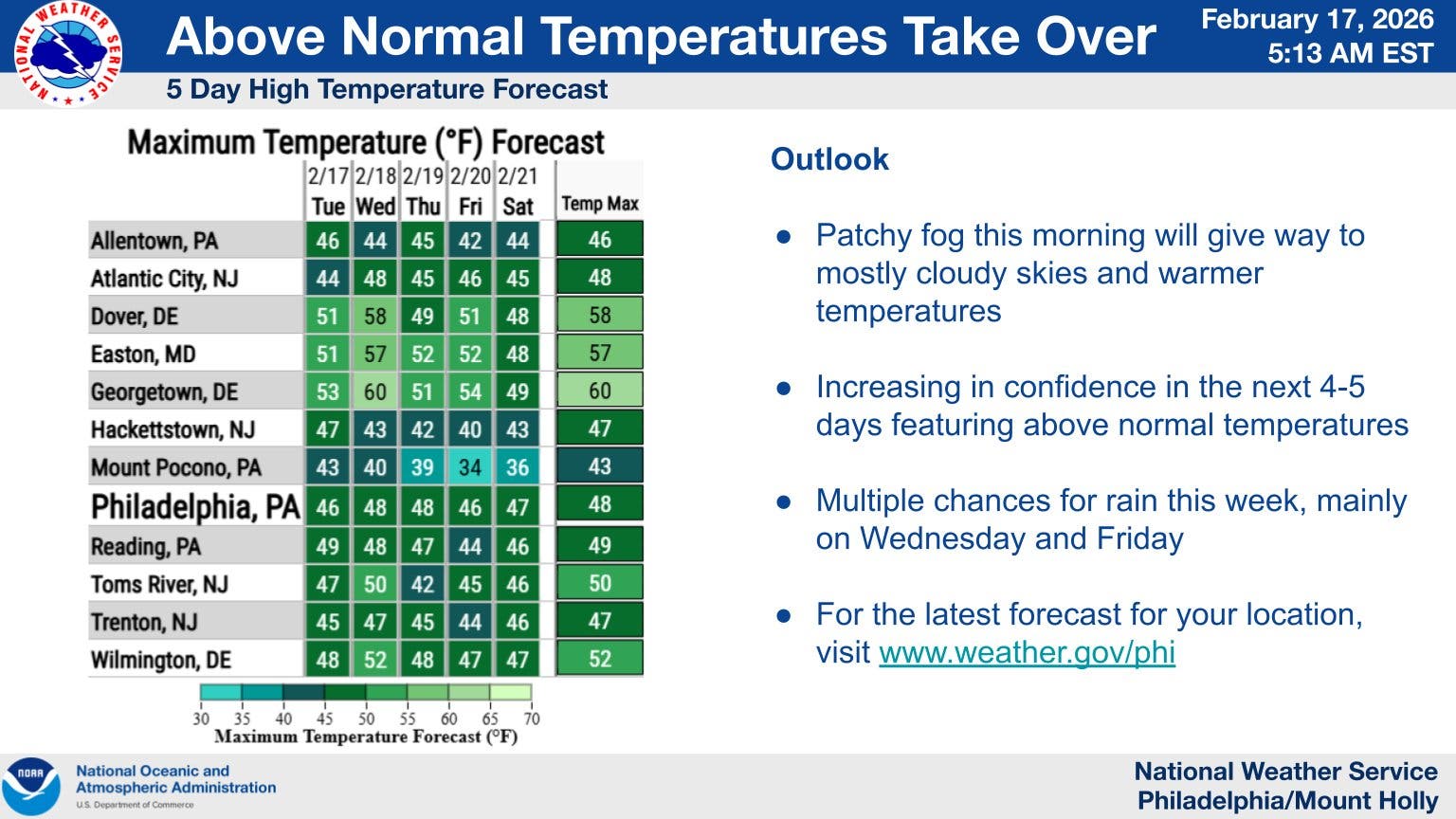
Highs will rise to 45 on Wednesday, with rain likely during the day and into the evening. There's a lesser chance of rain on Thursday morning, with a high of 43, before a near-certainty of rain Thursday night and again Friday morning.
Saturday looks to be a bizarre intermediary day between the storms, with forecasters calling for 50 degrees and sunny, before the winter storm potentially arrives in the evening.
Here's the full forecast for the coming week, according to the National Weather Service:
Wednesday
Rain likely, mainly between 3 p.m. and 5 p.m. Patchy fog before noon. Otherwise, cloudy, with a high near 45. Calm wind becoming north around 5 mph. Chance of precipitation is 60 percent. New precipitation amounts of less than a tenth of an inch possible.
Wednesday Night
A chance of rain, mainly before 8 p.m. Patchy fog before 3 a.m., then patchy fog after 4 a.m.. Otherwise, mostly cloudy, with a low around 37. Calm wind becoming north around 5 mph. Chance of precipitation is 30 percent. New precipitation amounts of less than a tenth of an inch possible.
Thursday
A chance of rain after 1 p.m. Patchy fog before 10 a.m. Otherwise, cloudy, with a high near 43. East wind around 5 mph. Chance of precipitation is 40 percent. New precipitation amounts of less than a tenth of an inch possible.
Thursday Night
Rain. Low around 38. East wind around 5 mph. Chance of precipitation is 80 percent. New precipitation amounts between a quarter and half of an inch possible.
Friday
Rain, mainly before 1 p.m. High near 46. East wind around 5 mph. Chance of precipitation is 90 percent. New precipitation amounts between a quarter and half of an inch possible.
Friday Night
A slight chance of rain before 1 a.m. Mostly cloudy, with a low around 37. Chance of precipitation is 20 percent.
Saturday
Partly sunny, with a high near 50.
Saturday Night
A chance of rain and snow after 1am. Mostly cloudy, with a low around 34. Chance of precipitation is 30 percent.
Sunday
Rain and snow likely, becoming all snow after 1 p.m. Mostly cloudy, with a high near 40. Chance of precipitation is 60 percent.
Sunday Night
A chance of snow. Mostly cloudy, with a low around 29. Chance of precipitation is 50%.
Monday
A chance of snow. Mostly cloudy, with a high near 39. Chance of precipitation is 30%.
Monday Night
Partly cloudy, with a low around 23.
Tuesday
Sunny, with a high near 34
Get more local news delivered straight to your inbox. Sign up for free Patch newsletters and alerts.