Weather
Severe Thunderstorms In Thursday Forecast For Eastern PA: See Timing
All of southeastern Pennsylvania is in the level 2 "slight risk" category, forecaster said.

A smattering of severe thunderstorms with damaging winds could sweep through the Philadelphia area Thursday, the National Weather Service warned.
Storms are most likely starting at around 1 p.m. until 8 p.m.
All of southeastern Pennsylvania is in the level 2 "slight risk" category, indicating that isolated to scattered severe thunderstorms are possible.
Find out what's happening in Across Pennsylvaniafor free with the latest updates from Patch.
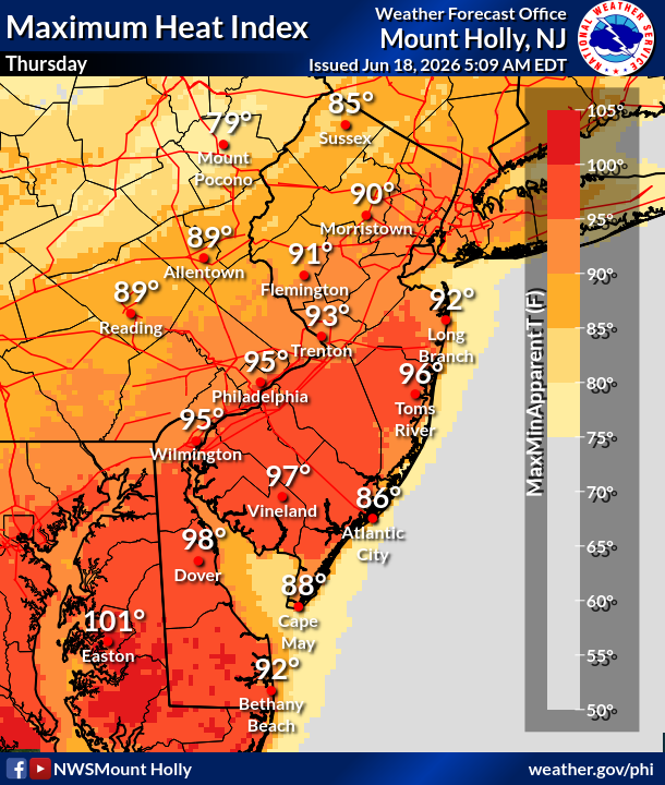
The storms will slightly mitigate another brutal day in the area, with highs in the low 90s and a heat index rising to 95, forecasters said.
The storm will also bring with it some rain, with up to a tenth of an inch falling around the area and the potential for significantly more where localized thunderstorms hit.
Find out what's happening in Across Pennsylvaniafor free with the latest updates from Patch.
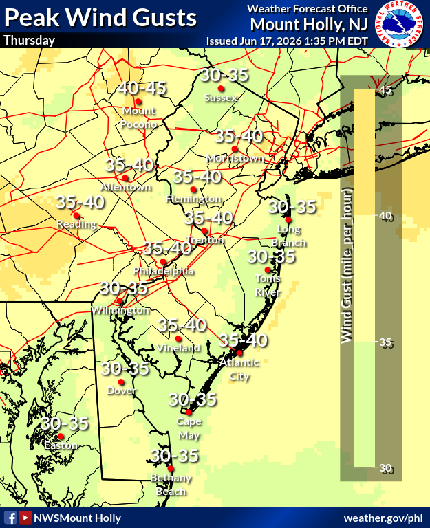
Winds are the primary threat to cause damage from the storm, with gusts ranging from 35 to 40 miles per hour expected around the Philadelphia area, forecasters said.
Sporadic power outages are possible, Accuweather warned.
"As a cold front pushes into the Northeast Thursday, winds will be unusually strong for June, even without thunderstorms, and capable of breaking tree limbs and sending unsecured objects in the yards or for trash collection sailing through neighborhoods," Accuweather added.
Storms will clear for the long Juneteenth holiday weekend, with mostly sunny skies anticipated until another round of storms threatens on Sunday night and Monday morning.
Here's the full forecast for the coming week, according to the National Weather Service:
Thursday
A slight chance of showers, then a chance of showers and thunderstorms after 2 p.m. Partly sunny, with a high near 92. Breezy, with a west wind 15 to 20 mph, with gusts as high as 35 mph. Chance of precipitation is 40 percent. New rainfall amounts of less than a tenth of an inch, except higher amounts possible in thunderstorms.
Thursday Night
Increasing clouds, with a low around 69. West wind 10 to 15 mph.
Juneteenth
Mostly cloudy, then gradually becoming sunny, with a high near 85. West wind 5 to 10 mph.
Friday Night
Clear, with a low around 66. West wind 5 to 10 mph.
Saturday
Sunny, with a high near 84. West wind 10 to 15 mph.
Saturday Night
Mostly clear, with a low around 64.
Sunday
Mostly sunny, with a high near 86.
Sunday Night
A chance of showers after 2 a.m. Mostly cloudy, with a low around 67. Chance of precipitation is 50 percent.
Monday
Showers, with thunderstorms also possible after 2 p.m. High near 82. Chance of precipitation is 80 percent.
Monday Night
A chance of showers and thunderstorms before 8 p.m., then a chance of showers between 8 p.m. and 2 a.m. Mostly cloudy, with a low around 64. Chance of precipitation is 50 percent.
Tuesday
Mostly sunny, with a high near 83.
Tuesday Night
Mostly clear, with a low around 63.
Wednesday
Mostly sunny, with a high near 86.
Get more local news delivered straight to your inbox. Sign up for free Patch newsletters and alerts.