Weather
Bomb Cyclone Nears PA: What To Expect For Snow, Winds
As the region digs out from last weekend, another winter storm is approaching. Forecasters are still uncertain on its ultimate impact.

A powerful winter storm that is expected to develop into a bomb cyclone along the Atlantic coast this weekend could still impact the Philadelphia area, but forecasters remain very uncertain over its ultimate track.
However, confidence has increased from Wednesday on the Philly region receiving significant snowfall. The chance of 4 inches or more in much of the five-county area is now up to 42 percent, the National Weather Service said, up from around 10 to 20 percent on Wednesday.
Forecasters still qualify this as "low confidence," though they're confident the storm will arrive near the coast late Saturday night into early Sunday morning, potentially continuing into Sunday afternoon.
Find out what's happening in Across Pennsylvaniafor free with the latest updates from Patch.
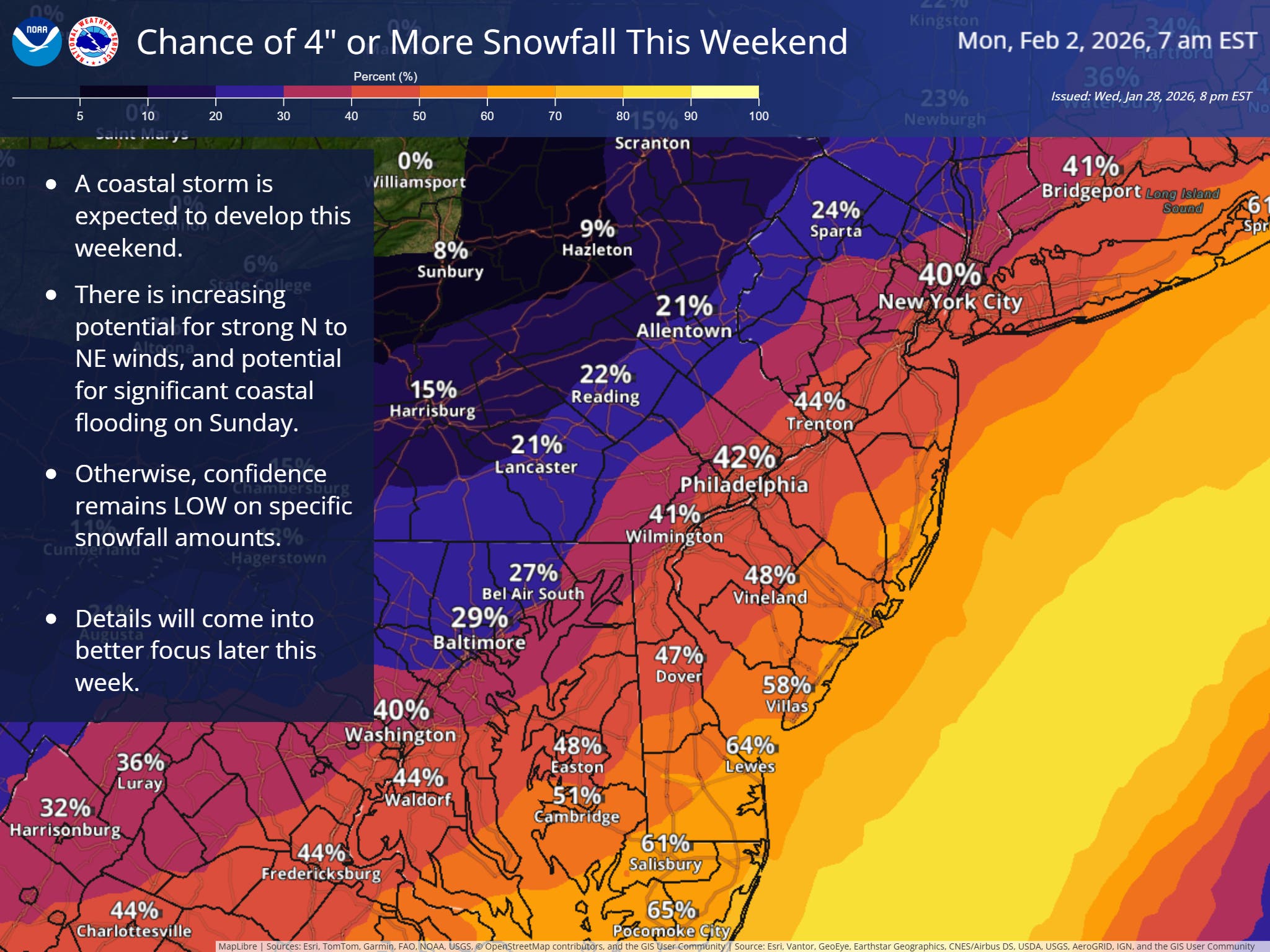
It appears to be variable enough that there could be three distinct possible outcomes.
"Snow accumulations could extend inland to the I-95 corridor and beyond, remain confined near the coast, or snow could stay mostly offshore," the National Weather Service's Mt. Holly, New Jersey branch shared.
Find out what's happening in Across Pennsylvaniafor free with the latest updates from Patch.
A bomb cyclone occurs when a storm front undergoes a rapid intensification due to a massive drop in atmospheric pressure.
There could be a very thin line between significant snow impacts and nothing, forecasters said.
"Instead of I-95 being the approximate dividing line between rain, ice and snow, it will be the boundary between accumulating snow and practically no snow at all," Accuweather said. "A dozen miles or less may determine the difference between non-accumulating flurries to snow-covered roads and slippery conditions."
More specific details, and greater confidence on exact impacts, are expected Friday.
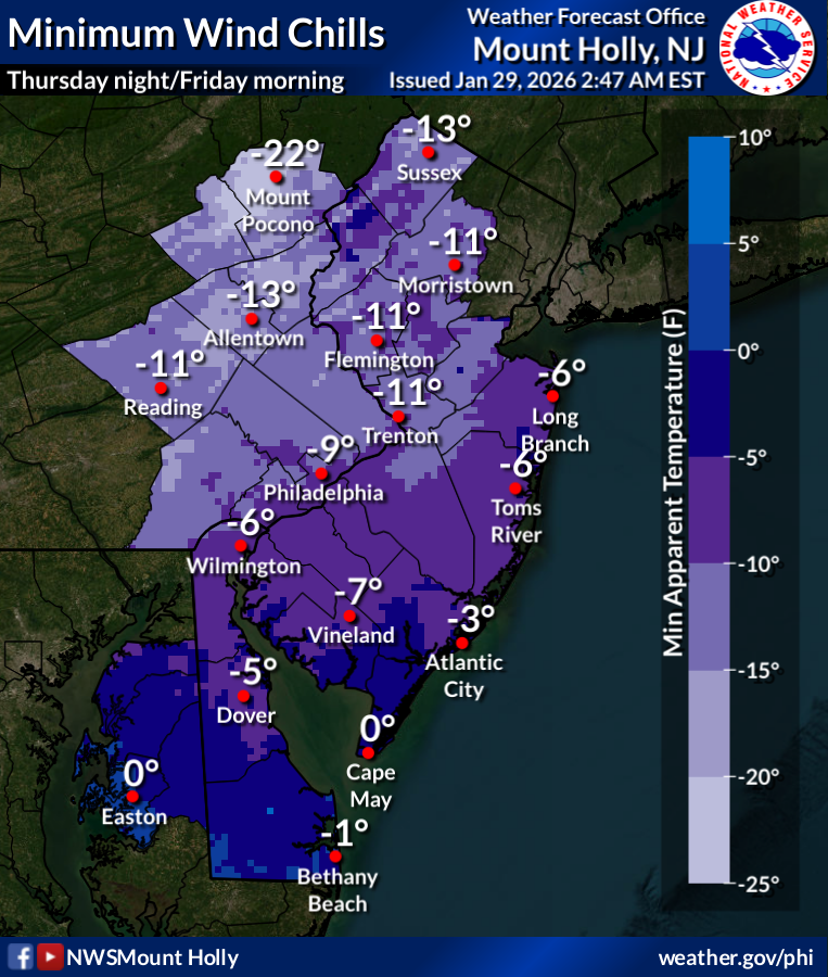
In the meantime, the region remains frigid, with low temperatures plummeting to 2 degrees Thursday night and wind chills dropping to negative 7. Wind chills will drop to negative 9 on Friday night, and the temperature when the storm arrives Saturday night is expected to be around 10 degrees.
Here is the full forecast for the coming week, according to the National Weather Service:
Thursday
Mostly sunny, with a high near 19. Wind chill values as low as -3. West wind 10 to 15 mph, with gusts as high as 25 mph.
Thursday Night
Mostly clear, with a low around 2. Wind chill values as low as -7. Northwest wind 5 to 10 mph.
Friday
Sunny, with a high near 17. Wind chill values as low as -11. West wind 5 to 10 mph, with gusts as high as 20 mph.
Friday Night
Partly cloudy, with a low around 1. Wind chill values as low as -9. West wind around 5 mph becoming calm.
Saturday
Partly sunny, with a high near 19. North wind around 5 mph.
Saturday Night
A chance of snow, mainly after 1 a.m. Mostly cloudy, with a low around 10. Chance of precipitation is 40 percent.
Sunday
A chance of snow before 1 p.m. Mostly cloudy, with a high near 23. Chance of precipitation is 30 percent.
Sunday Night
Mostly cloudy, with a low around 15.
Monday
Mostly sunny, with a high near 30.
Monday Night
Mostly clear, with a low around 16.
Tuesday
Mostly sunny, with a high near 32.
Tuesday Night
Partly cloudy, with a low around 18.
Wednesday
Mostly sunny, with a high near 30.
Get more local news delivered straight to your inbox. Sign up for free Patch newsletters and alerts.