Weather
Storms Target PA Before 'Heat Dome' Arrives: See Latest Forecast
A lingering weather phenomenon could bring severe conditions for days.

Some storms threaten the Philadelphia area this weekend ahead of a potentially brutal stretch of scorching weather described by meteorologists as a "heat dome."
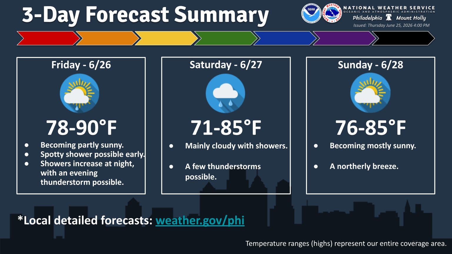
Storms will arrive in the late afternoon or early evening Friday, with a shower possible early. The period of more likely storms is between 9 p.m. and 2 a.m., with rain into the early morning hours.
Up to half an inch of rain could fall when all is said and done.
Find out what's happening in Across Pennsylvaniafor free with the latest updates from Patch.
Another round of storms loom throughout the day Saturday, with thunderstorms possibly starting after 11 a.m., and a chance again at 8 p.m. Rain could be intermittent throughout the day, with another half an inch potentially falling.
The more serious weather impacts may be from the looming heat dome, which could begin to impact the area from June 30 and linger through July 4, and could be a factor in plans for the long holiday weekend.
Find out what's happening in Across Pennsylvaniafor free with the latest updates from Patch.
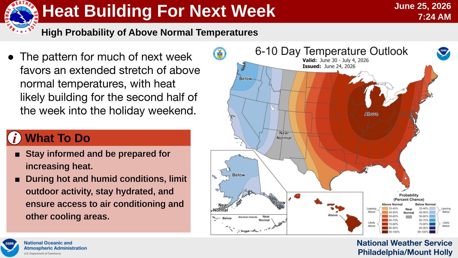
The front will set up over much of the eastern United States, Accuweather says. This pattern will bring extreme heat to the central and eastern states, with some possibly seeing temperatures of 100 degrees.
Accuweather meteorologist Dan Pydynowski described a heat dome as a "sprawling area of high pressure" that leads to long periods of heat and humidity.
“Heat domes can prevent clouds from forming, resulting in abundant sunshine that boosts temperatures, potentially toward record levels," Pydynowski added.
Here's the latest forecast for the Philadelphia area over the coming week., according to the National Weather Service:
Thursday Night
Partly cloudy, with a low around 67. South wind 5 to 10 mph.
Friday
Mostly cloudy, with a high near 90. South wind 5 to 10 mph becoming west in the afternoon.
Friday Night
A chance of showers before 9 p.m., then a chance of showers and thunderstorms between 9 p.m. and 2 a.m., then showers likely after 2 a.m. Areas of fog. Otherwise, mostly cloudy, with a low around 69. West wind around 5 mph becoming calm in the evening. Chance of precipitation is 60 percent. New rainfall amounts between a quarter and half of an inch possible.
Saturday
Showers, with thunderstorms also possible after 11 a.m. Areas of fog. High near 79. East wind around 5 mph. Chance of precipitation is 90 percent. New rainfall amounts between a quarter and half of an inch possible.
Saturday Night
Showers likely and possibly a thunderstorm before 8 p.m., then a chance of showers and thunderstorms between 8 p.m. and 2 a.m., then a slight chance of showers after 2 a.m. Areas of fog. Otherwise, mostly cloudy, with a low around 67. North wind around 5 mph. Chance of precipitation is 60 percent. New rainfall amounts between a tenth and quarter of an inch, except higher amounts possible in thunderstorms.
Sunday
Mostly sunny, with a high near 85.
Sunday Night
Mostly clear, with a low around 66.
Monday
Sunny, with a high near 89.
Monday Night
Partly cloudy, with a low around 67.
Tuesday
Mostly sunny, with a high near 92.
Tuesday Night
Partly cloudy, with a low around 71.
Wednesday
Mostly sunny, with a high near 93.
Wednesday Night
Partly cloudy, with a low around 73.
Thursday
Mostly sunny, with a high near 95.
Get more local news delivered straight to your inbox. Sign up for free Patch newsletters and alerts.