Weather
Thunderstorms, Tornado Possible In Philly Area Storm Thursday: Latest Forecast
The forecast for this week's storm has been clarified as the front approaches.


While the first snowfall of the season will not fall in the Philadelphia area this week as originally expected, a storm is developing over the area Thursday will potentially significant impacts.
Rain will begin Thursday morning and intensify this afternoon, with thunderstorms and even a tornado possible, according to the latest updated forecast.
The heaviest rain will fall around midday. Up to half an inch of rain is expected, with greater amounts where thunderstorms hit.
Find out what's happening in Across Pennsylvaniafor free with the latest updates from Patch.
"As the system passes and strengthens, a few thunderstorms may reach severe limits this afternoon," the National Weather Service's Mt. Holly, New Jersey branch shared. "The main risk is damaging winds and large hail, but there is a non-zero risk of an isolated tornado."
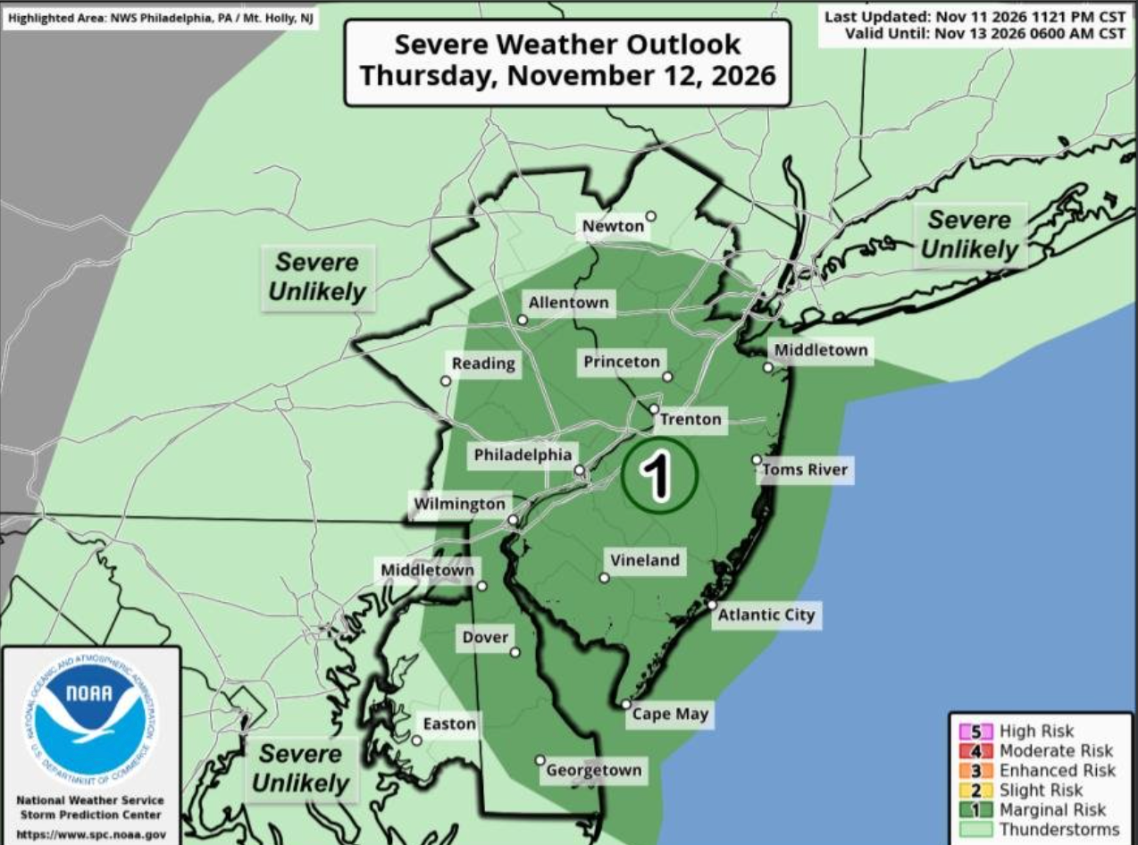
The National Weather Service has put the area in the level 1, "marginal risk" category for the storm.
Find out what's happening in Across Pennsylvaniafor free with the latest updates from Patch.
The storms could cause flight delays and issues on roadways.
"The low pressure area near the ground will interact with a storm several miles above it, near the altitude where commercial jets fly," Accuweather said. "Periods of rain, low clouds and even thunderstorm activity could cause flight delays into Saturday morning, with timing varying by location. Aircraft deicing and fog could also cause delays at some inland airports at higher elevations."
Rain will slow down later in the day Thursday before picking up again Friday morning.
Some precipitation is possible into the evening Friday.
Snow is possible in the higher elevations of the Poconos, but is not expected elsewhere in eastern Pennsyvlania.
Here's the full forecast for the coming week, according to the National Weather Service:
Thursday
Showers and possibly a thunderstorm. High near 63. East wind 5 to 10 mph becoming north in the afternoon. Chance of precipitation is 90 percent. New rainfall amounts between a tenth and quarter of an inch, except higher amounts possible in thunderstorms.
Thursday Night
Showers likely, mainly after 4 a.m. Cloudy, with a low around 42. North wind 5 to 10 mph, with gusts as high as 20 mph. Chance of precipitation is 60 percent. New precipitation amounts of less than a tenth of an inch possible.
Friday
Rain, mainly before 1 p.m. High near 47. Northwest wind 10 to 15 mph. Chance of precipitation is 100 percent. New precipitation amounts between a tenth and quarter of an inch possible.
Friday Night
A chance of rain, mainly after 1 a.m. Mostly cloudy, with a low around 36. Northwest wind around 10 mph. Chance of precipitation is 30 percent. New precipitation amounts of less than a tenth of an inch possible.
Saturday
Partly sunny, with a high near 48. Northwest wind around 10 mph, with gusts as high as 20 mph.
Saturday Night
Partly cloudy, with a low around 35.
Sunday
Mostly sunny, with a high near 51.
Sunday Night
Partly cloudy, with a low around 36.
Monday
Sunny, with a high near 52.
Monday Night
Mostly clear, with a low around 33.
Tuesday
Sunny, with a high near 53.
Tuesday Night
Mostly clear, with a low around 33.
Wednesday
Sunny, with a high near 58.
Get more local news delivered straight to your inbox. Sign up for free Patch newsletters and alerts.