Weather
Prolonged SoCal Heat Wave 20 Degrees Above Normal Begins: Here’s When It Will Peak
Temperatures are expected to be dangerously hot across Southern California for about a week, according to forecasters.


An unusually long stretch of extreme heat is expected to begin Friday across Southern California, with temperatures expected to surge into the triple digits in some areas through Saturday and remain well above normal for much of next week.
The National Weather Service issued Extreme Heat Warnings beginning at 10 a.m. Friday and continuing through 8 p.m. Thursday for Orange County, the Inland Empire and much of Los Angeles and Orange counties.
The heat will build quickly Friday before reaching its peak over the weekend, according to the NWS.
Find out what's happening in Los Angelesfor free with the latest updates from Patch.
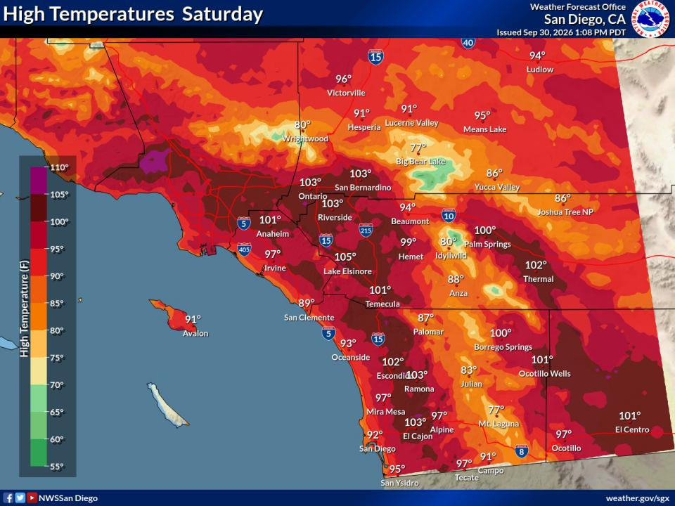
Friday temperatures are expected to run 10 to 15 degrees above normal across much of the region. Highs will reach the mid- to upper 80s across most coastal areas, with parts of the coast climbing into the lower to mid-90s. Valleys could reach anywhere from the upper 90s to 105 degrees.
Saturday is expected to be the hottest day of the next seven across much of SoCal, with another 2 to 4 degrees of warming in coastal and valley areas and localized increases of as much as 6 degrees.
Find out what's happening in Los Angelesfor free with the latest updates from Patch.
Temperatures could run 15 to 20 degrees above average on Saturday, with some coastal areas more than 25 degrees above normal, forecasters said.
Easterly Santa Ana winds could also gust from 35 to 45 mph Saturday, particularly in the San Diego County mountains and inland valleys, with isolated gusts reaching 55 mph.
Temperatures should ease slightly Sunday, but the cooldown will be limited.
Forecasted High Temperatures
| City | Friday | Saturday | Sunday |
|---|---|---|---|
| Van Nuys | 103 | 104 | 105 |
| Murrieta | 100 | 99 | 101 |
| Irwindale | 100 | 101 | 101 |
| Los Angeles | 95 | 99 | 99 |
| Santa Ana | 97 | 101 | 99 |
| Laguna Hills | 99 | 102 | 99 |
| Burbank | 93 | 98 | 99 |
| Palm Desert | 99 | 97 | 98 |
| San Diego | 98 | 100 | 95 |
| Long Beach | 90 | 94 | 95 |
| LAX | 88 | 93 | 94 |
| Banning | 94 | 93 | 93 |
| Santa Monica | 88 | 92 | 93 |
| Newport Beach | 88 | 95 | 91 |
Record-Breaking Temperatures Are Possible
Los Angeles could approach the city's record high for Monday, which is 101 degrees set in 1971. The historical average high for early October is around 80 degrees, according to AccuWeather.
It's expected to remain unusually hot across SoCal well beyond the weekend.
AccuWeather forecasts highs above 90 degrees in much of Los Angeles County continuing through at least the middle of next week, while Palm Springs could remain near or above 100 degrees through next week.
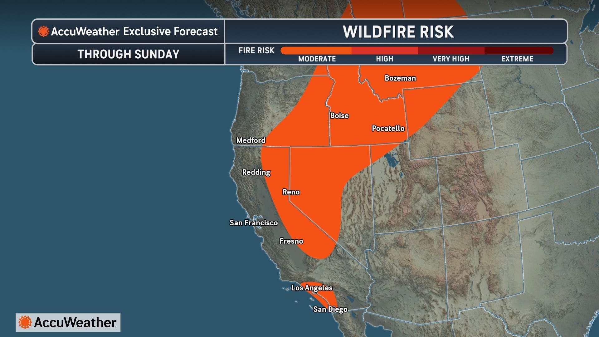
Coastal Orange County highs are expected to range from the mid-80s to around 90 near the beaches and reach the lower to mid-90s farther inland. Inland Orange County could reach the mid-90s to near 100, with overnight lows mostly in the lower to mid-70s.
Warm nights will compound the prolonged daytime heat. Overnight lows across coastal and valley areas are expected to remain mostly in the 70s from Saturday through Tuesday, according to the NWS.
"There will be little relief from the heat overnight, with lows expected to remain in the 70s across the Los Angeles basin into early next week. The warm nights can lead to uncomfortable sleeping conditions, especially for those without air conditioning," AccuWeather Meteorologist Lauren Bader said.
The length of the heat wave is a major concern for forecasters.
"Even though this heat wave will not likely produce record heat it will still be very dangerous due to the prolonged duration of the event," the National Weather Service said. "The relentless heat will have a hazardous wearing down effect on people, (especially) the very young and old."
Humidity Expected, Chance Of Thunderstorms
Humidity could begin increasing Monday through Wednesday as moisture associated with Hurricane Rachel moves into the region. That will bring a 5% to 15% chance of afternoon showers or thunderstorms in the mountains, according to the NWS.
Some cooling could begin reaching Southern California around Friday, Oct. 9. Longer-range forecasts indicate broader improvement could begin that weekend, according to the NWS.
City News Service contributed to this report.
Get more local news delivered straight to your inbox. Sign up for free Patch newsletters and alerts.