Weather
3 Storms Barreling Toward SoCal To Unleash Rain And Flooding
Southern California weather conditions are about to take a dramatic turn as cool temperatures and rain return to the region.


ORANGE COUNTY, CA — Unseasonably warm weather across Southern California is expected to giveway this weekend to below-normal temperatures as three low-pressure storm systems hit the region back-to-back-to-back.
According to the National Weather Service, the likelihood of widespread rain across Southern California exceeds 90 percent Friday, when the first system is expected to move in. However, it's not clear how much rain will fall.
The brunt of the storm trio is expected to remain over the Pacific Ocean. Still, National Weather Service forecasters warned that residents should prepare for a drop in temperatures, downpours and hazardous surf conditions starting as early as Thursday night and lasting through next week.
Find out what's happening in Orange Countyfor free with the latest updates from Patch.
The dramatic cooling trend follows a period of sweltering heat across Southern California, where temperatures hovered in the upper 80s to low-90s. By Monday, much of Southern California will top out in the upper 60s from the coast to the Inland Empire.
According to National Weather Service Meteorologist Casey Oswant, the chance of rain across Southern California begins as early as Thursday night or late Friday, with periods of light to moderate showers extending into Saturday morning before tapering off for Sunday.
Find out what's happening in Orange Countyfor free with the latest updates from Patch.
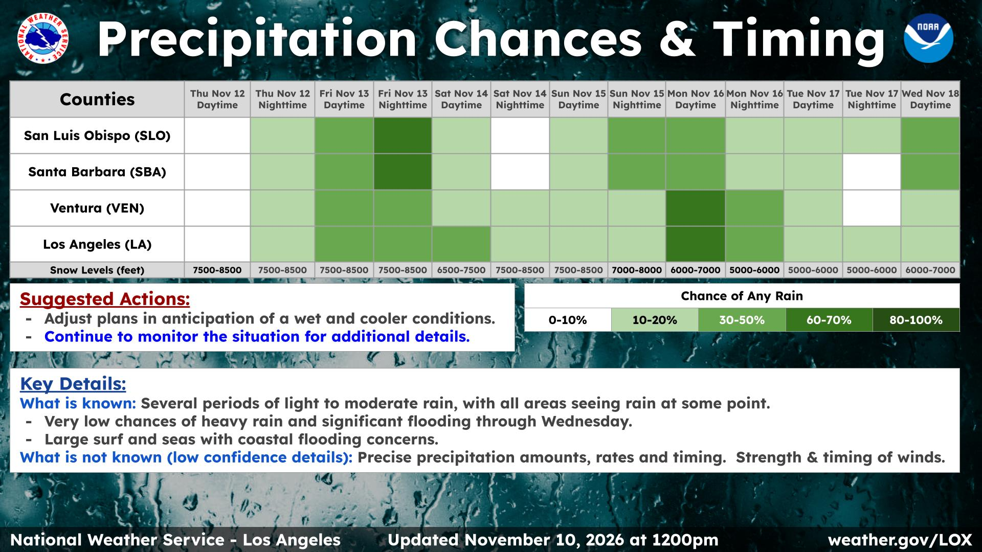
SoCal mountain and desert communities can also expect increased wind gusts over the weekend, Oswant said.
Snow levels are also expected to remain relatively high at above 8,000 feet, weather officials said.
By Monday, a second, faster-moving system is expected to arrive.
"It does look pretty likely that we will see additional rain sometime Monday and Tuesday. There is still uncertainty in the details, but a lot of our guidance is showing rain," Oswant told Patch.
A third possible system may hit by next Wednesday or Thursday, the National Weather Service reported.
Storm activity also means increased swells and possible beach erosion for already-battered Southern California coastal communities.
Coastal areas face immediate coastal flooding and high surf advisories due to morning high tides projected to peak between 7.0 and 7.4 feet, according to the service.
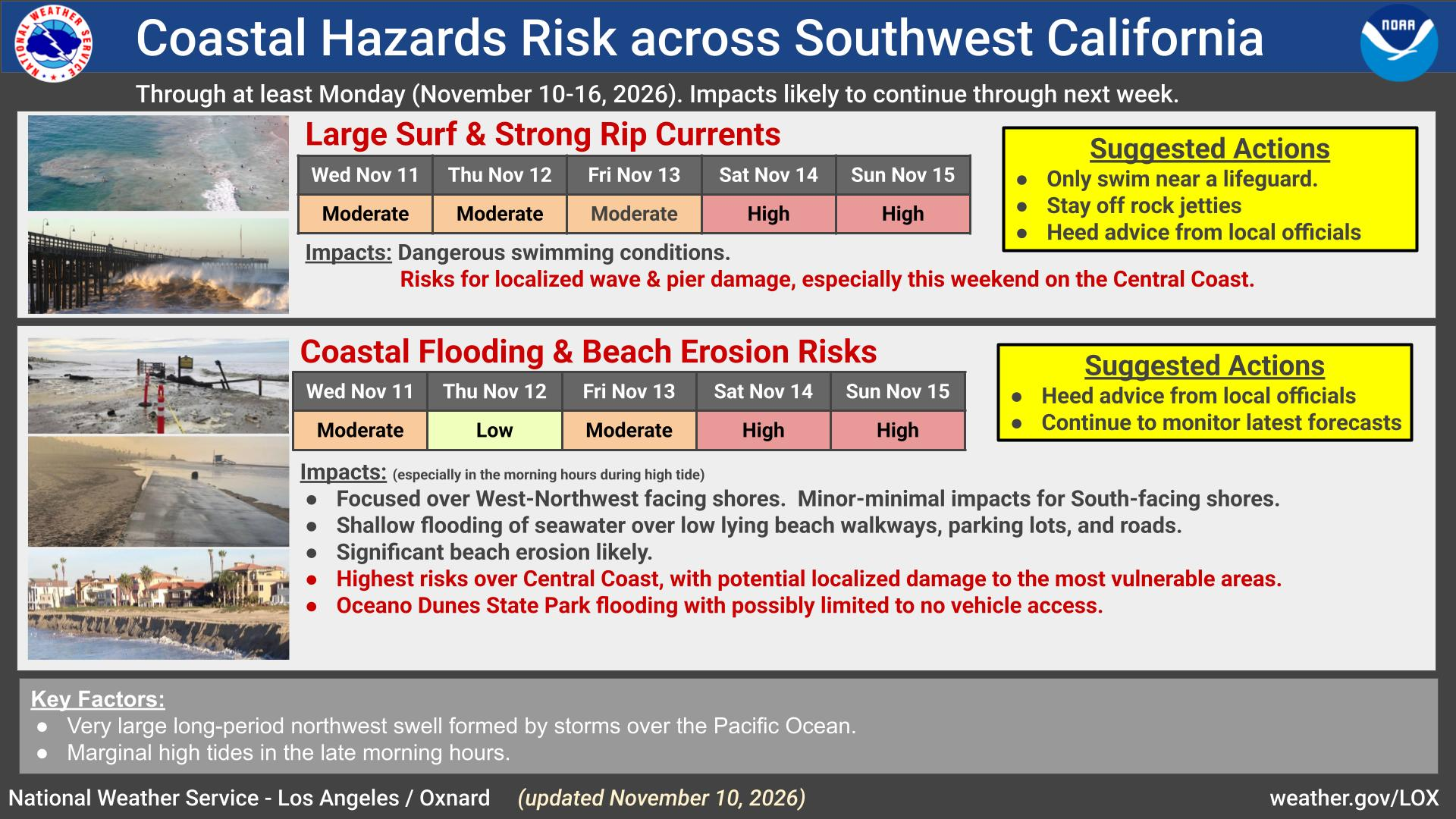
A beach hazards statement is already in place for Los Angeles and Ventura counties through Monday, though Oswant warned that many beachside communities across SoCal may see higher-than-average tides starting this week.
The high surf will likely linger into early next week, threatening beach parking lots, low-lying walkways, residential neighborhoods and coastal erosion.
The highest risks for flooding and beach erosion will happen on Saturday and Sunday, according to the service.
Residents were urged to steer clear of the waves due to the increased risk of drowning due to rip currents, which can drag swimmers out to sea.
Get more local news delivered straight to your inbox. Sign up for free Patch newsletters and alerts.