Weather
Hazardous Weather Outlook Issued For Southern CT: Here's What To Know
The National Weather Service has issued a hazardous weather outlook for all of southern Connecticut. Here's what you need to know.

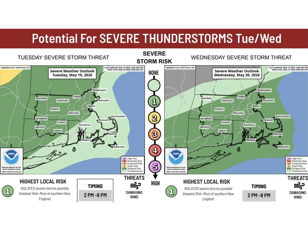
A hazardous weather outlook has been issued for southern Connecticut due to the potential for strong thunderstorms on Wednesday.
“Thunderstorm development is expected Wednesday with a cold frontal passage,” the National Weather Service said. “A few of the storms could be severe, with damaging winds the main threat.”
The National Weather Service anticipates thunderstorms are most likely to impact the region after 2 p.m. on Wednesday.
Find out what's happening in Across Connecticutfor free with the latest updates from Patch.
Meanwhile, an air quality alert is in effect Tuesday until 11 p.m.
The Connecticut Department of Energy and Environmental Protection has issued an Air Quality Action Day for Fairfield, New Haven, and Middlesex counties. Ground level ozone may approach or exceed unhealthy standards, according to the department.
Find out what's happening in Across Connecticutfor free with the latest updates from Patch.
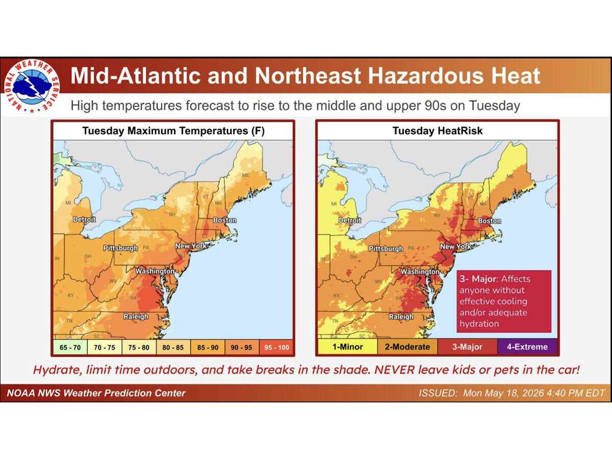
WFSB is calling both Tuesday and Wednesday a “First Alert Weather Day.”
While inland Connecticut is expected to reach the mid-90s, southern counties will be slightly cooler, with temperatures in the upper 80s today, according to the National Weather Service.
“Along the shoreline, the Bridgeport record of 89 was set in 2017, this one may be close! Regardless, it will be the hottest day of the year so far,” WFSB reports.
WFSB also predicts the potential for thunderstorms on Wednesday.
“As an approaching cold front moves closer during the afternoon it will likely spark off scattered storms, some of which could be strong or even severe,” WFSB reports. “The greatest concern in those that develop: heavy rain, a gusty wind, and frequent lightning.”
Thursday and Friday are expected to be cooler and more pleasant, according to the National Weather Service, which is predicting daytime highs in the upper 60s to low 70s. Showers are likely for Saturday and Sunday, with cloudy skies on Memorial Day.
“Saturday has been trending wetter and wetter, and it looks like we’ll see some shower activity for at least part of the day. There’s also the potential for some of these showers to stick around into Sunday, but current model guidance suggests we dry out by Memorial Day itself,” WFSB reports.
Read More:
1 Dead, Child Injured As Accused Drunk Driver Crashes Into Motorcycle, School Bus: PD: CT News
Pedestrian Struck On Highway / Motorcyclist Killed In Crash / Duck Family Rescued At Stop & Shop / Teacher Receives National Award & More…>>>Read More.
Here are the forecast details for southern Connecticut via the National Weather Service:
Today: Sunny, with a high near 88. South wind 7 to 11 mph.
Tonight: Partly cloudy, with a low around 68. Southwest wind around 6 mph.
Wednesday: Showers and possibly a thunderstorm after 2 p.m. High near 89. Southwest wind 6 to 11 mph. Chance of precipitation is 90%. New rainfall amounts of less than a tenth of an inch, except higher amounts possible in thunderstorms.
Wednesday Night: Showers and possibly a thunderstorm before 8 p.m., then a chance of showers between 8 p.m. and 2 a.m. Low around 56. North wind 3 to 6 mph. Chance of precipitation is 80%.
Thursday: Partly sunny, with a high near 73. North wind 5 to 7 mph.
Thursday Night: Mostly cloudy, with a low around 51.
Friday: Partly sunny, with a high near 68.
Friday Night: Showers likely, mainly after 2 a.m. Mostly cloudy, with a low around 49. Chance of precipitation is 70%.
Saturday: Showers. High near 61. Chance of precipitation is 80%.
Saturday Night: Showers likely. Cloudy, with a low around 51. Chance of precipitation is 70%.
Sunday: Showers likely. Mostly cloudy, with a high near 67. Chance of precipitation is 60%.
Sunday Night: A 40 percent chance of showers. Mostly cloudy, with a low around 52.
Memorial Day: Mostly cloudy, with a high near 72.
Get more local news delivered straight to your inbox. Sign up for free Patch newsletters and alerts.