Weather
Snow Accumulation Estimates Released For Friday In CT
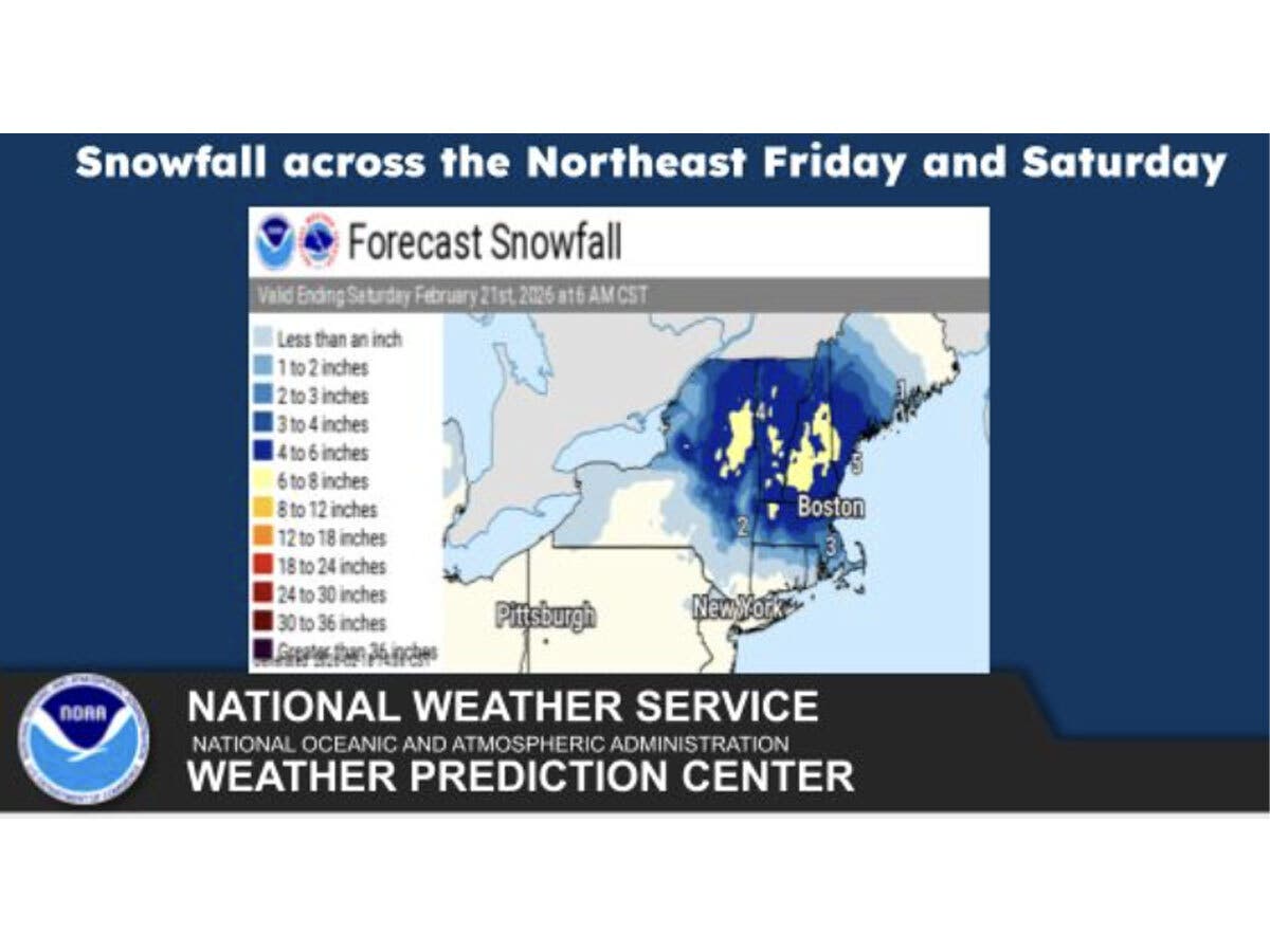
A strong nor'easter storm may also bring more snow to CT. Here are the new details on an active weather pattern.

UPDATE: The National Weather Service has issued a winter weather advisory for Hartford, Tolland and Windham counties from 10 a.m. Friday to 7 a.m. Saturday.
"Mixed precipitation expected. Total snow and sleet accumulations of a coating to 3 inches and ice accumulations up to around two tenths of an inch...Plan on slippery road conditions. The hazardous conditions could impact the Friday evening commute.
Original story: Snow, rain and a wintry mix are in the forecast for Friday in Connecticut, and meteorologists are closely monitoring the possibility of a late weekend snowstorm.
Find out what's happening in Across Connecticutfor free with the latest updates from Patch.
WFSB is calling Friday a “First Alert Weather Day,” and it anticipates the precipitation will impact both the morning and evening commutes.
“What begins as snow will transition to an icy mix and rain,” WFSB reports.
Find out what's happening in Across Connecticutfor free with the latest updates from Patch.
It predicts interior Connecticut could see between one and three inches of snowfall on Friday.
“During the afternoon, a period of freezing drizzle could lead to a glaze of ice,” WFSB predicts. “Then toward and after the evening commute a final round of precipitation sweeps through, coming in the form of scattered snow showers.”
WTNH reports wet snow and mixed precipitation will arrive on Friday around the time of the morning commute. School schedules could be impacted, especially for inland Connecticut, according to the station.
WTNH is forecasting the snow will change to rain quickly in southern Connecticut, while mixed precipitation will last longer in northern areas.
WTNH predicts a “coating” for southern Connecticut on Friday, with northern Connecticut getting between one and two inches of snow, followed by an “icy mix on top.”
Snow showers will linger into Friday night and Saturday, according to WTNH.
Monitoring a large storm
Meteorologists are continuing to track a large storm which could impact the state late Sunday into Monday. As of mid-day Thursday, forecasters said it could either be a miss for Connecticut or could bring “heavy snow.”
“The biggest concern is a large storm moving off the east coast Sunday night and undergoing Bombogenesis in the ocean south and east of Connecticut on Monday!” WTNH reports. “This will bring some snow and also windy conditions to our state. If it gets closer, we could be in the heavy snow bands.”
The Weather Channel as of Thursday reported the chances are increasing that a “nor'easter/coastal storm will develop and impact the East Coast this weekend.”
“The forecast is still very uncertain as the exact track will determine where the heaviest snow will fall,” the Weather Channel reported. “At this time there is a chance for snow along the I-95 corridor Sunday into Monday.”
WFSB as of Thursday said it is still closely watching the potential impacts from the coastal storm for Monday.
“While longer range model guidance have it developing, what is uncertain is the track it takes relative to CT,” WFSB reports.
Read More:
- Mass Layoffs Announced At Major Business
- Home Invasion Investigated; 2 Schools Closed
- Town Votes 8-1 To Shut Down License Plate Reader Cameras
Here are the forecast details for northern Connecticut via the National Weather Service:
Today: Partly sunny, with a high near 40. Calm wind.
Tonight: Mostly cloudy, with a low around 27. Calm wind.
Friday: A chance of snow before 11 a.m., then rain, possibly mixed with snow between 11 a.m. and 3 p.m., then rain after 3 p.m. High near 37. Calm wind becoming northeast 5 to 7 mph in the afternoon. Chance of precipitation is 100%. New snow accumulation of less than a half inch possible.
Friday Night: Rain and snow, becoming all snow after midnight. Low around 29. North wind 3 to 5 mph. Chance of precipitation is 90%. New snow accumulation of 1 to 2 inches possible.
Saturday: A chance of snow. Cloudy, with a high near 39. Calm wind becoming northeast around 5 mph in the afternoon. Chance of precipitation is 40%. New snow accumulation of less than a half inch possible.
Saturday Night: A chance of snow, mainly before midnight. Mostly cloudy, with a low around 21. Light northeast wind. Chance of precipitation is 30%. Little or no snow accumulation expected.
Sunday: A chance of rain after 3 p.m. Partly sunny, with a high near 37. Northeast wind 5 to 8 mph. Chance of precipitation is 30%.
Sunday Night: A chance of snow. Mostly cloudy, with a low around 25. North wind 7 to 10 mph, with gusts as high as 20 mph. Chance of precipitation is 40%.
Monday: A chance of snow. Mostly cloudy, with a high near 34. North wind 11 to 14 mph. Chance of precipitation is 40%.
Here are the forecast details for southern Connecticut via the National Weather Service:
Today: Cloudy, with a high near 39. East wind 7 to 9 mph.
Tonight: A 40 percent chance of snow after 4 a.m. Mostly cloudy, with a low around 30. East wind 3 to 7 mph.
Friday: Rain and snow, becoming all rain after 10 a.m. High near 38. Wind chill values between 25 and 30. East wind 8 to 13 mph. Chance of precipitation is 100%. New snow accumulation of less than a half inch possible.
Friday Night: A chance of rain before 4 a.m., then a slight chance of rain and snow. Cloudy, with a low around 30. Northeast wind 5 to 8 mph becoming light and variable after midnight. Chance of precipitation is 50%.
Saturday: A slight chance of snow before 10 a.m., then a chance of rain and snow between 10 a.m. and 4 p.m., then a chance of snow after 4 p.m. Mostly cloudy, with a high near 41. Light and variable wind becoming northeast around 6 mph in the afternoon. Chance of precipitation is 30%.
Saturday Night: A 30 percent chance of snow before 1 a.m. Mostly cloudy, with a low around 26.
Sunday: A 40 percent chance of snow after 1 p.m. Mostly cloudy, with a high near 37.
Sunday Night: A 50 percent chance of snow. Mostly cloudy, with a low around 27.
Monday: A 30 percent chance of snow before 1 p.m. Mostly cloudy, with a high near 36.
Get more local news delivered straight to your inbox. Sign up for free Patch newsletters and alerts.