Weather
Snow Accumulation Estimates Released For Next Storm In CT
After a break, snow is again in the forecast for Connecticut this week. Find out the latest timeline.

Connecticut will get a brief respite from wintry weather today, but more snow is predicted to fall tomorrow, according to meteorologists.
While today will be dry and sunny for snow removal efforts, the National Weather Service reports “much lighter snowfall” is expected Wednesday due to a clipper system.
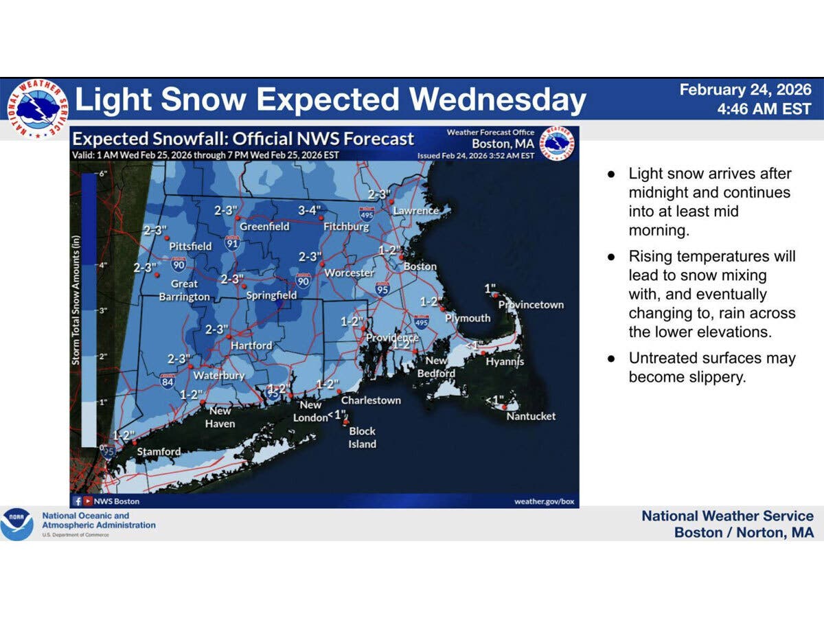
Snow will begin in the pre-dawn hours Wednesday and last into at least mid-morning, according to the National Weather Service. The snow is expected to be a wintry mix and then change over to rain in lower elevation areas.
Find out what's happening in Across Connecticutfor free with the latest updates from Patch.
The National Weather Service predicts this next system on Wednesday will bring between one and two inches of new snow along the shore, and two to three inches inland.
WFSB is calling Wednesday a “First Alert Weather Day,” due to the snow.
Find out what's happening in Across Connecticutfor free with the latest updates from Patch.
WFSB’s meteorologists predict the state will get between one and three inches of snow, which could impact the Wednesday morning commute.
According to WTNH, the Wednesday morning snow will arrive between 4 a.m. to 6 a.m., making for a “slick a.m. commute,” potentially impacting school schedules.
WTNH meteorologists predict the snow will end between 10 a.m. and noon, with a fresh snow total of between one and three inches.
According to WFSB, there is a chance for a wintry mix Thursday night, then Friday and the weekend look to be dry and milder.
Read More:
- Massive Brawl Reported At Mall
- Teen Critically Injured In Shooting: Police
- Pedestrian Struck By Car Boards Bus To Another Town, Later Dies: Police
Here are the forecast details for northern Connecticut via the National Weather Service:
Today: Mostly sunny, with a high near 27. Northwest wind around 11 mph, with gusts as high as 22 mph.
Tonight: A chance of snow after 5 a.m. Increasing clouds, with a low around 9. Light and variable wind. Chance of precipitation is 30%. New snow accumulation of around an inch possible.
Wednesday: Rain and snow before noon, then a chance of rain between noon and 3 p.m. High near 39. South wind 6 to 10 mph, with gusts as high as 20 mph. Chance of precipitation is 100%. New snow accumulation of 1 to 3 inches possible.
Wednesday Night: Partly cloudy, with a low around 23. West wind 5 to 7 mph.
Thursday: A chance of snow, mainly after 3 p.m. Partly sunny, with a high near 39. West wind 3 to 6 mph. Chance of precipitation is 30%. New snow accumulation of less than a half inch possible.
Thursday Night: A chance of snow. Mostly cloudy, with a low around 20. Light north wind. Chance of precipitation is 50%. New snow accumulation of 1 to 2 inches possible.
Friday: Mostly sunny, with a high near 40. Light and variable wind becoming northwest around 6 mph in the morning.
Friday Night: Mostly clear, with a low around 21. South wind 3 to 5 mph.
Saturday: Mostly sunny, with a high near 45. South wind 6 to 9 mph.
Here are the forecast details for southern Connecticut via the National Weather Service:
Today: Increasing clouds, with a high near 30. Wind chill values between 15 and 20. Northwest wind 7 to 9 mph.
Tonight: Snow likely, mainly after 4 a.m. Increasing clouds, with a low around 17. West wind around 5 mph becoming calm. Chance of precipitation is 60%. New snow accumulation of around an inch possible.
Wednesday: Snow, mainly before 10 a.m. High near 39. Wind chill values between 25 and 35. Southwest wind 7 to 10 mph. Chance of precipitation is 80%. New snow accumulation of less than one inch possible.
Wednesday Night: Partly cloudy, with a low around 27. West wind around 6 mph.
Thursday: A 40 percent chance of snow after 1 p.m. Partly sunny, with a high near 39. West wind 3 to 6 mph.
Thursday Night: A 50 percent chance of snow. Mostly cloudy, with a low around 26.
Friday: Mostly sunny, with a high near 38.
Friday Night: Mostly clear, with a low around 25.
Saturday: Mostly sunny, with a high near 43.
Get more local news delivered straight to your inbox. Sign up for free Patch newsletters and alerts.