Weather
Timeline For Severe Thunderstorms Released For CT: Here's What To Know
Hail and damaging wind gusts are possible, according to meteorologists.


Showers and possible strong to severe thunderstorms are in the forecast this afternoon and evening, according to meteorologists.
The National Weather Service reports any storms will be “isolated to scattered.”
The main threats will be “large hail and damaging wind gusts,” according to a hazardous weather outlook alert from the National Weather Service.
Find out what's happening in Across Connecticutfor free with the latest updates from Patch.
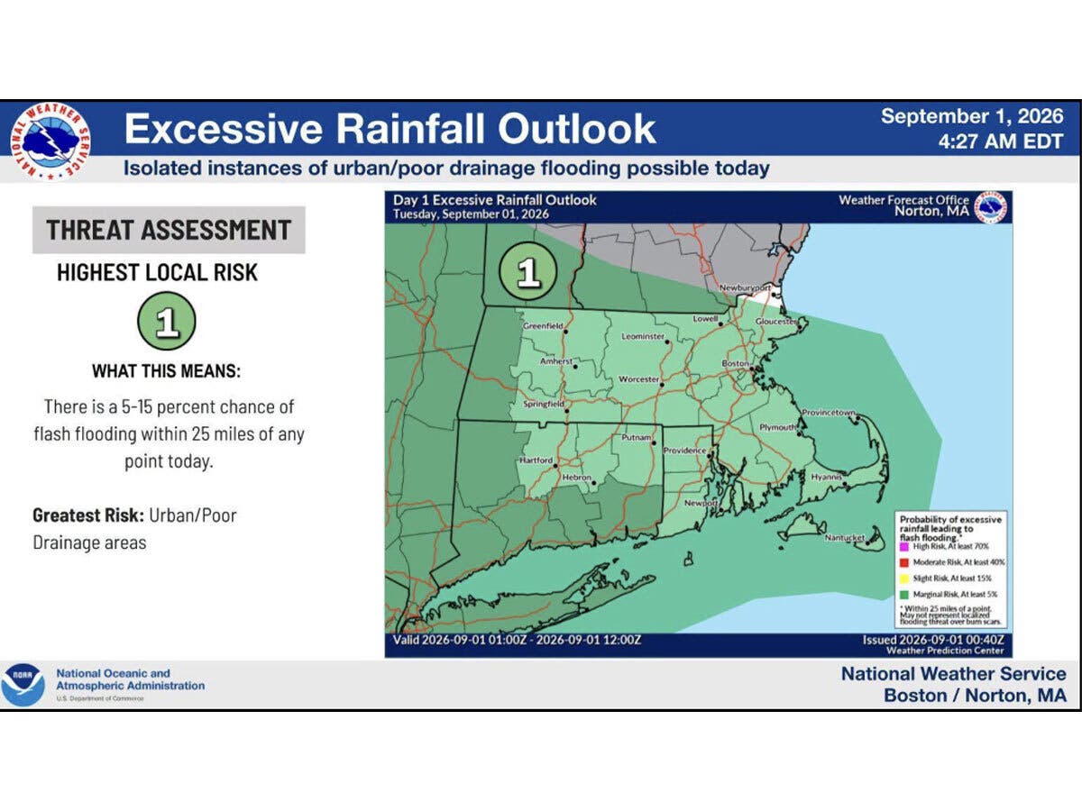
Storms could bring periods of heavy rainfall, which could result in isolated flash flooding, particularly in urban and poor drainage areas, forecasters said.
The National Weather Service described the risk of flash flooding as “marginal,” or Level 1 out of 4.
Find out what's happening in Across Connecticutfor free with the latest updates from Patch.
WTNH reports today will be an active weather day due to a “stationary weather front draped over Connecticut.”
“Waves of rain and developing thunderstorms will come through into this evening. Pay attention to any storms during the afternoon as they could be severe,” WTNH reports.
WTNH predicts damaging winds, flooding rain, hail and “even some rotation” will be possible.
The National Weather Service cautions, “An isolated tornado cannot be ruled out.”
WFSB is calling today a “First Alert Weather Day” due to rounds of rain and storms, and damaging wind potential.
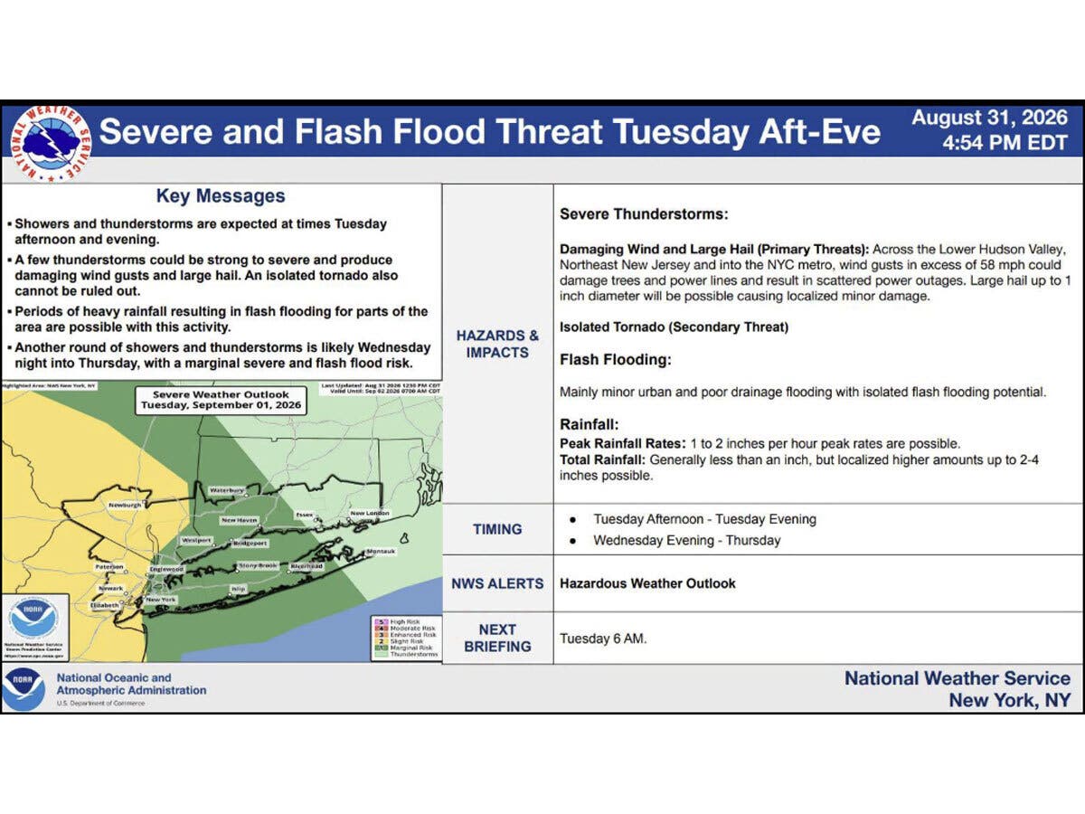
Another round of showers and thunderstorms is likely Wednesday night into Thursday, according to the National Weather Service.
The unsettled weather pattern is expected to clear out later in the workweek, with a sunny and dry forecast for Friday, and highs in the low 80s.
Read More:
- Prominent Pizzeria Opening 2 New Locations, Including A First-Of-Its-Kind Restaurant
- Woman, 32, Accused Of Stalking Teen She Met In Theater Group: Warrant
- Brawl Leads To 4 Arrests, Multiple Injuries: PD
Here are the forecast details for northern Connecticut via the National Weather Service:
Today: Showers likely and possibly a thunderstorm before 2 p.m., then a chance of showers and thunderstorms after 2 p.m. Some of the storms could produce heavy rainfall. Patchy fog before 3 p.m. Otherwise, cloudy, with a high near 74. East wind 3 to 6 mph. Chance of precipitation is 70%. New rainfall amounts between a quarter and half of an inch possible.
Tonight: A chance of showers and thunderstorms. Patchy fog after 8 p.m. Otherwise, cloudy, with a low around 61. Northeast wind 6 to 8 mph. Chance of precipitation is 40%. New precipitation amounts between a tenth and quarter of an inch, except higher amounts possible in thunderstorms.
Wednesday: Patchy fog before 9 a.m. Otherwise, mostly cloudy, with a high near 75. East wind around 7 mph.
Wednesday Night: Showers likely and possibly a thunderstorm, then showers after 2 a.m. Patchy fog after 2 a.m. Low around 63. Southeast wind 5 to 8 mph. Chance of precipitation is 80%. New rainfall amounts between a tenth and quarter of an inch, except higher amounts possible in thunderstorms.
Thursday: Showers before 11 a.m., then a chance of showers and thunderstorms between 11 a.m. and 2 p.m., then showers likely and possibly a thunderstorm after 2 p.m. High near 83. Southwest wind around 7 mph. Chance of precipitation is 80%.
Thursday Night: Showers likely and possibly a thunderstorm before 8 p.m. Partly cloudy, with a low around 63. Northwest wind 3 to 5 mph. Chance of precipitation is 60%.
Friday: Sunny, with a high near 82. Northwest wind 5 to 11 mph.
Here are the forecast details for southern Connecticut via the National Weather Service:
Today: Showers likely before 2 p.m., then a chance of showers and thunderstorms between 2 p.m. and 5 p.m., then showers and possibly a thunderstorm after 5 p.m. Some of the storms could be severe. High near 77. Southeast wind 5 to 7 mph. Chance of precipitation is 80%. New rainfall amounts between a tenth and quarter of an inch, except higher amounts possible in thunderstorms.
Tonight: Showers and thunderstorms before 11 p.m., then a slight chance of showers between 11 p.m. and 2 a.m. Some of the storms could be severe. Low around 65. Northeast wind around 7 mph. Chance of precipitation is 80%. New precipitation amounts between a tenth and quarter of an inch, except higher amounts possible in thunderstorms.
Wednesday: A 20 percent chance of showers after 11 a.m. Mostly cloudy, with a high near 74. East wind around 10 mph.
Wednesday Night: A chance of showers, then showers likely and possibly a thunderstorm after 2 a.m. Mostly cloudy, with a low around 66. Southeast wind 3 to 6 mph. Chance of precipitation is 70%. New rainfall amounts between a tenth and quarter of an inch, except higher amounts possible in thunderstorms.
Thursday: Showers likely, with thunderstorms also possible after 2 p.m. Mostly cloudy, with a high near 83. Southwest wind 5 to 9 mph. Chance of precipitation is 60%. New rainfall amounts between a tenth and quarter of an inch, except higher amounts possible in thunderstorms.
Thursday Night: Showers likely and possibly a thunderstorm before 8 p.m., then a chance of showers between 8 p.m. and 2 a.m. Mostly cloudy, with a low around 66. Chance of precipitation is 60%. New precipitation amounts between a tenth and quarter of an inch, except higher amounts possible in thunderstorms.
Friday: Sunny, with a high near 82.
Get more local news delivered straight to your inbox. Sign up for free Patch newsletters and alerts.