Weather
Potential Tropical Threat Tracked In Gulf: What This Means For FL
Forecasters are keeping an eye on the Gulf, where Invest 92-L, which could strengthen into a tropical depression or storm, has popped up.


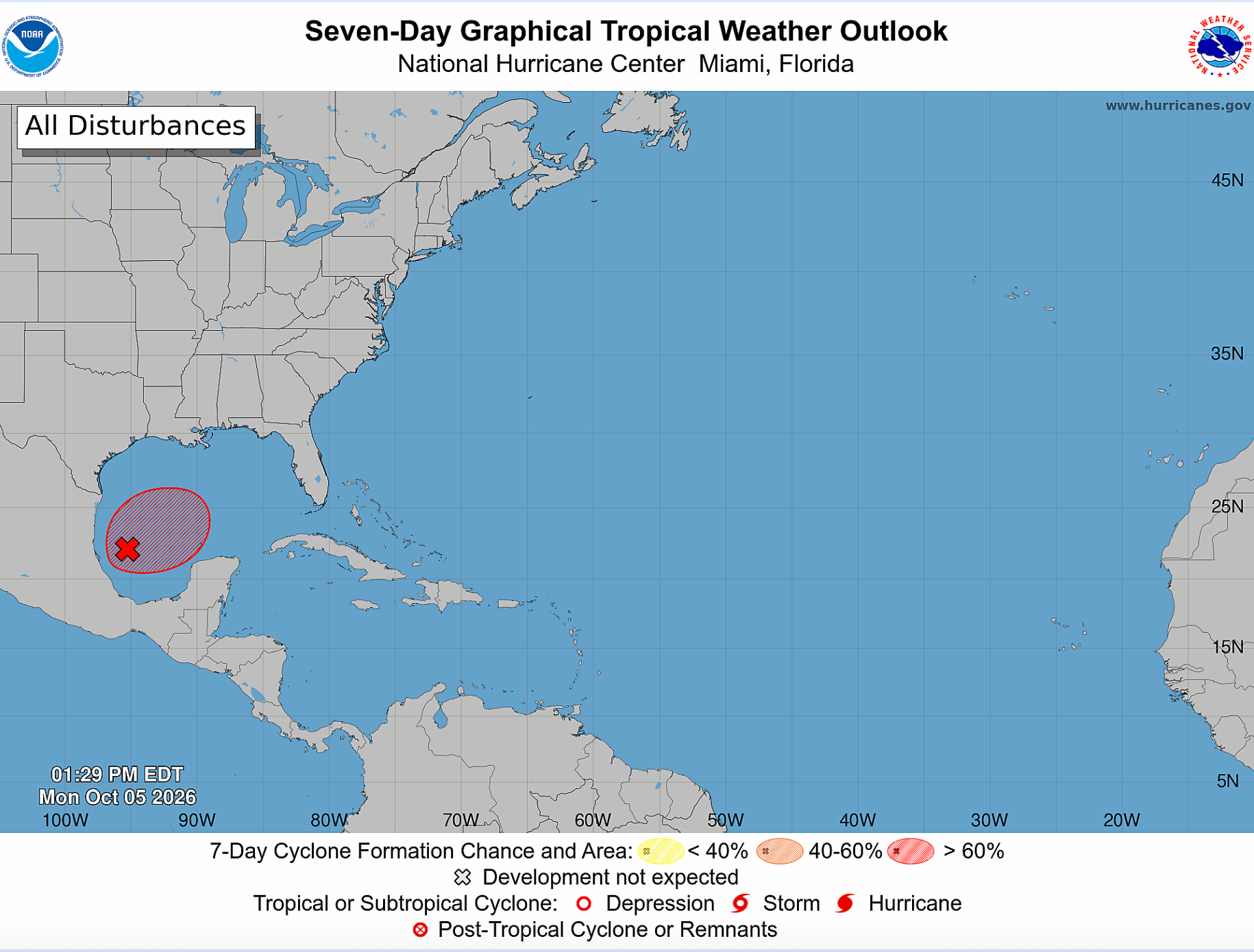
A potential tropical threat that popped up in the southwest Gulf over the weekend is being carefully watched by forecasters.
Invest 92-L, a trough of low pressure producing disorganized showers and thunderstorms on Monday afternoon, has a 60 percent chance of strengthening into a tropical depression or storm over the next two days and an 80 percent chance of strengthening within the week, the National Hurricane Center said.
“Although environmental conditions appear to be marginally conducive, gradual development is becoming more likely, and a tropical depression is expected to form during the middle portion of the week,” the NHC said. “This system is expected to drift eastward over the next couple of days, before it turns northward.”
Find out what's happening in Tampafor free with the latest updates from Patch.
If the system does develop, it could become Isaias, the ninth named storm of the 2026 Atlantic hurricane season. It’s been an unusually quiet season, largely thanks to a strong El Niño climate pattern, which typically increases vertical wind shear, making it more difficult for tropical systems to organize and strengthen.
Though it’s too early to tell where the Invest 92-L might land, NHC forecasters said areas in the northern Gulf Coast should keep an eye on the system.
Find out what's happening in Tampafor free with the latest updates from Patch.
Denis Phillips, chief meteorologist for Tampa Bay 28, said in a social media post that there’s a “solid chance” that a tropical depression or Isaias forms by the weekend.
“Most models keep a weak, ragged rainmaker impacting the Northern Gulf Coast early next week. (Rain with a name),” Phillips wrote in the post. “A few, including the Google Deep Earth, make it stronger in the latest runs. Until we actually have a system to track, models will be all over the place.”
This system is the type forecasters expect to see at this time of year, Fox 13’s Paul Dellegatto wrote in a social media post. “Stalled frontal boundaries — like the one currently draped over the Gulf — frequently serve as a focal point for tropical development. Sea surface temperatures are more than warm enough and upper-level conditions favor thunderstorms, though increasing wind shear along the northern Gulf will be a limiting factor.”
Dellegatto continued, “If a system manages to get going, steering currents would favor a generally northward track. Regardless of whether a named storm forms, one thing is certain: elevated rain chances and above-normal rainfall will persist through mid-October.”
Invest 92-L has popped up as the Southeast, including much of Florida, is expected to see “repeated rounds of flooding downpours through much of this week as tropical moisture interacts with a stalled front,” according to AccuWeather.
Between Monday and Wednesday morning, 1 to 2 inches of rain is expected from Cape Coral through Central Georgia and southern Alabama, across much of the Florida Panhandle, experts said.
From Panama City to Orlando, rain amounts will range from 2 to 4 inches, forecasters said. The heaviest rainfalls will be in northern Florida, with 4 to 8 inches expected. Rain could fall at rates of 1 to 3 inches per hour.
See Also:
- Atlantic Hurricane Season Could Make History After Remarkably Quiet Start
- 5 Things To Know About The 2026 Atlantic Hurricane Season
- Forecasters Continue To Lower Hurricane Season Predictions As Peak Season Nears
- NOAA Lowers 2026 Hurricane Forecast As Peak Season Nears
- 'Super El Niño' Could Form In Atlantic: What It Means For FL Hurricane Season
Get more local news delivered straight to your inbox. Sign up for free Patch newsletters and alerts.