Weather
2 Rounds Of Storms Possible In MD This Week: See Timeline, Forecast
Maryland could see two rounds of storms this week, with heat and humidity fueling the chances of severe weather.

Maryland could see two rounds of storms this week, with heat and humidity fueling the chances of severe weather that could bring damaging winds, heavy rain, and another chance of thunderstorms to the Baltimore region later this weekend.
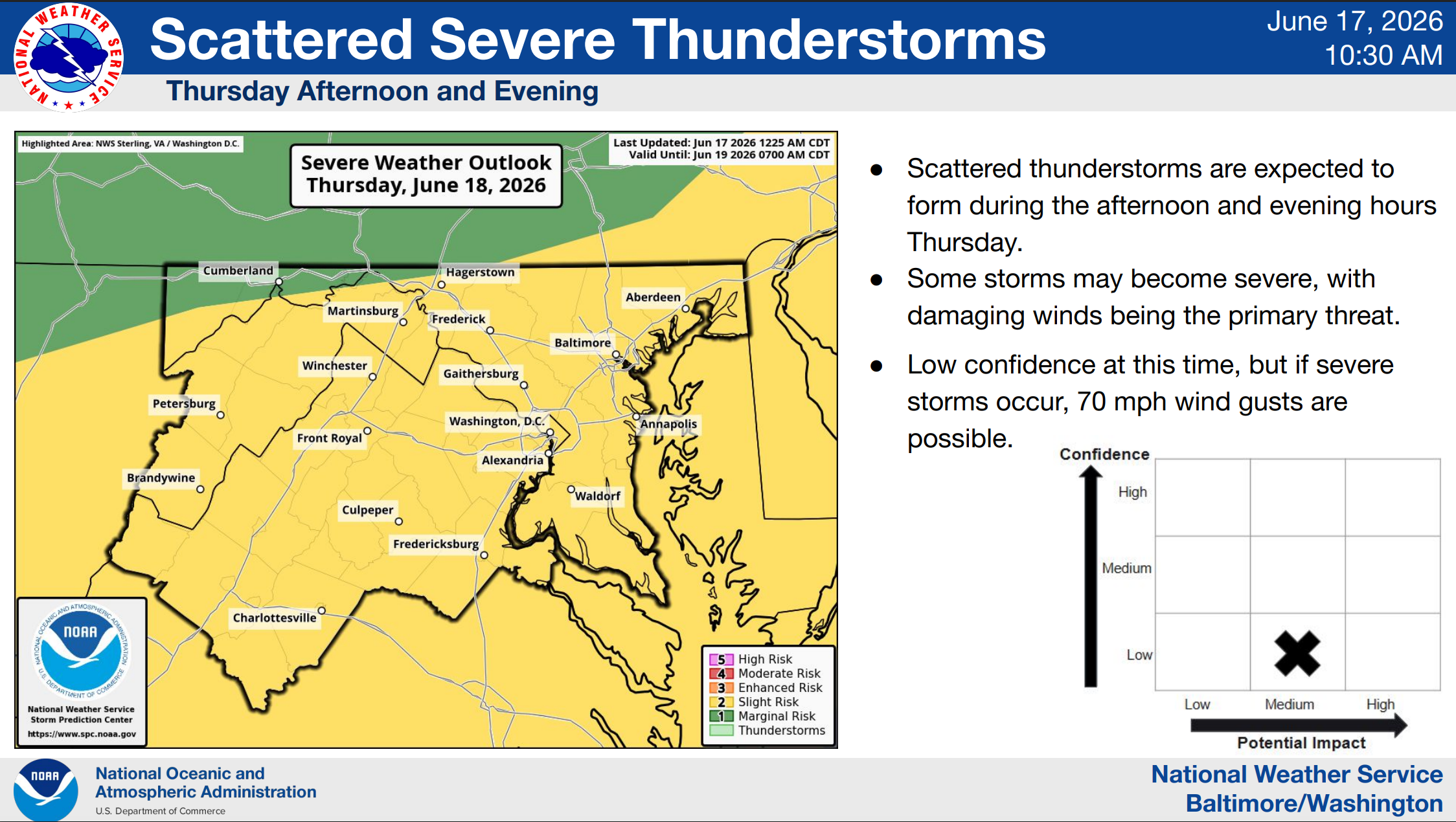
Following a calm, warm Wednesday, the first round of severe weather will arrive in the area on Thursday, according to the National Weather Service.
Extreme heat and humidity are also forecast for Thursday, with temperatures expected to reach the mid-90s and peak heat indices nearing 100 degrees, particularly along and east of the I-95 corridor.
Find out what's happening in Baltimorefor free with the latest updates from Patch.
That warm, humid air and increasing winds will make scattered strong to severe thunderstorms possible Thursday into Thursday evening.
The NWS Storm Prediction Center has the entire Baltimore region at a Slight Risk for severe thunderstorms on Thursday. Damaging winds will likely be the primary threat, with gusts up to 70 mph possible. Outside of thunderstorms, strong wind gusts may result in downed trees and power outages, especially at higher elevations.
Find out what's happening in Baltimorefor free with the latest updates from Patch.
A chance of showers will linger into Friday morning before skies clear and temperatures reach the mid- to upper 80s. Saturday will also be sunny, with a high near 86 degrees.
Meanwhile, forecasters are watching the potential for a strong area of low pressure to move across the region sometime between late Sunday and Monday.
According to the National Weather Service, the system could produce heavy rainfall and even a few thunderstorms; however, confidence in timing is "very low," forecasters said.
"Overall, it will be less hot and humid compared to some of the recent events, so any threat for strong to severe storms will
be more conditional," the National Weather Service wrote.
Here is the detailed forecast for the Baltimore region:
Wednesday: Mostly sunny, with a high near 88. Southwest wind around 7 mph.
Wednesday Night: Partly cloudy, with a low around 71. South wind around 7 mph.
Thursday: A slight chance of showers and thunderstorms before 3pm, then a chance of showers and thunderstorms after 4pm. Partly sunny, with a high near 95. Heat index values as high as 100. Southwest wind 13 to 17 mph, with gusts as high as 26 mph. Chance of precipitation is 30%.
Thursday Night: A chance of showers and thunderstorms before 7pm, then a chance of showers after 2am. Partly cloudy during the early evening, then becoming cloudy, with a low around 69. West wind 6 to 10 mph, with gusts as high as 20 mph. Chance of precipitation is 30%.
Friday: A chance of showers before 8am. Mostly sunny, with a high near 87. Northwest wind 6 to 11 mph, with gusts as high as 20 mph. Chance of precipitation is 30%.
Friday Night: Mostly clear, with a low around 64.
Saturday: Sunny, with a high near 86.
Saturday Night: Mostly clear, with a low around 64.
Sunday: Sunny, with a high near 88.
Sunday Night: A slight chance of showers and thunderstorms, then a chance of showers after 2am. Mostly cloudy, with a low around 66. Chance of precipitation is 40%.
Monday: Showers likely and possibly a thunderstorm. Mostly cloudy, with a high near 87. Chance of precipitation is 70%.
RELATED:
Get more local news delivered straight to your inbox. Sign up for free Patch newsletters and alerts.