Weather
20 Inches Of Snow Now Possible As Winter Storm Watch Issued In MA
The winter storm is expected to evolve into a significant nor'easter that could drop 2 inches of snow per hour on parts of Massachusetts.

Massachusetts remains under a winter storm watch as a major nor'easter is expected to dump as much as 20 inches of snow on parts of the state.
A winter storm watch is in effect from Sunday afternoon until Tuesday morning for all of central, eastern and southeastern Massachusetts. According to the National Weather Service, central and eastern parts of the state will. likely see between 6 and 15 inches of snow, while 10 to 17 inches of snow could fall on southeastern Massachusetts. Locally higher amounts are possible.
"Snowfall rates could exceed 2 inches per hour," the National Weather Service wrote. "Whiteout conditions are possible and may make travel treacherous and potentially life-threatening."
Find out what's happening in Across Massachusettsfor free with the latest updates from Patch.
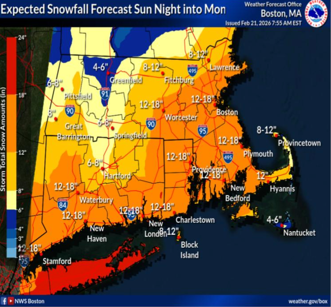
The storm system is expected to move northward from the Gulf Coast this weekend and will strengthen rapidly along the Atlantic Coast, according to AccuWeather, spreading accumulating snow from West Virginia through the mid-Atlantic and into southern New England from Saturday night through Monday.
AccuWeather meteorologists predict the storm will undergo rapid strengthening offshore, producing blizzard conditions in some states, including Massachusetts.
Find out what's happening in Across Massachusettsfor free with the latest updates from Patch.
"Not only will the storm evolve into a significant nor'easter with strong winds and heavy snow along parts of the Atlantic coast, but it may become a bomb cyclone as it begins to move away," said AccuWeather Senior Meteorologist Chad Merrill.
[High Impact Winter Storm] A major winter storm will bring heavy snow with blizzard conditions and power outages possible. High confidence in 10 to 20 inches of snow across eastern MA/RI, but more uncertainty across western MA/CT dependent on the western extent of heavy snow. pic.twitter.com/PKCOYSg87M
— NWS Boston (@NWSBoston) February 21, 2026
Snow is expected to move into central and eastern portions of the state Sunday night. The heaviest snow will likely arrive after 10 p.m. and continue into Monday afternoon.
Additionally, northeast winds will strengthen during the storm. Wind gusts between 40 and 60 mph are possible, which could lead to tree damage and power outages. The winds could also create blizzard conditions in parts of the state, with the greatest risk in eastern Massachusetts.
Major impacts from the storm include slick, snow-covered roads. Gusty winds will reduce visibility and likely cause widespread travel disruptions. Also, widespread closures and disruptions to infrastructure may occur.
Get more local news delivered straight to your inbox. Sign up for free Patch newsletters and alerts.